Property Record
631 N Secrest Ave, Monroe, NC 28110
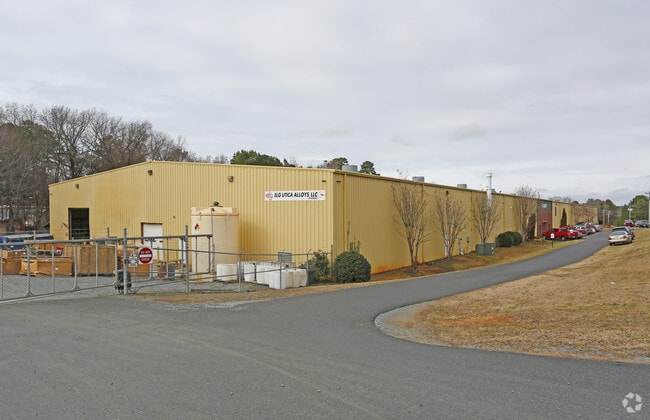

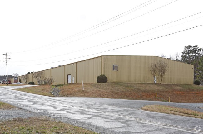

Property Detail
631 N Secrest Ave
09-112-005-D
#3 MICHAELS INDUSTRIAL PARK
Manufacturinglight
Union
G-I MONROE
North Carolina
B and X Area of moderate flood hazard, usually the area between the limits of the 100-year and 500-year floods.
3
2025
4.28 AC
2025
Union County
020601
Charlotte
74,972 SF
Charlotte-Concord-Gastonia, NC-SC
NEARBY LISTINGS FOR SALE OR LEASE
DEMOGRAPHICS near 631 N Secrest Ave
1 mile
3 mile
5 mile
2025 Total Population
2,001
17,821
43,859
2030 Population
2,212
19,517
47,996
Pop Growth 2025-2030
+ 10.54%
+ 9.52%
+ 9.43%
Average Age
34
38
38
2025 Total Households
615
6,014
14,841
HH Growth 2025-2030
+ 10.73%
+ 9.54%
+ 9.72%
Median Household Inc
$58,273
$55,421
$60,541
Avg Household Size
3.10
2.80
2.70
2025 Avg HH Vehicles
2.00
2.00
2.00
Median Home Value
$213,636
$338,389
$325,527
Median Year Built
1990
1984
1988
Nearby Places
Map Layers
Map Styles
 Street
 Aerial
Layers
 Traffic
 Biking
Places
Listings with unknown addresses are not visible on the map
- Restaurants
- Banks
- Shops
- Fitness
- Groceries
PUBLIC TRANSPORTATION
AIRPORT
Charlotte/Douglas International
Drive
Walk
Distance
Charlotte/Douglas International
54 min
34.5 mi
Concord-Padgett Regional
Drive
Walk
Distance
Concord-Padgett Regional
52 min
38.3 mi
Freight Ports
North Charleston Terminal
Drive
Walk
Distance
North Charleston Terminal
224 min
185.5 mi
SALE & LEASE HISTORY
LISTING DATE
SALE/LEASE

Apr 14, 2021
For Lease
Nearby Properties
Address
Land Use
TOTAL SIZE
Lot Size
Zoning
Address
Land Use
TOTAL SIZE
Lot Size
Zoning
82.26 AC
G-I MONROE
Address
Land Use
TOTAL SIZE
Lot Size
Zoning
148,145 SF
26.68 AC
G-I MONROE
Address
Land Use
TOTAL SIZE
Lot Size
Zoning
78.48 AC
Address
Land Use
TOTAL SIZE
Lot Size
Zoning
68,870 SF
33.25 AC
HC WINGATE
Address
Land Use
TOTAL SIZE
Lot Size
Zoning
134,187 SF
32.44 AC
R-10 MONRO
Address
Land Use
TOTAL SIZE
Lot Size
Zoning
99,235 SF
1.92 AC
CBD MONROE
Address
Land Use
TOTAL SIZE
Lot Size
Zoning
68,258 SF
3.39 AC
R-20 WINGA
Address
Land Use
TOTAL SIZE
Lot Size
Zoning
5,376 SF
11.99 AC
R-MF MONRO
Address
Land Use
TOTAL SIZE
Lot Size
Zoning
104,837 SF
29.15 AC
CD MONROE
Address
Land Use
TOTAL SIZE
Lot Size
Zoning
6,672 SF
5.08 AC
OT MONROE
Address
Land Use
TOTAL SIZE
Lot Size
Zoning
2,016 SF
6.20 AC
R-MF MONRO
Address
Land Use
TOTAL SIZE
Lot Size
Zoning
121,790 SF
52.36 AC
G-I MONROE
Address
Land Use
TOTAL SIZE
Lot Size
Zoning
79,493 SF
32.65 AC
RA-20 UNIO
Address
Land Use
TOTAL SIZE
Lot Size
Zoning
2,873 SF
55.59 AC
G-I MONROE
Address
Land Use
TOTAL SIZE
Lot Size
Zoning
32,872 SF
9.35 AC
Address
Land Use
TOTAL SIZE
Lot Size
Zoning
41,820 SF
6.23 AC
G-I MONROE
Address
Land Use
TOTAL SIZE
Lot Size
Zoning
28,468 SF
3.51 AC
B-1 WINGAT
Address
Land Use
TOTAL SIZE
Lot Size
Zoning
32,815 SF
8.28 AC
R-20 MONRO
Address
Land Use
TOTAL SIZE
Lot Size
Zoning
72,444 SF
5.06 AC
GB MONROE
Address
Land Use
TOTAL SIZE
Lot Size
Zoning
214,256 SF
16.68 AC
G-I MONROE
Address
Land Use
TOTAL SIZE
Lot Size
Zoning
2,712 SF
7.11 AC
R-MH MONRO
Address
Land Use
TOTAL SIZE
Lot Size
Zoning
33,699 SF
2.55 AC
OT MONROE
Address
Land Use
TOTAL SIZE
Lot Size
Zoning
80,000 SF
10.19 AC
G-I MONROE
Address
Land Use
TOTAL SIZE
Lot Size
Zoning
18,200 SF
0.76 AC
CBD MONROE
Address
Land Use
TOTAL SIZE
Lot Size
Zoning
20,700 SF
4.76 AC
CBD MONROE
Address
Land Use
TOTAL SIZE
Lot Size
Zoning
13,016 SF
15.38 AC
GB MONROE
Address
Land Use
TOTAL SIZE
Lot Size
Zoning
61,165 SF
6.59 AC
GB MONROE
Address
Land Use
TOTAL SIZE
Lot Size
Zoning
33,946 SF
2.48 AC
CD MONROE
Address
Land Use
TOTAL SIZE
Lot Size
Zoning
97,344 SF
31.11 AC
R-10 MONRO
Address
Land Use
TOTAL SIZE
Lot Size
Zoning
21,576 SF
1.37 AC
GB MONROE
The World's #1 Commercial Real Estate Marketplace
Connect with us
© 2026 CoStar Group
The information above has been obtained from sources believed reliable. While we do not doubt its accuracy we have not verified it and make no guarantee, warranty or representation about it. It is your responsibility to independently confirm its accuracy and completeness. Any projections, opinions, assumptions, or estimates used are for example only and do not represent the current or future performance of the property. The value of this transaction to you depends on tax and other factors which should be evaluated by your tax, financial, and legal advisors. You and your advisors should conduct a careful, independent investigation of the property to determine to your satisfaction the suitability of the property for your needs.