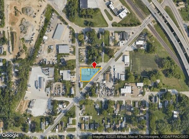
Property Record
6310 Gilmore Ave, Omaha, NE 68107
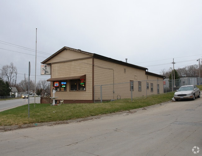

This Property Is For Sale
NEARBY LISTINGS FOR SALE OR LEASE
Property Detail
6310 Gilmore Ave
Omaha-Council Bluffs, NE-IA
Albright Annex
0464-0002-05
ALBRIGHT ANNEX LOT 13 BLOCK 4 N OF GILMORE AVE LT 10 & 11 & ALL LTS 12 & 13
Bartavern
Douglas
X
Nebraska
31153C0080G
13
2024
0.41 AC
2025
Southeast Omaha
002900
Omaha/Council Bluffs
3,361 SF
DEMOGRAPHICS near 6310 Gilmore Ave
1 Mile
3 Mile
5 Mile
2024 Total Population
13,505
78,077
207,790
2029 Population
13,826
80,370
215,246
Pop Growth 2024-2029
+ 2.38%
+ 2.94%
+ 3.59%
Average Age
33
36
36
2024 Total Households
4,143
26,521
82,356
HH Growth 2024-2029
+ 2.63%
+ 3.18%
+ 3.75%
Median Household Inc
$52,849
$58,512
$58,650
Avg Household Size
3.10
2.80
2.40
2024 Avg HH Vehicles
2.00
2.00
2.00
Median Home Value
$128,638
$159,468
$179,832
Median Year Built
1952
1959
1965
Nearby Places
- Restaurants
- Banks
- Shops
- Fitness
- Groceries
PUBLIC TRANSPORTATION
COMMUTER RAIL
Omaha Amtrak Station (California Zephyr - Amtrak)
DRIVE
WALK
Distance
Omaha Amtrak Station (California Zephyr - Amtrak)
9 min
4.7 mi
Omaha Amtrak Station (California Zephyr - Amtrak)
DRIVE
WALK
Distance
Omaha Amtrak Station (California Zephyr - Amtrak)
10 min
4.9 mi
AIRPORT
Eppley Airfield
DRIVE
WALK
Distance
Eppley Airfield
19 min
9.6 mi
Freight Ports
Tulsa Port Of Catoosa
DRIVE
WALK
Distance
Tulsa Port Of Catoosa
458 min
414.1 mi
Nearby Properties
Address
Land Use
TOTAL SIZE
Lot Size
Zoning
Address
Land Use
TOTAL SIZE
Lot Size
Zoning
276,509 SF
3.67 AC
Address
Land Use
TOTAL SIZE
Lot Size
Zoning
160,000 SF
22.48 AC
Address
Land Use
TOTAL SIZE
Lot Size
Zoning
254,734 SF
18.90 AC
Address
Land Use
TOTAL SIZE
Lot Size
Zoning
1,216 SF
22.82 AC
Address
Land Use
TOTAL SIZE
Lot Size
Zoning
12.71 AC
Address
Land Use
TOTAL SIZE
Lot Size
Zoning
119,396 SF
13.46 AC
Address
Land Use
TOTAL SIZE
Lot Size
Zoning
226,320 SF
12.75 AC
Address
Land Use
TOTAL SIZE
Lot Size
Zoning
1,850 SF
8.14 AC
Address
Land Use
TOTAL SIZE
Lot Size
Zoning
400 SF
23.26 AC
Address
Land Use
TOTAL SIZE
Lot Size
Zoning
42,900 SF
16.25 AC
Address
Land Use
TOTAL SIZE
Lot Size
Zoning
212,990 SF
8.75 AC
MH
Address
Land Use
TOTAL SIZE
Lot Size
Zoning
193,967 SF
7.27 AC
Address
Land Use
TOTAL SIZE
Lot Size
Zoning
236,067 SF
10.12 AC
HI
Address
Land Use
TOTAL SIZE
Lot Size
Zoning
33,713 SF
14.39 AC
Address
Land Use
TOTAL SIZE
Lot Size
Zoning
63,669 SF
6.58 AC
Address
Land Use
TOTAL SIZE
Lot Size
Zoning
4.53 AC
Address
Land Use
TOTAL SIZE
Lot Size
Zoning
126,910 SF
13.49 AC
Address
Land Use
TOTAL SIZE
Lot Size
Zoning
3,418 SF
5.56 AC
Address
Land Use
TOTAL SIZE
Lot Size
Zoning
230,995 SF
11.29 AC
HI
Address
Land Use
TOTAL SIZE
Lot Size
Zoning
3.41 AC
A-P
Address
Land Use
TOTAL SIZE
Lot Size
Zoning
131,549 SF
6.13 AC
Address
Land Use
TOTAL SIZE
Lot Size
Zoning
252,694 SF
17.74 AC
HI
Address
Land Use
TOTAL SIZE
Lot Size
Zoning
116,718 SF
8.28 AC
Address
Land Use
TOTAL SIZE
Lot Size
Zoning
161,765 SF
18.32 AC
Address
Land Use
TOTAL SIZE
Lot Size
Zoning
38,595 SF
2.07 AC
Address
Land Use
TOTAL SIZE
Lot Size
Zoning
74,586 SF
4.24 AC
Address
Land Use
TOTAL SIZE
Lot Size
Zoning
85,320 SF
6.60 AC
HI
Address
Land Use
TOTAL SIZE
Lot Size
Zoning
81,172 SF
4 AC
Address
Land Use
TOTAL SIZE
Lot Size
Zoning
1,768 SF
14.80 AC
Address
Land Use
TOTAL SIZE
Lot Size
Zoning
273,738 SF
16.07 AC
The World's #1 Commercial Real Estate Marketplace
Connect with us
© 2025 CoStar Group
The information above has been obtained from sources believed reliable. While we do not doubt its accuracy we have not verified it and make no guarantee, warranty or representation about it. It is your responsibility to independently confirm its accuracy and completeness. Any projections, opinions, assumptions, or estimates used are for example only and do not represent the current or future performance of the property. The value of this transaction to you depends on tax and other factors which should be evaluated by your tax, financial, and legal advisors. You and your advisors should conduct a careful, independent investigation of the property to determine to your satisfaction the suitability of the property for your needs.