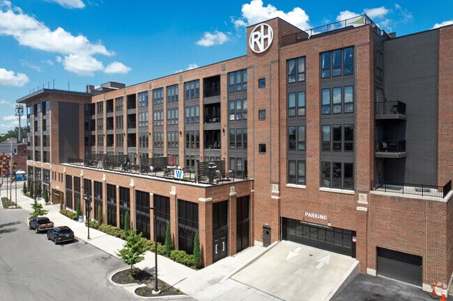
Property Record
6311 E Westfield Blvd, Indianapolis, IN 46220

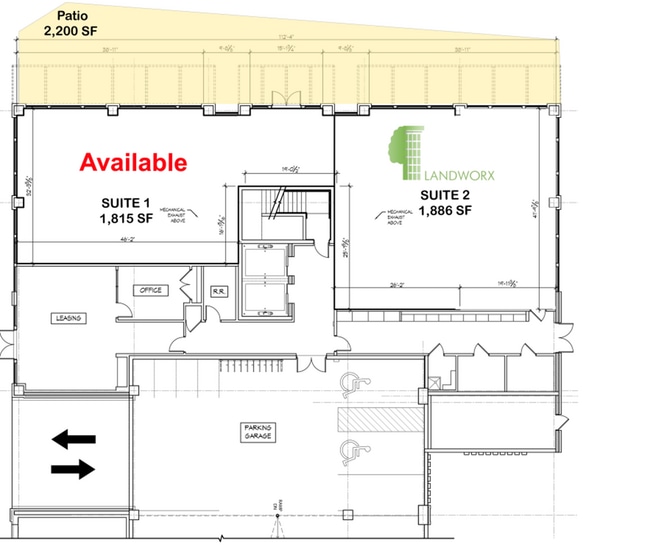
Current Lease Availabilities
NEARBY LISTINGS FOR SALE OR LEASE
Property Detail
6311 E Westfield Blvd
Indianapolis-Carmel-Anderson, IN
Wellington Broad Ripple Pt
49-03-36-101-026.000-801
WELLINGTON BROAD RIPPLE PT L1 TO 4 & PT SW1/4S36 T17 R3 BEG 4.774FT N OF SW COR L4 N 21.224FTNE 120.515FT SE IRR 331.343FT SE 63.56FT W379.805FT NW 4.912FT TO BEG .87AC
Apartment
Marion
AE
Indiana
18097C0135F
1-4,4
2023
0.87 AC
2024
Broad Ripple
320700
Indianapolis
33,892 SF
DEMOGRAPHICS near 6311 E Westfield Blvd
1 Mile
3 Mile
5 Mile
2024 Total Population
11,180
76,694
221,983
2029 Population
11,040
75,844
221,843
Pop Growth 2024-2029
(1.25%)
(1.11%)
(0.06%)
Average Age
38
39
39
2024 Total Households
5,734
33,832
97,443
HH Growth 2024-2029
(1.34%)
(1.26%)
(0.19%)
Median Household Inc
$112,932
$89,310
$64,942
Avg Household Size
1.90
2.10
2.20
2024 Avg HH Vehicles
2.00
2.00
2.00
Median Home Value
$319,096
$290,783
$253,010
Median Year Built
1952
1958
1966
Nearby Places
Map Layers
Map Styles
 Street
 Aerial
- Restaurants
- Banks
- Shops
- Fitness
- Groceries
PUBLIC TRANSPORTATION
AIRPORT
Indianapolis International
DRIVE
WALK
Distance
Indianapolis International
36 min
23.6 mi
Freight Ports
Virginia Port Authority - Richmond
DRIVE
WALK
Distance
Virginia Port Authority - Richmond
1 min
498.9 mi
Nearby Properties
Address
Land Use
TOTAL SIZE
Lot Size
Zoning
Address
Land Use
TOTAL SIZE
Lot Size
Zoning
4,146 SF
45.91 AC
ZO01
Address
Land Use
TOTAL SIZE
Lot Size
Zoning
8,157 SF
113.93 AC
ZO01
Address
Land Use
TOTAL SIZE
Lot Size
Zoning
50,698 SF
13.58 AC
Address
Land Use
TOTAL SIZE
Lot Size
Zoning
76,657 SF
9.45 AC
ZO01
Address
Land Use
TOTAL SIZE
Lot Size
Zoning
207,800 SF
2.23 AC
ZO01
Address
Land Use
TOTAL SIZE
Lot Size
Zoning
272,688 SF
14.60 AC
ZO01
Address
Land Use
TOTAL SIZE
Lot Size
Zoning
2,156 SF
0.46 AC
ZO01
Address
Land Use
TOTAL SIZE
Lot Size
Zoning
2.81 AC
ZO01
Address
Land Use
TOTAL SIZE
Lot Size
Zoning
23,195 SF
31.18 AC
Address
Land Use
TOTAL SIZE
Lot Size
Zoning
13,789 SF
3.93 AC
ZO01
Address
Land Use
TOTAL SIZE
Lot Size
Zoning
2,313 SF
35.45 AC
ZO01
Address
Land Use
TOTAL SIZE
Lot Size
Zoning
29,662 SF
17.96 AC
ZO01
Address
Land Use
TOTAL SIZE
Lot Size
Zoning
1,080 SF
19.24 AC
Address
Land Use
TOTAL SIZE
Lot Size
Zoning
98,790 SF
0.18 AC
ZO01
Address
Land Use
TOTAL SIZE
Lot Size
Zoning
5,670 SF
25.69 AC
Address
Land Use
TOTAL SIZE
Lot Size
Zoning
81,511 SF
13.55 AC
Address
Land Use
TOTAL SIZE
Lot Size
Zoning
33,127 SF
11.51 AC
ZO01
Address
Land Use
TOTAL SIZE
Lot Size
Zoning
170,049 SF
12.74 AC
ZO01
Address
Land Use
TOTAL SIZE
Lot Size
Zoning
80,072 SF
32.54 AC
Address
Land Use
TOTAL SIZE
Lot Size
Zoning
1,903 SF
20.77 AC
ZO01
Address
Land Use
TOTAL SIZE
Lot Size
Zoning
9,930 SF
9.10 AC
ZO01
Address
Land Use
TOTAL SIZE
Lot Size
Zoning
7,740 SF
2.04 AC
ZO01
Address
Land Use
TOTAL SIZE
Lot Size
Zoning
63,490 SF
29.07 AC
ZO01
Address
Land Use
TOTAL SIZE
Lot Size
Zoning
5,841 SF
28.99 AC
ZO01
Address
Land Use
TOTAL SIZE
Lot Size
Zoning
2,951 SF
15.45 AC
ZO01
Address
Land Use
TOTAL SIZE
Lot Size
Zoning
46,320 SF
14.93 AC
ZO01
Address
Land Use
TOTAL SIZE
Lot Size
Zoning
66,953 SF
10.87 AC
ZO01
Address
Land Use
TOTAL SIZE
Lot Size
Zoning
17,621 SF
3.20 AC
ZO01
Address
Land Use
TOTAL SIZE
Lot Size
Zoning
1,551 SF
1.23 AC
ZO01
The World's #1 Commercial Real Estate Marketplace
Connect with us
© 2026 CoStar Group
The information above has been obtained from sources believed reliable. While we do not doubt its accuracy we have not verified it and make no guarantee, warranty or representation about it. It is your responsibility to independently confirm its accuracy and completeness. Any projections, opinions, assumptions, or estimates used are for example only and do not represent the current or future performance of the property. The value of this transaction to you depends on tax and other factors which should be evaluated by your tax, financial, and legal advisors. You and your advisors should conduct a careful, independent investigation of the property to determine to your satisfaction the suitability of the property for your needs.