Property Record
6315 Pedley Rd, Jurupa Valley, CA 92509
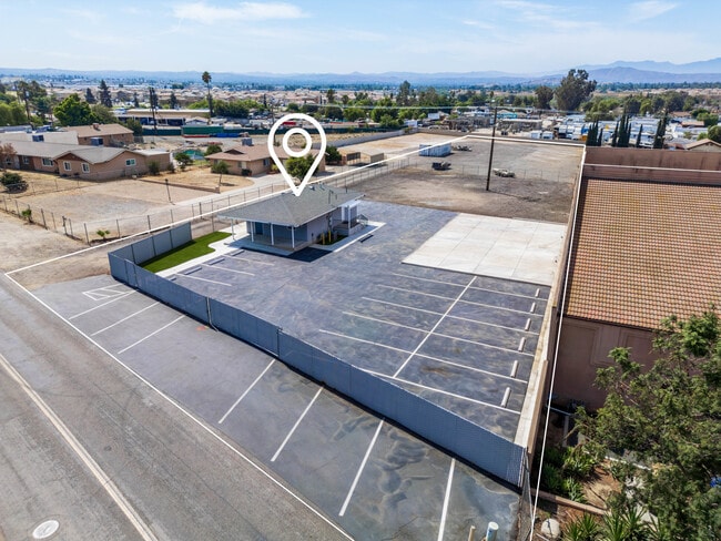
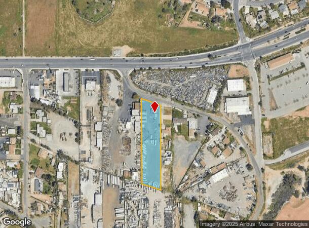


This Property Is For Sale
NEARBY LISTINGS FOR SALE OR LEASE
Property Detail
6315 Pedley Rd
Riverside-San Bernardino-Ontario, CA
Sparrland Unit 6
163-180-010
1.52 ACRES M/L IN POR LOTS 5 & 6 BLK 35 MB 015/064 SPARRLAND UNIT 6
Storebuilding
Riverside
X
California
06065C0705H
6
2024
1.52 AC
2025
Riverside
040404
Inland Empire (California)
616 SF
DEMOGRAPHICS near 6315 Pedley Rd
1 Mile
3 Mile
5 Mile
2024 Total Population
8,870
90,054
287,462
2029 Population
9,171
91,543
292,325
Pop Growth 2024-2029
+ 3.39%
+ 1.65%
+ 1.69%
Average Age
38
36
36
2024 Total Households
2,406
23,261
79,623
HH Growth 2024-2029
+ 3.16%
+ 1.20%
+ 1.23%
Median Household Inc
$103,125
$94,277
$93,113
Avg Household Size
3.50
3.60
3.40
2024 Avg HH Vehicles
3.00
3.00
2.00
Median Home Value
$652,003
$613,112
$623,900
Median Year Built
1983
1975
1976
Nearby Places
Map Layers
Map Styles
 Street
 Aerial
- Restaurants
- Banks
- Shops
- Fitness
- Groceries
PUBLIC TRANSPORTATION
TRANSIT/SUBWAY
Pedley (Riverside Line - Southern California Regional Rail Authority (Metrolink))
DRIVE
WALK
Distance
Pedley (Riverside Line - Southern California Regional Rail Authority (Metrolink))
2 min
11 min
0.6 mi
COMMUTER RAIL
Pedley (Riverside Line - Southern California Regional Rail Authority (Metrolink))
DRIVE
WALK
Distance
Pedley (Riverside Line - Southern California Regional Rail Authority (Metrolink))
2 min
11 min
0.6 mi
Riverside-Downtown (91 Line - Southern California Regional Rail Authority (Metrolink), Inland Empire-Orange County Line - Southern California Regional Rail Authority (Metrolink), Riverside Line - Southern California Regional Rail Authority (Metrolink))
DRIVE
WALK
Distance
Riverside-Downtown (91 Line - Southern California Regional Rail Authority (Metrolink), Inland Empire-Orange County Line - Southern California Regional Rail Authority (Metrolink), Riverside Line - Southern California Regional Rail Authority (Metrolink))
15 min
7.3 mi
AIRPORT
Ontario International
DRIVE
WALK
Distance
Ontario International
17 min
9.9 mi
John Wayne/Orange County
DRIVE
WALK
Distance
John Wayne/Orange County
52 min
40.7 mi
Freight Ports
Port of Long Beach
DRIVE
WALK
Distance
Port of Long Beach
74 min
54.8 mi
Nearby Properties
Address
Land Use
TOTAL SIZE
Lot Size
Zoning
Address
Land Use
TOTAL SIZE
Lot Size
Zoning
43,152 SF
6.76 AC
R3S2
Address
Land Use
TOTAL SIZE
Lot Size
Zoning
855,621 SF
46.79 AC
I
Address
Land Use
TOTAL SIZE
Lot Size
Zoning
179,589 SF
18.62 AC
Address
Land Use
TOTAL SIZE
Lot Size
Zoning
157,112 SF
10.83 AC
Address
Land Use
TOTAL SIZE
Lot Size
Zoning
8.75 AC
R1065
Address
Land Use
TOTAL SIZE
Lot Size
Zoning
14,068 SF
6.61 AC
R3
Address
Land Use
TOTAL SIZE
Lot Size
Zoning
110,680 SF
11.88 AC
MP
Address
Land Use
TOTAL SIZE
Lot Size
Zoning
73,538 SF
4.11 AC
R3150
Address
Land Use
TOTAL SIZE
Lot Size
Zoning
63,718 SF
7.25 AC
R3
Address
Land Use
TOTAL SIZE
Lot Size
Zoning
18,480 SF
7.19 AC
Address
Land Use
TOTAL SIZE
Lot Size
Zoning
80,257 SF
5.02 AC
C1CP
Address
Land Use
TOTAL SIZE
Lot Size
Zoning
40,024 SF
4.84 AC
Address
Land Use
TOTAL SIZE
Lot Size
Zoning
149,829 SF
11.60 AC
Address
Land Use
TOTAL SIZE
Lot Size
Zoning
97,459 SF
3.89 AC
Address
Land Use
TOTAL SIZE
Lot Size
Zoning
81,250 SF
6.22 AC
Address
Land Use
TOTAL SIZE
Lot Size
Zoning
130,900 SF
15.08 AC
A1R
Address
Land Use
TOTAL SIZE
Lot Size
Zoning
62,619 SF
3.08 AC
C1CP
Address
Land Use
TOTAL SIZE
Lot Size
Zoning
86,590 SF
5.63 AC
AIR
Address
Land Use
TOTAL SIZE
Lot Size
Zoning
144,158 SF
8.90 AC
Address
Land Use
TOTAL SIZE
Lot Size
Zoning
88,522 SF
20.89 AC
M1
Address
Land Use
TOTAL SIZE
Lot Size
Zoning
48,434 SF
2.33 AC
C1CP
Address
Land Use
TOTAL SIZE
Lot Size
Zoning
53,428 SF
2.53 AC
C1CP
Address
Land Use
TOTAL SIZE
Lot Size
Zoning
16.76 AC
MSC
Address
Land Use
TOTAL SIZE
Lot Size
Zoning
32,074 SF
3.78 AC
W2
Address
Land Use
TOTAL SIZE
Lot Size
Zoning
90,500 SF
19.96 AC
MSC
Address
Land Use
TOTAL SIZE
Lot Size
Zoning
83,858 SF
2.53 AC
The World's #1 Commercial Real Estate Marketplace
Connect with us
© 2025 CoStar Group
The information above has been obtained from sources believed reliable. While we do not doubt its accuracy we have not verified it and make no guarantee, warranty or representation about it. It is your responsibility to independently confirm its accuracy and completeness. Any projections, opinions, assumptions, or estimates used are for example only and do not represent the current or future performance of the property. The value of this transaction to you depends on tax and other factors which should be evaluated by your tax, financial, and legal advisors. You and your advisors should conduct a careful, independent investigation of the property to determine to your satisfaction the suitability of the property for your needs.