Property Record
63160 Britta St, Bend, OR 97703
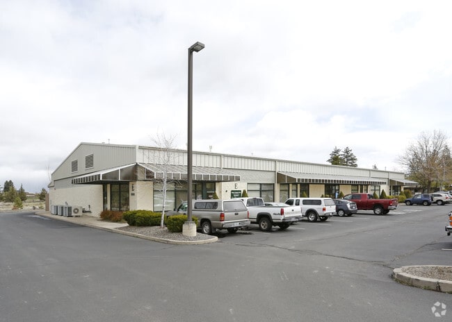

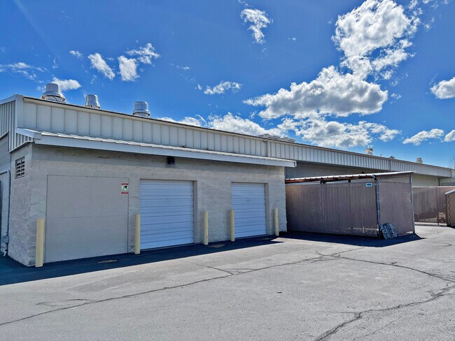
Property Detail
63160 Britta St
183013
EMPIRE CORPORATE PARK LOT 4
Industrialgeneral
Deschutes
ME
Oregon
B and X Area of moderate flood hazard, usually the area between the limits of the 100-year and 500-year floods.
4
2025
1.43 AC
2025
Deschutes County
001102
Portland
13,440 SF
Bend, OR
NEARBY LISTINGS FOR SALE OR LEASE
DEMOGRAPHICS near 63160 Britta St
1 mile
3 mile
5 mile
2025 Total Population
5,028
50,854
95,322
2030 Population
5,129
51,966
97,750
Pop Growth 2025-2030
+ 2.01%
+ 2.19%
+ 2.55%
Average Age
41
41
41
2025 Total Households
1,933
21,118
39,051
HH Growth 2025-2030
+ 2.07%
+ 2.13%
+ 2.51%
Median Household Inc
$127,199
$106,427
$103,783
Avg Household Size
2.50
2.30
2.40
2025 Avg HH Vehicles
2.00
2.00
2.00
Median Home Value
$799,561
$788,874
$774,697
Median Year Built
2005
1997
2000
Nearby Places
Map Layers
Map Styles
 Street
 Aerial
Layers
 Traffic
 Biking
Places
Listings with unknown addresses are not visible on the map
- Restaurants
- Banks
- Shops
- Fitness
- Groceries
PUBLIC TRANSPORTATION
AIRPORT
Roberts Field
Drive
Walk
Distance
Roberts Field
22 min
15.0 mi
SALE & LEASE HISTORY
LISTING DATE
SALE/LEASE

Sep 25, 2016
For Lease
Oct 19, 2017
For Lease
Jul 07, 2022
For Lease
Nearby Properties
Address
Land Use
TOTAL SIZE
Lot Size
Zoning
Address
Land Use
TOTAL SIZE
Lot Size
Zoning
61,869 SF
35.14 AC
RH
Address
Land Use
TOTAL SIZE
Lot Size
Zoning
35.14 AC
Address
Land Use
TOTAL SIZE
Lot Size
Zoning
10,490 SF
35.14 AC
RH
Address
Land Use
TOTAL SIZE
Lot Size
Zoning
116,476 SF
35.14 AC
RH
Address
Land Use
TOTAL SIZE
Lot Size
Zoning
144,000 SF
35.14 AC
RH
Address
Land Use
TOTAL SIZE
Lot Size
Zoning
35.14 AC
RH
Address
Land Use
TOTAL SIZE
Lot Size
Zoning
144,000 SF
35.14 AC
RH
Address
Land Use
TOTAL SIZE
Lot Size
Zoning
35.14 AC
RH
Address
Land Use
TOTAL SIZE
Lot Size
Zoning
11,947 SF
35.14 AC
RH
Address
Land Use
TOTAL SIZE
Lot Size
Zoning
35.14 AC
Address
Land Use
TOTAL SIZE
Lot Size
Zoning
35.14 AC
RH
Address
Land Use
TOTAL SIZE
Lot Size
Zoning
35.14 AC
RH
Address
Land Use
TOTAL SIZE
Lot Size
Zoning
35.14 AC
RH
Address
Land Use
TOTAL SIZE
Lot Size
Zoning
35.14 AC
RH
Address
Land Use
TOTAL SIZE
Lot Size
Zoning
144,000 SF
35.14 AC
RH
Address
Land Use
TOTAL SIZE
Lot Size
Zoning
35.14 AC
RH
Address
Land Use
TOTAL SIZE
Lot Size
Zoning
35.14 AC
Address
Land Use
TOTAL SIZE
Lot Size
Zoning
12,000 SF
2.77 AC
IL
Address
Land Use
TOTAL SIZE
Lot Size
Zoning
2.77 AC
IL
Address
Land Use
TOTAL SIZE
Lot Size
Zoning
7.99 AC
IL
Address
Land Use
TOTAL SIZE
Lot Size
Zoning
7.99 AC
IL
Address
Land Use
TOTAL SIZE
Lot Size
Zoning
317,867 SF
32.72 AC
CG
Address
Land Use
TOTAL SIZE
Lot Size
Zoning
201,150 SF
3.75 AC
RH
Address
Land Use
TOTAL SIZE
Lot Size
Zoning
1,546 SF
6.41 AC
RH
Address
Land Use
TOTAL SIZE
Lot Size
Zoning
1.04 AC
CB
Address
Land Use
TOTAL SIZE
Lot Size
Zoning
201,575 SF
1.04 AC
CB
Address
Land Use
TOTAL SIZE
Lot Size
Zoning
229,286 SF
17.96 AC
CG
Address
Land Use
TOTAL SIZE
Lot Size
Zoning
70,294 SF
17.96 AC
CG
Address
Land Use
TOTAL SIZE
Lot Size
Zoning
24.36 AC
Address
Land Use
TOTAL SIZE
Lot Size
Zoning
24.36 AC
IG
The World's #1 Commercial Real Estate Marketplace
Connect with us
© 2026 CoStar Group
The information above has been obtained from sources believed reliable. While we do not doubt its accuracy we have not verified it and make no guarantee, warranty or representation about it. It is your responsibility to independently confirm its accuracy and completeness. Any projections, opinions, assumptions, or estimates used are for example only and do not represent the current or future performance of the property. The value of this transaction to you depends on tax and other factors which should be evaluated by your tax, financial, and legal advisors. You and your advisors should conduct a careful, independent investigation of the property to determine to your satisfaction the suitability of the property for your needs.