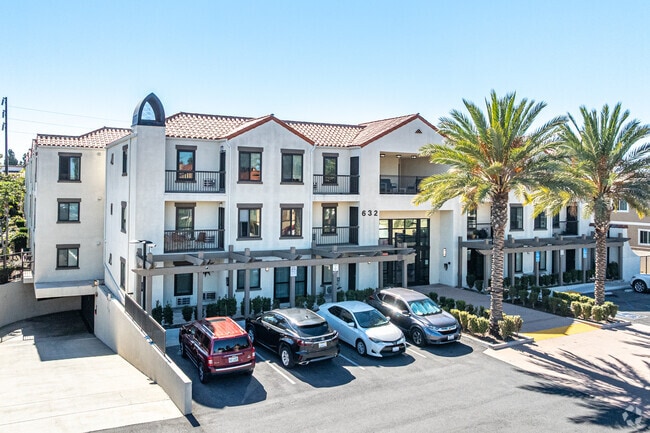
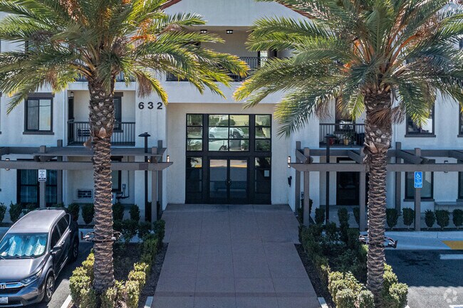
Property Record
632 E 219Th St, Carson, CA 90745


Property Detail
632 E 219Th St
7335-011-016
TRACT NO 2982 E 150 FT OF W 377 FT OF S 285 FT OF LOT 34
Multifamilydwelling
Los Angeles
CARM12U&D*
California
B and X Area of moderate flood hazard, usually the area between the limits of the 100-year and 500-year floods.
34
2024
0.99 AC
2025
Carson
543803
Los Angeles
55,980 SF
Los Angeles-Long Beach-Glendale, CA
NEARBY LISTINGS FOR SALE OR LEASE
DEMOGRAPHICS near 632 E 219Th St
1 mile
3 mile
5 mile
2024 Total Population
28,914
179,560
488,288
2029 Population
28,619
177,377
483,280
Pop Growth 2024-2029
(1.02%)
(1.22%)
(1.03%)
Average Age
44
42
41
2024 Total Households
7,808
53,517
154,270
HH Growth 2024-2029
(1.24%)
(1.44%)
(1.21%)
Median Household Inc
$106,643
$94,174
$87,970
Avg Household Size
3.30
3.20
3.00
2024 Avg HH Vehicles
2.00
2.00
2.00
Median Home Value
$684,546
$702,005
$736,752
Median Year Built
1965
1965
1963
Nearby Places
Map Layers
Map Styles
 Street
 Aerial
Transit
 Traffic
 Biking
Places
Listings with unknown addresses are not visible on the map
- Restaurants
- Banks
- Shops
- Fitness
- Groceries
PUBLIC TRANSPORTATION
AIRPORT
Long Beach (Daugherty Field)
Drive
Walk
Distance
Long Beach (Daugherty Field)
12 min
6.9 mi
Los Angeles International
Drive
Walk
Distance
Los Angeles International
21 min
14.4 mi
John Wayne/Orange County
Drive
Walk
Distance
John Wayne/Orange County
34 min
27.2 mi
Freight Ports
Port of Long Beach
Drive
Walk
Distance
Port of Long Beach
14 min
8.8 mi
Nearby Properties
Address
Land Use
TOTAL SIZE
Lot Size
Zoning
Address
Land Use
TOTAL SIZE
Lot Size
Zoning
997,143 SF
98.35 AC
TOMI-BP
Address
Land Use
TOTAL SIZE
Lot Size
Zoning
236,582 SF
425.41 AC
CAMH*
Address
Land Use
TOTAL SIZE
Lot Size
Zoning
64,456 SF
11.71 AC
CASP-10*
Address
Land Use
TOTAL SIZE
Lot Size
Zoning
422,640 SF
LAM3
Address
Land Use
TOTAL SIZE
Lot Size
Zoning
506,189 SF
20.33 AC
LAM2
Address
Land Use
TOTAL SIZE
Lot Size
Zoning
286,186 SF
8.20 AC
LAMR1
Address
Land Use
TOTAL SIZE
Lot Size
Zoning
108,891 SF
224.14 AC
CAMH*
Address
Land Use
TOTAL SIZE
Lot Size
Zoning
409,522 SF
11.41 AC
LAM3
Address
Land Use
TOTAL SIZE
Lot Size
Zoning
246,981 SF
11.95 AC
LARD2
Address
Land Use
TOTAL SIZE
Lot Size
Zoning
184,300 SF
8.14 AC
LAM3
Address
Land Use
TOTAL SIZE
Lot Size
Zoning
285,314 SF
14.28 AC
CAMH*
Address
Land Use
TOTAL SIZE
Lot Size
Zoning
84,365 SF
7.62 AC
LARAS3
Address
Land Use
TOTAL SIZE
Lot Size
Zoning
260,766 SF
10.70 AC
LAM3
Address
Land Use
TOTAL SIZE
Lot Size
Zoning
429,141 SF
3.29 AC
LCM1*
Address
Land Use
TOTAL SIZE
Lot Size
Zoning
383,109 SF
17 AC
LCM2
Address
Land Use
TOTAL SIZE
Lot Size
Zoning
198,502 SF
LCM2 *
Address
Land Use
TOTAL SIZE
Lot Size
Zoning
1,800 SF
124.45 AC
CAMH*
Address
Land Use
TOTAL SIZE
Lot Size
Zoning
213,408 SF
13.81 AC
LBR4R
Address
Land Use
TOTAL SIZE
Lot Size
Zoning
135,666 SF
LAM3
Address
Land Use
TOTAL SIZE
Lot Size
Zoning
365,701 SF
2.45 AC
TOMI-BP
Address
Land Use
TOTAL SIZE
Lot Size
Zoning
14.80 AC
CAMH*
Address
Land Use
TOTAL SIZE
Lot Size
Zoning
340,121 SF
13 AC
LCM2
Address
Land Use
TOTAL SIZE
Lot Size
Zoning
430,706 SF
18.95 AC
CASP-4*
Address
Land Use
TOTAL SIZE
Lot Size
Zoning
125,849 SF
6.08 AC
LAM2
Address
Land Use
TOTAL SIZE
Lot Size
Zoning
10.30 AC
TOM2*
Address
Land Use
TOTAL SIZE
Lot Size
Zoning
178,323 SF
12.23 AC
CACR&D&MUR
Address
Land Use
TOTAL SIZE
Lot Size
Zoning
546,606 SF
17.58 AC
LAM3
Address
Land Use
TOTAL SIZE
Lot Size
Zoning
169,056 SF
10.04 AC
LBR4R
Address
Land Use
TOTAL SIZE
Lot Size
Zoning
499,562 SF
6.50 AC
LAM3
Address
Land Use
TOTAL SIZE
Lot Size
Zoning
536,092 SF
3.79 AC
LAM3
The World's #1 Commercial Real Estate Marketplace
Connect with us
© 2026 CoStar Group
The information above has been obtained from sources believed reliable. While we do not doubt its accuracy we have not verified it and make no guarantee, warranty or representation about it. It is your responsibility to independently confirm its accuracy and completeness. Any projections, opinions, assumptions, or estimates used are for example only and do not represent the current or future performance of the property. The value of this transaction to you depends on tax and other factors which should be evaluated by your tax, financial, and legal advisors. You and your advisors should conduct a careful, independent investigation of the property to determine to your satisfaction the suitability of the property for your needs.