Property Record
632 Lindero Canyon Rd, Oak Park, CA 91377


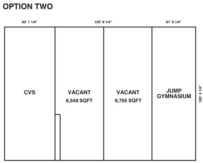

Current Lease Availabilities
NEARBY LISTINGS FOR SALE OR LEASE
Property Detail
632 Lindero Canyon Rd
Oxnard-Thousand Oaks-Ventura, CA
Parcel Map No 4621
685-0-330-035
LOT: 1 REF: 49 PM 82
Regionalshoppingcenterormallwithanchorstore
Ventura
X
California
06111C0995E
1
2024
3.97 AC
2025
Moorpark/Simi Valley
007403
Los Angeles
22,684 SF
DEMOGRAPHICS near 632 Lindero Canyon Rd
1 Mile
3 Mile
5 Mile
2024 Total Population
8,207
40,794
111,919
2029 Population
8,073
39,840
109,862
Pop Growth 2024-2029
(1.63%)
(2.34%)
(1.84%)
Average Age
43
44
44
2024 Total Households
3,139
15,180
42,002
HH Growth 2024-2029
(1.82%)
(2.50%)
(1.97%)
Median Household Inc
$146,857
$153,147
$136,723
Avg Household Size
2.60
2.70
2.60
2024 Avg HH Vehicles
2.00
2.00
2.00
Median Home Value
$951,479
$951,749
$917,133
Median Year Built
1986
1983
1981
Nearby Places
Map Layers
Map Styles
 Street
 Aerial
- Restaurants
- Banks
- Shops
- Fitness
- Groceries
PUBLIC TRANSPORTATION
AIRPORT
Bob Hope
DRIVE
WALK
Distance
Bob Hope
45 min
31.5 mi
Los Angeles International
DRIVE
WALK
Distance
Los Angeles International
54 min
39.7 mi
Nearby Properties
Address
Land Use
TOTAL SIZE
Lot Size
Zoning
Address
Land Use
TOTAL SIZE
Lot Size
Zoning
38,851 SF
40.49 AC
M-1
Address
Land Use
TOTAL SIZE
Lot Size
Zoning
676,545 SF
19.76 AC
WVM1*
Address
Land Use
TOTAL SIZE
Lot Size
Zoning
142,150 SF
15.35 AC
AH SP*
Address
Land Use
TOTAL SIZE
Lot Size
Zoning
736,464 SF
19.64 AC
WVM1*
Address
Land Use
TOTAL SIZE
Lot Size
Zoning
17,278 SF
15.46 AC
Address
Land Use
TOTAL SIZE
Lot Size
Zoning
163,773 SF
5.80 AC
Address
Land Use
TOTAL SIZE
Lot Size
Zoning
142,738 SF
5.56 AC
AH BP-M-FC
Address
Land Use
TOTAL SIZE
Lot Size
Zoning
168,729 SF
10.21 AC
WVM1*
Address
Land Use
TOTAL SIZE
Lot Size
Zoning
142,578 SF
6.13 AC
Address
Land Use
TOTAL SIZE
Lot Size
Zoning
2,398 SF
11.59 AC
C2
Address
Land Use
TOTAL SIZE
Lot Size
Zoning
169,597 SF
7.19 AC
AH SP*
Address
Land Use
TOTAL SIZE
Lot Size
Zoning
116,906 SF
6.35 AC
LCA21*
Address
Land Use
TOTAL SIZE
Lot Size
Zoning
201,223 SF
6.94 AC
LCA21*
Address
Land Use
TOTAL SIZE
Lot Size
Zoning
365,098 SF
18.18 AC
WVM1*
Address
Land Use
TOTAL SIZE
Lot Size
Zoning
138,762 SF
8.69 AC
LCA21*
Address
Land Use
TOTAL SIZE
Lot Size
Zoning
123,248 SF
8.70 AC
RPD2
Address
Land Use
TOTAL SIZE
Lot Size
Zoning
230,960 SF
6.99 AC
WVM1*
Address
Land Use
TOTAL SIZE
Lot Size
Zoning
115,790 SF
5.41 AC
WVM1*
Address
Land Use
TOTAL SIZE
Lot Size
Zoning
2.13 AC
M1
Address
Land Use
TOTAL SIZE
Lot Size
Zoning
28,309 SF
5 AC
C2
Address
Land Use
TOTAL SIZE
Lot Size
Zoning
10,201 SF
0.81 AC
Address
Land Use
TOTAL SIZE
Lot Size
Zoning
86,558 SF
8.83 AC
AHC3*
Address
Land Use
TOTAL SIZE
Lot Size
Zoning
117,968 SF
6.19 AC
AH BP-M-FC
Address
Land Use
TOTAL SIZE
Lot Size
Zoning
71,159 SF
5.74 AC
AH BP-OR-F
Address
Land Use
TOTAL SIZE
Lot Size
Zoning
Address
Land Use
TOTAL SIZE
Lot Size
Zoning
59,772 SF
9.76 AC
M-1
Address
Land Use
TOTAL SIZE
Lot Size
Zoning
65,546 SF
4.08 AC
LCA21*
Address
Land Use
TOTAL SIZE
Lot Size
Zoning
183,251 SF
11.60 AC
RPD-19-
Address
Land Use
TOTAL SIZE
Lot Size
Zoning
191,936 SF
11.59 AC
RPD-19-
Address
Land Use
TOTAL SIZE
Lot Size
Zoning
73,731 SF
0.89 AC
C4
The World's #1 Commercial Real Estate Marketplace
Connect with us
© 2025 CoStar Group
The information above has been obtained from sources believed reliable. While we do not doubt its accuracy we have not verified it and make no guarantee, warranty or representation about it. It is your responsibility to independently confirm its accuracy and completeness. Any projections, opinions, assumptions, or estimates used are for example only and do not represent the current or future performance of the property. The value of this transaction to you depends on tax and other factors which should be evaluated by your tax, financial, and legal advisors. You and your advisors should conduct a careful, independent investigation of the property to determine to your satisfaction the suitability of the property for your needs.