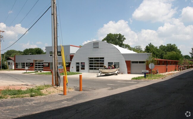
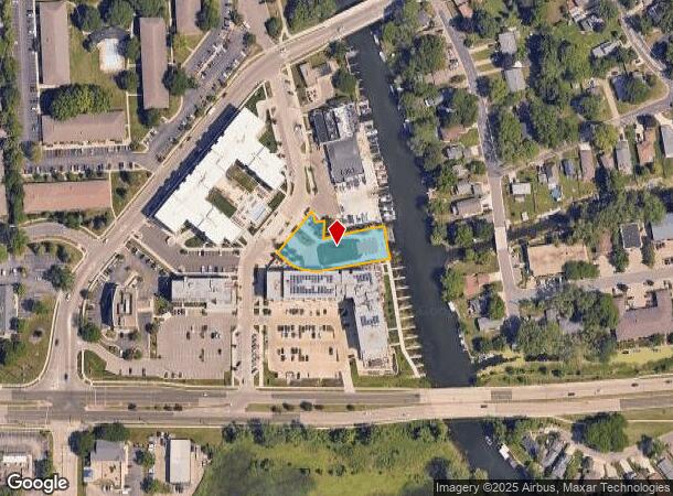
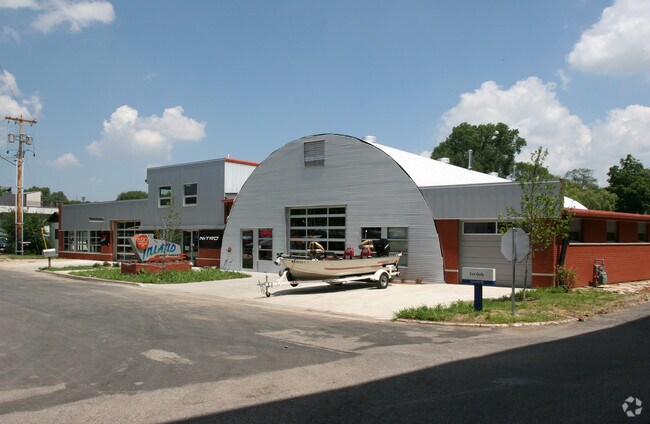
Property Record
6320 Inland Way, Monona, WI 53713
NEARBY LISTINGS FOR SALE OR LEASE
Property Detail
6320 Inland Way
Madison, WI
Monona
0710-203-5044-2
OUTLOT 1 CSM 14728 CS102/262&266-2/27/2018 F/K/A PRT OF LOTS 1 & 3 & ALL OF LOTS 2, 4 & 5 ASSR PLAT NO 12 VIL OF MONONA & ALSO F/K/A ALL OF LOTS 1 -9 INCL BLOCK 1 INTERLAKE PARK & ALSO INCL & DESCR AS SEC 20-7-10 PRT SE1/SW1/4 & SEC 29-7-10 PRT NE1/4
Taxexempt
Dane
AE
Wisconsin
55025C0437H
44
0
0.59 AC
2024
Southeast Madison
001501
Milwaukee/Madison
DEMOGRAPHICS near 6320 Inland Way
1 Mile
3 Mile
5 Mile
2024 Total Population
7,178
45,917
178,294
2029 Population
7,470
47,619
184,086
Pop Growth 2024-2029
+ 4.07%
+ 3.71%
+ 3.25%
Average Age
42
40
36
2024 Total Households
3,349
21,764
79,394
HH Growth 2024-2029
+ 4.21%
+ 3.82%
+ 3.49%
Median Household Inc
$70,726
$69,694
$62,722
Avg Household Size
2.10
2.00
2.00
2024 Avg HH Vehicles
2.00
2.00
1.00
Median Home Value
$327,083
$297,781
$310,914
Median Year Built
1970
1969
1974
Nearby Places
Map Layers
Map Styles
 Street
 Aerial
- Restaurants
- Banks
- Shops
- Fitness
- Groceries
PUBLIC TRANSPORTATION
AIRPORT
Dane County Regional/Truax Field
DRIVE
WALK
Distance
Dane County Regional/Truax Field
18 min
9.4 mi
Freight Ports
Port Milwaukee
DRIVE
WALK
Distance
Port Milwaukee
96 min
81.1 mi
Nearby Properties
Address
Land Use
TOTAL SIZE
Lot Size
Zoning
Address
Land Use
TOTAL SIZE
Lot Size
Zoning
280,769 SF
0.80 AC
UMX
Address
Land Use
TOTAL SIZE
Lot Size
Zoning
421,021 SF
1.30 AC
DC
Address
Land Use
TOTAL SIZE
Lot Size
Zoning
207,221 SF
0.60 AC
UMX
Address
Land Use
TOTAL SIZE
Lot Size
Zoning
230,504 SF
0.76 AC
PD
Address
Land Use
TOTAL SIZE
Lot Size
Zoning
168,685 SF
14.05 AC
IL
Address
Land Use
TOTAL SIZE
Lot Size
Zoning
13,440 SF
10.98 AC
IL
Address
Land Use
TOTAL SIZE
Lot Size
Zoning
247,984 SF
1 AC
HIS-L
Address
Land Use
TOTAL SIZE
Lot Size
Zoning
169,491 SF
0.79 AC
HIS-L
Address
Land Use
TOTAL SIZE
Lot Size
Zoning
2.03 AC
Address
Land Use
TOTAL SIZE
Lot Size
Zoning
13.40 AC
Address
Land Use
TOTAL SIZE
Lot Size
Zoning
148,747 SF
0.83 AC
TE
Address
Land Use
TOTAL SIZE
Lot Size
Zoning
3.59 AC
Address
Land Use
TOTAL SIZE
Lot Size
Zoning
73,125 SF
1.49 AC
HIS-TL
Address
Land Use
TOTAL SIZE
Lot Size
Zoning
192,840 SF
0.37 AC
DC
Address
Land Use
TOTAL SIZE
Lot Size
Zoning
12,450 SF
9.40 AC
SE
Address
Land Use
TOTAL SIZE
Lot Size
Zoning
180,552 SF
1.66 AC
PD
Address
Land Use
TOTAL SIZE
Lot Size
Zoning
2.38 AC
Address
Land Use
TOTAL SIZE
Lot Size
Zoning
158,832 SF
0.58 AC
PD
Address
Land Use
TOTAL SIZE
Lot Size
Zoning
4,992 SF
4.09 AC
SE
Address
Land Use
TOTAL SIZE
Lot Size
Zoning
19.81 AC
Address
Land Use
TOTAL SIZE
Lot Size
Zoning
122,281 SF
0.37 AC
PD
Address
Land Use
TOTAL SIZE
Lot Size
Zoning
149,897 SF
17.72 AC
IL
Address
Land Use
TOTAL SIZE
Lot Size
Zoning
5.53 AC
Address
Land Use
TOTAL SIZE
Lot Size
Zoning
3.49 AC
Address
Land Use
TOTAL SIZE
Lot Size
Zoning
6,868 SF
18.35 AC
IL
Address
Land Use
TOTAL SIZE
Lot Size
Zoning
4.56 AC
B-1
Address
Land Use
TOTAL SIZE
Lot Size
Zoning
107,400 SF
0.86 AC
UMX
Address
Land Use
TOTAL SIZE
Lot Size
Zoning
22,338 SF
10.95 AC
TR-V2
Address
Land Use
TOTAL SIZE
Lot Size
Zoning
19,764 SF
9.28 AC
TR-V2
Address
Land Use
TOTAL SIZE
Lot Size
Zoning
202,800 SF
13.05 AC
IL
The World's #1 Commercial Real Estate Marketplace
Connect with us
© 2025 CoStar Group
The information above has been obtained from sources believed reliable. While we do not doubt its accuracy we have not verified it and make no guarantee, warranty or representation about it. It is your responsibility to independently confirm its accuracy and completeness. Any projections, opinions, assumptions, or estimates used are for example only and do not represent the current or future performance of the property. The value of this transaction to you depends on tax and other factors which should be evaluated by your tax, financial, and legal advisors. You and your advisors should conduct a careful, independent investigation of the property to determine to your satisfaction the suitability of the property for your needs.