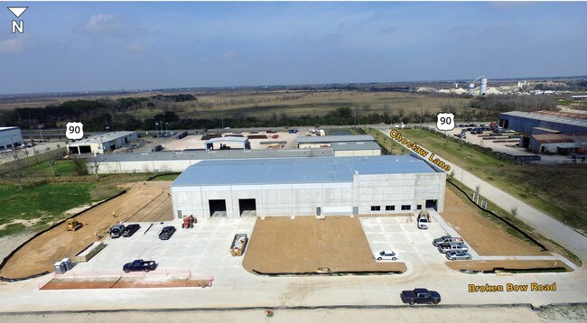
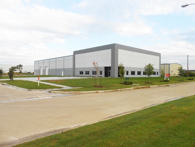
Property Record
633 Choctaw Ln, Katy, TX 77494

Property Detail
633 Choctaw Ln
Houston-Pasadena-The Woodlands, TX
S889613 WEST TEN BUS PARK COMM RES PART REP 1 ACRES 1.6 REST RES B
255050
WALLER
Commercialnec
Texas
B and X Area of moderate flood hazard, usually the area between the limits of the 100-year and 500-year floods.
resb
2024
1.60 AC
2025
Northwest Outliers
680100
Houston
22,375 SF
NEARBY LISTINGS FOR SALE OR LEASE
DEMOGRAPHICS near 633 Choctaw Ln
1 mile
3 mile
5 mile
2025 Total Population
1,016
49,323
168,454
2030 Population
1,174
56,197
190,613
Pop Growth 2025-2030
+ 15.55%
+ 13.94%
+ 13.15%
Average Age
35
36
35
2025 Total Households
305
15,371
53,052
HH Growth 2025-2030
+ 16.07%
+ 14.25%
+ 13.39%
Median Household Inc
$165,217
$144,808
$129,302
Avg Household Size
3.30
3.20
3.20
2025 Avg HH Vehicles
2.00
2.00
2.00
Median Home Value
$541,401
$484,630
$463,564
Median Year Built
2011
2011
2011
Nearby Places
Map Layers
Map Styles
 Street
 Aerial
Layers
 Traffic
 Biking
Places
Listings with unknown addresses are not visible on the map
- Restaurants
- Banks
- Shops
- Fitness
- Groceries
PUBLIC TRANSPORTATION
AIRPORT
George Bush Intcntl/Houston
Drive
Walk
Distance
George Bush Intcntl/Houston
58 min
44.9 mi
Freight Ports
Port of Houston
Drive
Walk
Distance
Port of Houston
57 min
40.4 mi
SALE & LEASE HISTORY
LISTING DATE
SALE/LEASE

Sep 25, 2016
For Lease
Sep 23, 2016
For Sale
May 08, 2017
For Lease
May 08, 2017
For Sale
Nearby Properties
Address
Land Use
TOTAL SIZE
Lot Size
Zoning
Address
Land Use
TOTAL SIZE
Lot Size
Zoning
1,655,920 SF
121.35 AC
Address
Land Use
TOTAL SIZE
Lot Size
Zoning
720,217 SF
65.17 AC
Address
Land Use
TOTAL SIZE
Lot Size
Zoning
1,300,000 SF
60.33 AC
Address
Land Use
TOTAL SIZE
Lot Size
Zoning
185,815 SF
30.28 AC
Address
Land Use
TOTAL SIZE
Lot Size
Zoning
Address
Land Use
TOTAL SIZE
Lot Size
Zoning
16.46 AC
Address
Land Use
TOTAL SIZE
Lot Size
Zoning
910,296 SF
50.41 AC
Address
Land Use
TOTAL SIZE
Lot Size
Zoning
678,028 SF
42.63 AC
Address
Land Use
TOTAL SIZE
Lot Size
Zoning
Address
Land Use
TOTAL SIZE
Lot Size
Zoning
148,600 SF
14.61 AC
Address
Land Use
TOTAL SIZE
Lot Size
Zoning
29.37 AC
Address
Land Use
TOTAL SIZE
Lot Size
Zoning
20.05 AC
SYQ
Address
Land Use
TOTAL SIZE
Lot Size
Zoning
505,690 SF
26.46 AC
Address
Land Use
TOTAL SIZE
Lot Size
Zoning
51,600 SF
19.66 AC
Address
Land Use
TOTAL SIZE
Lot Size
Zoning
108,600 SF
9.08 AC
Address
Land Use
TOTAL SIZE
Lot Size
Zoning
510,614 SF
56.19 AC
Address
Land Use
TOTAL SIZE
Lot Size
Zoning
12.71 AC
Address
Land Use
TOTAL SIZE
Lot Size
Zoning
411,920 SF
22.31 AC
Address
Land Use
TOTAL SIZE
Lot Size
Zoning
168,025 SF
13.55 AC
Address
Land Use
TOTAL SIZE
Lot Size
Zoning
510,020 SF
7.29 AC
Address
Land Use
TOTAL SIZE
Lot Size
Zoning
419,840 SF
31.94 AC
Address
Land Use
TOTAL SIZE
Lot Size
Zoning
15.54 AC
Address
Land Use
TOTAL SIZE
Lot Size
Zoning
72,499 SF
11.18 AC
XQ
Address
Land Use
TOTAL SIZE
Lot Size
Zoning
58,275 SF
8.15 AC
QSY
Address
Land Use
TOTAL SIZE
Lot Size
Zoning
123,086 SF
13.49 AC
Address
Land Use
TOTAL SIZE
Lot Size
Zoning
342,360 SF
22.75 AC
Address
Land Use
TOTAL SIZE
Lot Size
Zoning
326,364 SF
17.39 AC
Address
Land Use
TOTAL SIZE
Lot Size
Zoning
237,584 SF
27.48 AC
Address
Land Use
TOTAL SIZE
Lot Size
Zoning
150,548 SF
12.71 AC
Address
Land Use
TOTAL SIZE
Lot Size
Zoning
122,038 SF
8 AC
QS
The World's #1 Commercial Real Estate Marketplace
Connect with us
© 2026 CoStar Group
The information above has been obtained from sources believed reliable. While we do not doubt its accuracy we have not verified it and make no guarantee, warranty or representation about it. It is your responsibility to independently confirm its accuracy and completeness. Any projections, opinions, assumptions, or estimates used are for example only and do not represent the current or future performance of the property. The value of this transaction to you depends on tax and other factors which should be evaluated by your tax, financial, and legal advisors. You and your advisors should conduct a careful, independent investigation of the property to determine to your satisfaction the suitability of the property for your needs.