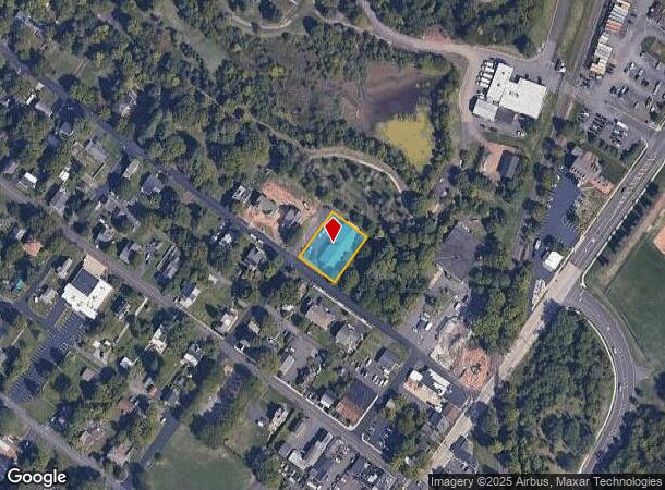
Property Record
633 Jones Ave, Lansdale, PA 19446
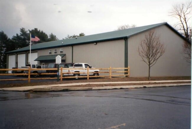
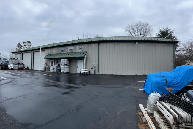
This Property Is For Sale
NEARBY LISTINGS FOR SALE OR LEASE
Property Detail
633 Jones Ave
Philadelphia-Camden-Wilmington, PA-NJ-DE-MD
Jones Farm
56-00-04465-006
117 X IRR 17500 SF
Commercialnec
Montgomery
X
Pennsylvania
42091C0258G
5
2024
0.40 AC
2025
East Montgomery Cty
200907
Philadelphia
6,488 SF
DEMOGRAPHICS near 633 Jones Ave
1 Mile
3 Mile
5 Mile
2024 Total Population
4,891
61,980
147,848
2029 Population
4,927
62,777
150,339
Pop Growth 2024-2029
+ 0.74%
+ 1.29%
+ 1.68%
Average Age
46
43
44
2024 Total Households
1,929
24,368
57,335
HH Growth 2024-2029
+ 0.78%
+ 1.21%
+ 1.62%
Median Household Inc
$131,106
$107,491
$109,088
Avg Household Size
2.50
2.40
2.50
2024 Avg HH Vehicles
2.00
2.00
2.00
Median Home Value
$482,025
$406,757
$402,467
Median Year Built
1984
1975
1979
Nearby Places
Map Layers
Map Styles
 Street
 Aerial
- Restaurants
- Banks
- Shops
- Fitness
- Groceries
PUBLIC TRANSPORTATION
COMMUTER RAIL
North Wales (R5 - Southeastern Pennsylvania Transportation Authority Regional Rail (SEPTA Regional Rail))
DRIVE
WALK
Distance
North Wales (R5 - Southeastern Pennsylvania Transportation Authority Regional Rail (SEPTA Regional Rail))
5 min
2.1 mi
Pennbrook (R5 - Southeastern Pennsylvania Transportation Authority Regional Rail (SEPTA Regional Rail))
DRIVE
WALK
Distance
Pennbrook (R5 - Southeastern Pennsylvania Transportation Authority Regional Rail (SEPTA Regional Rail))
5 min
2.1 mi
AIRPORT
Philadelphia International
DRIVE
WALK
Distance
Philadelphia International
51 min
35.5 mi
Trenton Mercer
DRIVE
WALK
Distance
Trenton Mercer
57 min
39.3 mi
Freight Ports
Port of Philadelphia
DRIVE
WALK
Distance
Port of Philadelphia
39 min
23.5 mi
Nearby Properties
Address
Land Use
TOTAL SIZE
Lot Size
Zoning
Address
Land Use
TOTAL SIZE
Lot Size
Zoning
7,622,512 SF
315.44 AC
LI
Address
Land Use
TOTAL SIZE
Lot Size
Zoning
1,744,364 SF
91.78 AC
LI
Address
Land Use
TOTAL SIZE
Lot Size
Zoning
688,123 SF
190.06 AC
IN
Address
Land Use
TOTAL SIZE
Lot Size
Zoning
720,767 SF
118.21 AC
AGR
Address
Land Use
TOTAL SIZE
Lot Size
Zoning
519,907 SF
91.44 AC
R125
Address
Land Use
TOTAL SIZE
Lot Size
Zoning
404,986 SF
22.21 AC
I
Address
Land Use
TOTAL SIZE
Lot Size
Zoning
610,455 SF
103.65 AC
R6
Address
Land Use
TOTAL SIZE
Lot Size
Zoning
629,336 SF
31.74 AC
IN
Address
Land Use
TOTAL SIZE
Lot Size
Zoning
268,288 SF
30.59 AC
RA
Address
Land Use
TOTAL SIZE
Lot Size
Zoning
444,426 SF
30 AC
GA
Address
Land Use
TOTAL SIZE
Lot Size
Zoning
657,589 SF
100.81 AC
MF3A
Address
Land Use
TOTAL SIZE
Lot Size
Zoning
225,154 SF
6.38 AC
B
Address
Land Use
TOTAL SIZE
Lot Size
Zoning
703,182 SF
84.25 AC
LI
Address
Land Use
TOTAL SIZE
Lot Size
Zoning
139,081 SF
15.20 AC
LI
Address
Land Use
TOTAL SIZE
Lot Size
Zoning
337,074 SF
12.92 AC
A
Address
Land Use
TOTAL SIZE
Lot Size
Zoning
289,681 SF
4.75 AC
BPO
Address
Land Use
TOTAL SIZE
Lot Size
Zoning
191,042 SF
9.59 AC
R6
Address
Land Use
TOTAL SIZE
Lot Size
Zoning
233,730 SF
19.10 AC
GA
Address
Land Use
TOTAL SIZE
Lot Size
Zoning
216,017 SF
16 AC
GA
Address
Land Use
TOTAL SIZE
Lot Size
Zoning
207,306 SF
14.50 AC
GA
Address
Land Use
TOTAL SIZE
Lot Size
Zoning
135,540 SF
27.77 AC
A1
Address
Land Use
TOTAL SIZE
Lot Size
Zoning
125,704 SF
25 AC
R2
Address
Land Use
TOTAL SIZE
Lot Size
Zoning
87,170 SF
10.23 AC
RA
Address
Land Use
TOTAL SIZE
Lot Size
Zoning
153,873 SF
48.98 AC
R2
Address
Land Use
TOTAL SIZE
Lot Size
Zoning
233,964 SF
8.05 AC
B
Address
Land Use
TOTAL SIZE
Lot Size
Zoning
68,442 SF
12.22 AC
AGR
Address
Land Use
TOTAL SIZE
Lot Size
Zoning
77,875 SF
18.59 AC
RA
Address
Land Use
TOTAL SIZE
Lot Size
Zoning
148,455 SF
17.56 AC
I
Address
Land Use
TOTAL SIZE
Lot Size
Zoning
145,046 SF
3.09 AC
I
Address
Land Use
TOTAL SIZE
Lot Size
Zoning
648,406 SF
43.51 AC
OC
The World's #1 Commercial Real Estate Marketplace
Connect with us
© 2025 CoStar Group
The information above has been obtained from sources believed reliable. While we do not doubt its accuracy we have not verified it and make no guarantee, warranty or representation about it. It is your responsibility to independently confirm its accuracy and completeness. Any projections, opinions, assumptions, or estimates used are for example only and do not represent the current or future performance of the property. The value of this transaction to you depends on tax and other factors which should be evaluated by your tax, financial, and legal advisors. You and your advisors should conduct a careful, independent investigation of the property to determine to your satisfaction the suitability of the property for your needs.