Property Record
633 Saco Lowell Rd, Easley, SC 29640
NEARBY LISTINGS FOR SALE OR LEASE
Property Detail
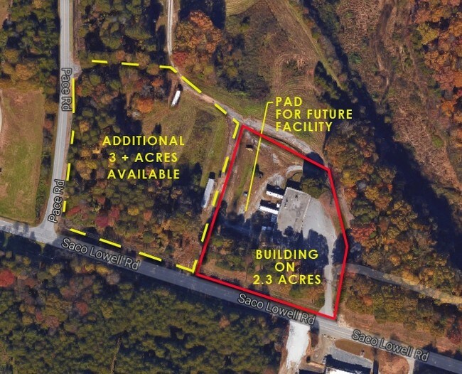
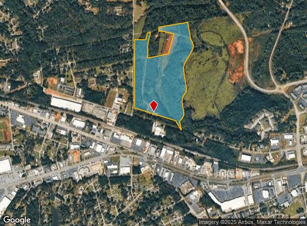
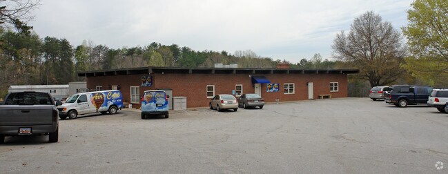
633 Saco Lowell Rd
Greenville-Anderson-Mauldin, SC
N/SIDE SACO LOWELL RD PLAT 604/97
5039-13-04-8790
Pickens
Officebuilding
South Carolina
2025
61.50 AC
2024
Outlying Pickens Co
010802
Greenville/Spartanburg
5,712 SF
DEMOGRAPHICS near 633 Saco Lowell Rd
1 Mile
3 Mile
5 Mile
2024 Total Population
4,117
29,291
56,506
2029 Population
4,272
30,685
59,297
Pop Growth 2024-2029
+ 3.76%
+ 4.76%
+ 4.94%
Average Age
42
42
41
2024 Total Households
1,853
12,294
22,506
HH Growth 2024-2029
+ 3.78%
+ 4.82%
+ 4.99%
Median Household Inc
$56,166
$55,581
$58,020
Avg Household Size
2.20
2.30
2.50
2024 Avg HH Vehicles
2.00
2.00
2.00
Median Home Value
$233,333
$190,111
$191,261
Median Year Built
1990
1989
1989
Nearby Places
Map Layers
Map Styles
 Street
 Aerial
- Restaurants
- Banks
- Shops
- Fitness
- Groceries
PUBLIC TRANSPORTATION
AIRPORT
Greenville Spartanburg International
DRIVE
WALK
Distance
Greenville Spartanburg International
38 min
26.0 mi
SALE & LEASE HISTORY
LISTING DATE
SALE/LEASE

Sep 25, 2016
For Lease
Sep 24, 2016
For Sale
Oct 19, 2018
For Sale
Nov 14, 2018
For Lease
Nearby Properties
Address
Land Use
TOTAL SIZE
Lot Size
Zoning
Address
Land Use
TOTAL SIZE
Lot Size
Zoning
2,291 SF
6.44 AC
GR2
Address
Land Use
TOTAL SIZE
Lot Size
Zoning
81,245 SF
8.49 AC
GC
Address
Land Use
TOTAL SIZE
Lot Size
Zoning
162.06 AC
R10
Address
Land Use
TOTAL SIZE
Lot Size
Zoning
16.29 AC
GENERAL CO
Address
Land Use
TOTAL SIZE
Lot Size
Zoning
10,906 SF
2.59 AC
CORE COMME
Address
Land Use
TOTAL SIZE
Lot Size
Zoning
19,164 SF
3.22 AC
GC
Address
Land Use
TOTAL SIZE
Lot Size
Zoning
13.75 AC
GC
Address
Land Use
TOTAL SIZE
Lot Size
Zoning
24,362 SF
3.84 AC
GENERAL CO
Address
Land Use
TOTAL SIZE
Lot Size
Zoning
21.71 AC
GR2
Address
Land Use
TOTAL SIZE
Lot Size
Zoning
3,344 SF
3.04 AC
GR2
Address
Land Use
TOTAL SIZE
Lot Size
Zoning
9,800 SF
5.94 AC
R10
Address
Land Use
TOTAL SIZE
Lot Size
Zoning
3.60 AC
CORE COMME
Address
Land Use
TOTAL SIZE
Lot Size
Zoning
49,803 SF
18.36 AC
GC
Address
Land Use
TOTAL SIZE
Lot Size
Zoning
4,200 SF
0.98 AC
GC
Address
Land Use
TOTAL SIZE
Lot Size
Zoning
220,956 SF
16.80 AC
GENERAL CO
Address
Land Use
TOTAL SIZE
Lot Size
Zoning
36.37 AC
Address
Land Use
TOTAL SIZE
Lot Size
Zoning
20,406 SF
1.26 AC
CORE COMME
Address
Land Use
TOTAL SIZE
Lot Size
Zoning
5,321 SF
3.38 AC
Address
Land Use
TOTAL SIZE
Lot Size
Zoning
5,427 SF
1.34 AC
Address
Land Use
TOTAL SIZE
Lot Size
Zoning
8.96 AC
R 10 ONE F
Address
Land Use
TOTAL SIZE
Lot Size
Zoning
7.30 AC
R 10 ONE F
Address
Land Use
TOTAL SIZE
Lot Size
Zoning
187,150 SF
19.38 AC
GC
Address
Land Use
TOTAL SIZE
Lot Size
Zoning
4,450 SF
1.28 AC
MED MEDICA
Address
Land Use
TOTAL SIZE
Lot Size
Zoning
27.43 AC
R 10 ONE F
Address
Land Use
TOTAL SIZE
Lot Size
Zoning
42.26 AC
OFFICE INS
Address
Land Use
TOTAL SIZE
Lot Size
Zoning
7.09 AC
GC
Address
Land Use
TOTAL SIZE
Lot Size
Zoning
21,258 SF
15 AC
GR2
Address
Land Use
TOTAL SIZE
Lot Size
Zoning
135,439 SF
13.80 AC
GC
Address
Land Use
TOTAL SIZE
Lot Size
Zoning
41.39 AC
The World's #1 Commercial Real Estate Marketplace
Connect with us
© 2025 CoStar Group
The information above has been obtained from sources believed reliable. While we do not doubt its accuracy we have not verified it and make no guarantee, warranty or representation about it. It is your responsibility to independently confirm its accuracy and completeness. Any projections, opinions, assumptions, or estimates used are for example only and do not represent the current or future performance of the property. The value of this transaction to you depends on tax and other factors which should be evaluated by your tax, financial, and legal advisors. You and your advisors should conduct a careful, independent investigation of the property to determine to your satisfaction the suitability of the property for your needs.