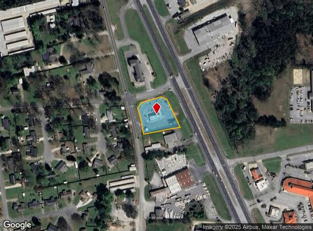
Property Record
6330 Highway 69 S, Tuscaloosa, AL 35405
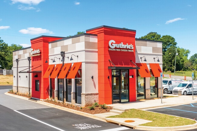
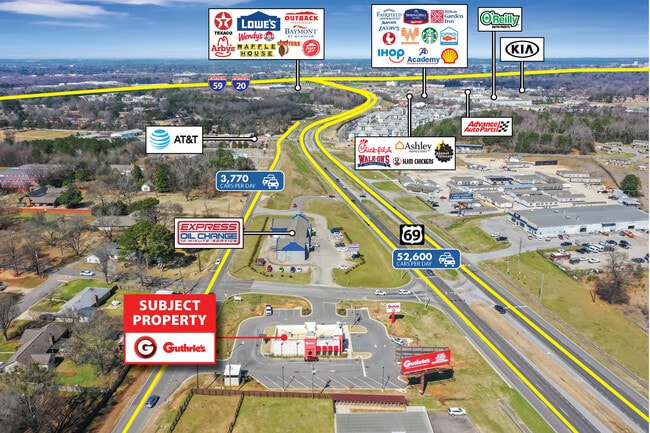
This Property Is For Sale
NEARBY LISTINGS FOR SALE OR LEASE
Property Detail
6330 Highway 69 S
36-01-11-1-004-003.005
COM NE COR S11 T22S R10W TH W 1165(S); S 1527(S) TO POB TH NW 41(S); SW 134(S); SW 38(S); SE 173(S); NE 239.6 TO POB
Restaurantdrivein
Tuscaloosa
X
Alabama
01125C0518G
1 AC
2025
Tuscaloosa
2024
Birmingham
012403
Tuscaloosa, AL
DEMOGRAPHICS near 6330 Highway 69 S
1 Mile
3 Mile
5 Mile
2024 Total Population
4,989
37,621
114,110
2029 Population
5,569
42,406
128,385
Pop Growth 2024-2029
+ 11.63%
+ 12.72%
+ 12.51%
Average Age
36
36
33
2024 Total Households
2,184
16,662
43,357
HH Growth 2024-2029
+ 10.49%
+ 12.24%
+ 14.33%
Median Household Inc
$65,725
$48,796
$40,459
Avg Household Size
2.20
2.20
2.10
2024 Avg HH Vehicles
2.00
2.00
2.00
Median Home Value
$170,510
$188,384
$191,941
Median Year Built
1990
1992
1991
Nearby Places
- Restaurants
- Banks
- Shops
- Fitness
- Groceries
PUBLIC TRANSPORTATION
COMMUTER RAIL
Tuscaloosa Amtrak Station (Crescent - Amtrak)
DRIVE
WALK
Distance
Tuscaloosa Amtrak Station (Crescent - Amtrak)
6 min
3.5 mi
Freight Ports
Port of Mobile
DRIVE
WALK
Distance
Port of Mobile
235 min
191.0 mi
Nearby Properties
Address
Land Use
TOTAL SIZE
Lot Size
Zoning
Address
Land Use
TOTAL SIZE
Lot Size
Zoning
11,278 SF
145 AC
R3
Address
Land Use
TOTAL SIZE
Lot Size
Zoning
9,258 SF
19 AC
R4
Address
Land Use
TOTAL SIZE
Lot Size
Zoning
25,920 SF
16 AC
RMF1
Address
Land Use
TOTAL SIZE
Lot Size
Zoning
11,804 SF
76 AC
Address
Land Use
TOTAL SIZE
Lot Size
Zoning
13,804 SF
17.76 AC
Address
Land Use
TOTAL SIZE
Lot Size
Zoning
5,377 SF
22 AC
RMF1
Address
Land Use
TOTAL SIZE
Lot Size
Zoning
9,328 SF
19 AC
RMF1
Address
Land Use
TOTAL SIZE
Lot Size
Zoning
1,088 SF
17 AC
R4
Address
Land Use
TOTAL SIZE
Lot Size
Zoning
12 AC
R1
Address
Land Use
TOTAL SIZE
Lot Size
Zoning
16,000 SF
12 AC
RMF1
Address
Land Use
TOTAL SIZE
Lot Size
Zoning
15,912 SF
22 AC
Address
Land Use
TOTAL SIZE
Lot Size
Zoning
193,154 SF
20 AC
BN
Address
Land Use
TOTAL SIZE
Lot Size
Zoning
68,796 SF
11.30 AC
MG
Address
Land Use
TOTAL SIZE
Lot Size
Zoning
16,536 SF
15.96 AC
R4
Address
Land Use
TOTAL SIZE
Lot Size
Zoning
8,960 SF
19 AC
R4
Address
Land Use
TOTAL SIZE
Lot Size
Zoning
7,536 SF
11 AC
R4
Address
Land Use
TOTAL SIZE
Lot Size
Zoning
18,828 SF
5 AC
R2
Address
Land Use
TOTAL SIZE
Lot Size
Zoning
314,500 SF
9.97 AC
MG
Address
Land Use
TOTAL SIZE
Lot Size
Zoning
2,090 SF
9.49 AC
Address
Land Use
TOTAL SIZE
Lot Size
Zoning
25,920 SF
4 AC
RMF1
Address
Land Use
TOTAL SIZE
Lot Size
Zoning
1,972 SF
8 AC
Address
Land Use
TOTAL SIZE
Lot Size
Zoning
4,620 SF
12.55 AC
R4
Address
Land Use
TOTAL SIZE
Lot Size
Zoning
5,508 SF
0.14 AC
RM2
Address
Land Use
TOTAL SIZE
Lot Size
Zoning
100,000 SF
27.22 AC
MG
Address
Land Use
TOTAL SIZE
Lot Size
Zoning
1,816 SF
5.30 AC
Address
Land Use
TOTAL SIZE
Lot Size
Zoning
6,992 SF
13 AC
RMF1
Address
Land Use
TOTAL SIZE
Lot Size
Zoning
20.27 AC
Address
Land Use
TOTAL SIZE
Lot Size
Zoning
8,000 SF
8.30 AC
R4
Address
Land Use
TOTAL SIZE
Lot Size
Zoning
206,739 SF
22.69 AC
BN
Address
Land Use
TOTAL SIZE
Lot Size
Zoning
22,672 SF
13 AC
R4
The World's #1 Commercial Real Estate Marketplace
Connect with us
© 2025 CoStar Group
The information above has been obtained from sources believed reliable. While we do not doubt its accuracy we have not verified it and make no guarantee, warranty or representation about it. It is your responsibility to independently confirm its accuracy and completeness. Any projections, opinions, assumptions, or estimates used are for example only and do not represent the current or future performance of the property. The value of this transaction to you depends on tax and other factors which should be evaluated by your tax, financial, and legal advisors. You and your advisors should conduct a careful, independent investigation of the property to determine to your satisfaction the suitability of the property for your needs.