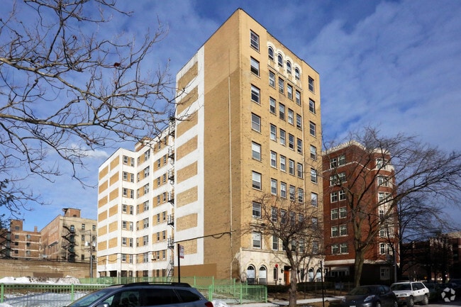
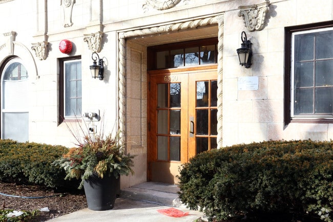
Property Record
6332 N Winthrop Ave, Chicago, IL 60660

NEARBY LISTINGS FOR SALE OR LEASE
Property Detail
6332 N Winthrop Ave
Chicago-Naperville-Elgin, IL-IN-WI
Cochrans 2Nd Add To Edgewater
14-05-200-019-0000
(COCHRANS)(2ND) ADD TO (EDGEWATER) IN EH SEC 05-40-14
Taxexempt
Cook
X
Illinois
17031C0406K
6
2021
0.16 AC
2025
Edgewater
030104
Chicago
DEMOGRAPHICS near 6332 N Winthrop Ave
1 Mile
3 Mile
5 Mile
2024 Total Population
67,590
325,618
681,738
2029 Population
65,894
315,873
658,926
Pop Growth 2024-2029
(2.51%)
(2.99%)
(3.35%)
Average Age
39
39
38
2024 Total Households
34,573
150,081
306,939
HH Growth 2024-2029
(2.71%)
(3.24%)
(3.52%)
Median Household Inc
$53,890
$64,789
$78,380
Avg Household Size
1.80
2.00
2.10
2024 Avg HH Vehicles
1.00
1.00
1.00
Median Home Value
$282,832
$345,067
$404,121
Median Year Built
1949
1948
1950
Nearby Places
Map Layers
Map Styles
 Street
 Aerial
- Restaurants
- Banks
- Shops
- Fitness
- Groceries
PUBLIC TRANSPORTATION
TRANSIT/SUBWAY
Granville Station (Red Line - Chicago Transit Authority "L" Trains (The "L"))
DRIVE
WALK
Distance
Granville Station (Red Line - Chicago Transit Authority "L" Trains (The "L"))
1 min
5 min
0.3 mi
Loyola Station (Red Line - Chicago Transit Authority "L" Trains (The "L"))
DRIVE
WALK
Distance
Loyola Station (Red Line - Chicago Transit Authority "L" Trains (The "L"))
3 min
6 min
0.3 mi
Thorndale Station (Red Line - Chicago Transit Authority "L" Trains (The "L"))
DRIVE
WALK
Distance
Thorndale Station (Red Line - Chicago Transit Authority "L" Trains (The "L"))
2 min
10 min
0.5 mi
Bryn Mawr Station (Red Line - Chicago Transit Authority "L" Trains (The "L"))
DRIVE
WALK
Distance
Bryn Mawr Station (Red Line - Chicago Transit Authority "L" Trains (The "L"))
2 min
19 min
1.0 mi
COMMUTER RAIL
Peterson/Ridge (Union Pacific North - Metra)
DRIVE
WALK
Distance
Peterson/Ridge (Union Pacific North - Metra)
3 min
1.3 mi
Rogers Park Station (Union Pacific North Line - Northeast Illinois Regional Commuter Railroad (Metra))
DRIVE
WALK
Distance
Rogers Park Station (Union Pacific North Line - Northeast Illinois Regional Commuter Railroad (Metra))
6 min
2.2 mi
AIRPORT
Chicago O'Hare International
DRIVE
WALK
Distance
Chicago O'Hare International
27 min
14.4 mi
Chicago Midway International
DRIVE
WALK
Distance
Chicago Midway International
30 min
20.6 mi
Freight Ports
Port Milwaukee
DRIVE
WALK
Distance
Port Milwaukee
99 min
78.2 mi
Nearby Properties
Address
Land Use
TOTAL SIZE
Lot Size
Zoning
Address
Land Use
TOTAL SIZE
Lot Size
Zoning
0.63 AC
PD 1372
Address
Land Use
TOTAL SIZE
Lot Size
Zoning
305,592 SF
27.35 AC
Address
Land Use
TOTAL SIZE
Lot Size
Zoning
301,100 SF
2.20 AC
PD 37
Address
Land Use
TOTAL SIZE
Lot Size
Zoning
1 AC
RS-3
Address
Land Use
TOTAL SIZE
Lot Size
Zoning
147,835 SF
1.03 AC
PD 37
Address
Land Use
TOTAL SIZE
Lot Size
Zoning
71,400 SF
0.95 AC
RT-4,B3-2
Address
Land Use
TOTAL SIZE
Lot Size
Zoning
201,600 SF
1.93 AC
PD 92
Address
Land Use
TOTAL SIZE
Lot Size
Zoning
63,700 SF
7.42 AC
PD 796
Address
Land Use
TOTAL SIZE
Lot Size
Zoning
17,594 SF
0.11 AC
B2-5
Address
Land Use
TOTAL SIZE
Lot Size
Zoning
226,345 SF
3.71 AC
PD 1203
Address
Land Use
TOTAL SIZE
Lot Size
Zoning
197,785 SF
4.03 AC
PD 943
Address
Land Use
TOTAL SIZE
Lot Size
Zoning
32,200 SF
5.67 AC
B3-5,RM-6.
Address
Land Use
TOTAL SIZE
Lot Size
Zoning
34,600 SF
0.57 AC
B3-5
Address
Land Use
TOTAL SIZE
Lot Size
Zoning
24,400 SF
0.50 AC
B3-2
Address
Land Use
TOTAL SIZE
Lot Size
Zoning
223,366 SF
0.65 AC
Address
Land Use
TOTAL SIZE
Lot Size
Zoning
83,966 SF
0.76 AC
RM-5.5
Address
Land Use
TOTAL SIZE
Lot Size
Zoning
1.01 AC
RM-6,POS-1
Address
Land Use
TOTAL SIZE
Lot Size
Zoning
41,361 SF
0.77 AC
RS-3
Address
Land Use
TOTAL SIZE
Lot Size
Zoning
72,503 SF
5.60 AC
Address
Land Use
TOTAL SIZE
Lot Size
Zoning
119,468 SF
0.57 AC
Address
Land Use
TOTAL SIZE
Lot Size
Zoning
229,540 SF
8.23 AC
Address
Land Use
TOTAL SIZE
Lot Size
Zoning
47,014 SF
0.57 AC
B3-2
Address
Land Use
TOTAL SIZE
Lot Size
Zoning
145,031 SF
1.90 AC
PD 372
Address
Land Use
TOTAL SIZE
Lot Size
Zoning
0.23 AC
B3-3
Address
Land Use
TOTAL SIZE
Lot Size
Zoning
70,792 SF
1.40 AC
PD 631
Address
Land Use
TOTAL SIZE
Lot Size
Zoning
119,717 SF
0.70 AC
Address
Land Use
TOTAL SIZE
Lot Size
Zoning
128,200 SF
0.34 AC
B3-5
Address
Land Use
TOTAL SIZE
Lot Size
Zoning
299,157 SF
5.51 AC
Address
Land Use
TOTAL SIZE
Lot Size
Zoning
1.20 AC
PD 92
The World's #1 Commercial Real Estate Marketplace
Connect with us
© 2025 CoStar Group
The information above has been obtained from sources believed reliable. While we do not doubt its accuracy we have not verified it and make no guarantee, warranty or representation about it. It is your responsibility to independently confirm its accuracy and completeness. Any projections, opinions, assumptions, or estimates used are for example only and do not represent the current or future performance of the property. The value of this transaction to you depends on tax and other factors which should be evaluated by your tax, financial, and legal advisors. You and your advisors should conduct a careful, independent investigation of the property to determine to your satisfaction the suitability of the property for your needs.