Property Record
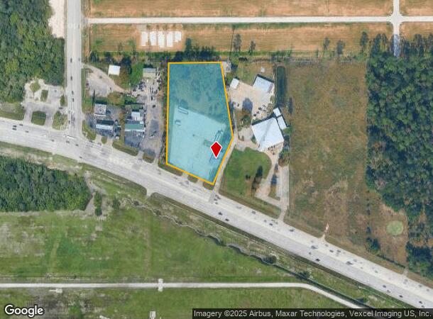
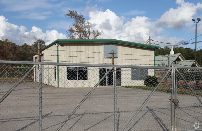
6333 Fm 1960 Rd W, Humble, TX 77338

NEARBY LISTINGS FOR SALE OR LEASE
Property Detail
6333 Fm 1960 Rd W
0450240020062
Abst 720 J Skorupski
Warehouse
TR 62A ABST 720 J SKORUPSKI
X
Harris
48339C0725G
Texas
2024
3.44 AC
2025
Spring Creek
240905
Houston
3,000 SF
Houston-The Woodlands-Sugar Land, TX
DEMOGRAPHICS near 6333 Fm 1960 Rd W
1 Mile
3 Mile
5 Mile
2024 Total Population
6,944
39,297
112,200
2029 Population
7,164
40,040
114,913
Pop Growth 2024-2029
+ 3.17%
+ 1.89%
+ 2.42%
Average Age
35
35
35
2024 Total Households
2,188
12,596
35,951
HH Growth 2024-2029
+ 3.15%
+ 1.87%
+ 2.43%
Median Household Inc
$77,366
$67,533
$63,369
Avg Household Size
3.20
3.00
3.00
2024 Avg HH Vehicles
2.00
2.00
2.00
Median Home Value
$173,717
$166,316
$166,789
Median Year Built
2004
2000
1995
Nearby Places
Map Layers
Map Styles
 Street
 Aerial
- Restaurants
- Banks
- Shops
- Fitness
- Groceries
PUBLIC TRANSPORTATION
AIRPORT
George Bush Intcntl/Houston
DRIVE
WALK
Distance
George Bush Intcntl/Houston
14 min
7.4 mi
William P Hobby
DRIVE
WALK
Distance
William P Hobby
51 min
33.2 mi
Freight Ports
Port of Houston
DRIVE
WALK
Distance
Port of Houston
40 min
26.9 mi
Nearby Properties
Address
Land Use
TOTAL SIZE
Lot Size
Zoning
Address
Land Use
TOTAL SIZE
Lot Size
Zoning
429,750 SF
24.74 AC
Address
Land Use
TOTAL SIZE
Lot Size
Zoning
391,060 SF
32.42 AC
Address
Land Use
TOTAL SIZE
Lot Size
Zoning
355,622 SF
15.78 AC
Address
Land Use
TOTAL SIZE
Lot Size
Zoning
432,617 SF
19.41 AC
Address
Land Use
TOTAL SIZE
Lot Size
Zoning
334,510 SF
23.54 AC
Address
Land Use
TOTAL SIZE
Lot Size
Zoning
235,236 SF
15.14 AC
Address
Land Use
TOTAL SIZE
Lot Size
Zoning
309,744 SF
21.50 AC
Address
Land Use
TOTAL SIZE
Lot Size
Zoning
216,978 SF
10.99 AC
Address
Land Use
TOTAL SIZE
Lot Size
Zoning
252,320 SF
22.14 AC
Address
Land Use
TOTAL SIZE
Lot Size
Zoning
205,040 SF
10.51 AC
Address
Land Use
TOTAL SIZE
Lot Size
Zoning
242,788 SF
14.72 AC
Address
Land Use
TOTAL SIZE
Lot Size
Zoning
199,368 SF
8.16 AC
Address
Land Use
TOTAL SIZE
Lot Size
Zoning
208,230 SF
14.79 AC
Address
Land Use
TOTAL SIZE
Lot Size
Zoning
165,737 SF
14 AC
Address
Land Use
TOTAL SIZE
Lot Size
Zoning
102,374 SF
13.48 AC
Address
Land Use
TOTAL SIZE
Lot Size
Zoning
206,600 SF
23.09 AC
Address
Land Use
TOTAL SIZE
Lot Size
Zoning
175,495 SF
8.92 AC
Address
Land Use
TOTAL SIZE
Lot Size
Zoning
168,400 SF
11.57 AC
Address
Land Use
TOTAL SIZE
Lot Size
Zoning
196,200 SF
16.86 AC
Address
Land Use
TOTAL SIZE
Lot Size
Zoning
162,738 SF
11.25 AC
Address
Land Use
TOTAL SIZE
Lot Size
Zoning
63,507 SF
2.83 AC
Address
Land Use
TOTAL SIZE
Lot Size
Zoning
159,480 SF
12.23 AC
Address
Land Use
TOTAL SIZE
Lot Size
Zoning
150,000 SF
13.09 AC
Address
Land Use
TOTAL SIZE
Lot Size
Zoning
133,700 SF
12.82 AC
Address
Land Use
TOTAL SIZE
Lot Size
Zoning
96,875 SF
8.09 AC
Address
Land Use
TOTAL SIZE
Lot Size
Zoning
146,503 SF
6.12 AC
Address
Land Use
TOTAL SIZE
Lot Size
Zoning
125,674 SF
11.56 AC
Address
Land Use
TOTAL SIZE
Lot Size
Zoning
136,154 SF
15.33 AC
Address
Land Use
TOTAL SIZE
Lot Size
Zoning
152,440 SF
24.67 AC
Address
Land Use
TOTAL SIZE
Lot Size
Zoning
106,901 SF
6.70 AC
The World's #1 Commercial Real Estate Marketplace
Connect with us
© 2025 CoStar Group
The information above has been obtained from sources believed reliable. While we do not doubt its accuracy we have not verified it and make no guarantee, warranty or representation about it. It is your responsibility to independently confirm its accuracy and completeness. Any projections, opinions, assumptions, or estimates used are for example only and do not represent the current or future performance of the property. The value of this transaction to you depends on tax and other factors which should be evaluated by your tax, financial, and legal advisors. You and your advisors should conduct a careful, independent investigation of the property to determine to your satisfaction the suitability of the property for your needs.