Property Record
6338 Oleander Dr, Wilmington, NC 28403

Property Detail
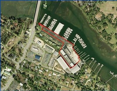
6338 Oleander Dr
R05620-004-001-000
BRADLEY CREEK HARNETT
Officebuilding
NEW HANOVER
CB,COMMUNI
North Carolina
VE and V1-30 Coastal areas with a 1% or greater chance of flooding and an additional hazard associated with storm waves. These areas have a 26% chance of flooding over the life of a 30-year mortgage.
1
2025
4.20 AC
2025
Midtown
012012
Wilmington
1,560 SF
Wilmington, NC
NEARBY LISTINGS FOR SALE OR LEASE
-
-
View all Wilmington listings for sale on LoopNet.com
DEMOGRAPHICS near 6338 Oleander Dr
1 mile
3 mile
5 mile
2025 Total Population
5,445
43,699
112,222
2030 Population
5,756
46,596
118,438
Pop Growth 2025-2030
+ 5.71%
+ 6.63%
+ 5.54%
Average Age
42
40
40
2025 Total Households
2,362
18,122
47,782
HH Growth 2025-2030
+ 5.84%
+ 7.32%
+ 5.86%
Median Household Inc
$101,466
$88,285
$82,763
Avg Household Size
2.30
2.10
2.20
2025 Avg HH Vehicles
2.00
2.00
2.00
Median Home Value
$568,673
$585,616
$414,374
Median Year Built
1993
1994
1992
Nearby Places
Map Layers
Map Styles
 Street
 Aerial
Layers
 Traffic
 Biking
Places
Listings with unknown addresses are not visible on the map
- Restaurants
- Banks
- Shops
- Fitness
- Groceries
PUBLIC TRANSPORTATION
AIRPORT
Wilmington International
Drive
Walk
Distance
Wilmington International
21 min
10.5 mi
Freight Ports
Port of Wilmington
Drive
Walk
Distance
Port of Wilmington
16 min
8.4 mi
Nearby Properties
Address
Land Use
TOTAL SIZE
Lot Size
Zoning
Address
Land Use
TOTAL SIZE
Lot Size
Zoning
18,848 SF
649.08 AC
O&I,OFFICE
Address
Land Use
TOTAL SIZE
Lot Size
Zoning
13,398 SF
15.67 AC
O&I,OFFICE
Address
Land Use
TOTAL SIZE
Lot Size
Zoning
35,600 SF
14.86 AC
CB,COMMUNI
Address
Land Use
TOTAL SIZE
Lot Size
Zoning
194,040 SF
7.74 AC
MX
Address
Land Use
TOTAL SIZE
Lot Size
Zoning
3,540 SF
25.10 AC
MX
Address
Land Use
TOTAL SIZE
Lot Size
Zoning
74,696 SF
4.39 AC
O&I,OFFICE
Address
Land Use
TOTAL SIZE
Lot Size
Zoning
186,960 SF
8.80 AC
O&I,OFFICE
Address
Land Use
TOTAL SIZE
Lot Size
Zoning
128,015 SF
6.91 AC
RB,REGIONA
Address
Land Use
TOTAL SIZE
Lot Size
Zoning
153,764 SF
22.87 AC
RB,REGIONA
Address
Land Use
TOTAL SIZE
Lot Size
Zoning
102,524 SF
2.88 AC
C-4,COMMER
Address
Land Use
TOTAL SIZE
Lot Size
Zoning
136,312 SF
4.11 AC
C-4,COMMER
Address
Land Use
TOTAL SIZE
Lot Size
Zoning
41,145 SF
13.58 AC
CB,COMMUNI
Address
Land Use
TOTAL SIZE
Lot Size
Zoning
2,112 SF
6.99 AC
C-3,COMMER
Address
Land Use
TOTAL SIZE
Lot Size
Zoning
101,003 SF
7.89 AC
MX
Address
Land Use
TOTAL SIZE
Lot Size
Zoning
2,016 SF
14.69 AC
G-1,OFFICE
Address
Land Use
TOTAL SIZE
Lot Size
Zoning
94,518 SF
13.73 AC
O&I,OFFICE
Address
Land Use
TOTAL SIZE
Lot Size
Zoning
1,656 SF
74.28 AC
R-15,RESID
Address
Land Use
TOTAL SIZE
Lot Size
Zoning
73,457 SF
6.77 AC
MX
Address
Land Use
TOTAL SIZE
Lot Size
Zoning
30,595 SF
4.12 AC
O&I,OFFICE
Address
Land Use
TOTAL SIZE
Lot Size
Zoning
66,622 SF
3.28 AC
MX
Address
Land Use
TOTAL SIZE
Lot Size
Zoning
93,059 SF
2.76 AC
MX
Address
Land Use
TOTAL SIZE
Lot Size
Zoning
4,674 SF
55.08 AC
MX
Address
Land Use
TOTAL SIZE
Lot Size
Zoning
95,303 SF
19.20 AC
O&I,OFFICE
Address
Land Use
TOTAL SIZE
Lot Size
Zoning
85,973 SF
10 AC
RB,REGIONA
Address
Land Use
TOTAL SIZE
Lot Size
Zoning
43,454 SF
5.80 AC
G-1,OFFICE
Address
Land Use
TOTAL SIZE
Lot Size
Zoning
11,000 SF
7.59 AC
RB,REGIONA
Address
Land Use
TOTAL SIZE
Lot Size
Zoning
15,370 SF
11.38 AC
MX
Address
Land Use
TOTAL SIZE
Lot Size
Zoning
3,427 SF
7.60 AC
G-1,OFFICE
Address
Land Use
TOTAL SIZE
Lot Size
Zoning
54,660 SF
3.32 AC
O&I,OFFICE
The World's #1 Commercial Real Estate Marketplace
Connect with us
© 2026 CoStar Group
The information above has been obtained from sources believed reliable. While we do not doubt its accuracy we have not verified it and make no guarantee, warranty or representation about it. It is your responsibility to independently confirm its accuracy and completeness. Any projections, opinions, assumptions, or estimates used are for example only and do not represent the current or future performance of the property. The value of this transaction to you depends on tax and other factors which should be evaluated by your tax, financial, and legal advisors. You and your advisors should conduct a careful, independent investigation of the property to determine to your satisfaction the suitability of the property for your needs.