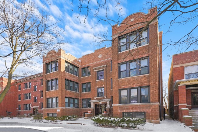
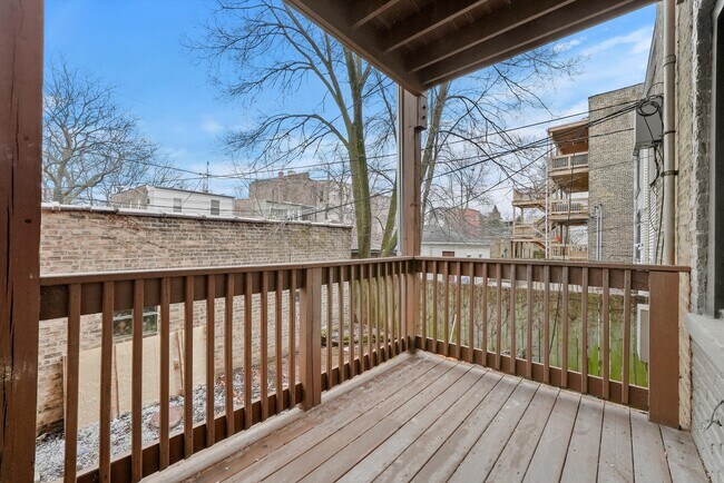
Property Record
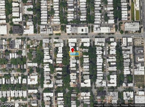
6341 N Wayne Ave S, Chicago, IL 60660

NEARBY LISTINGS FOR SALE OR LEASE
Property Detail
6341 N Wayne Ave S
Chicago-Naperville-Elgin, IL-IN-WI
Brockhausen & Fishers
14-05-105-003-0000
NORTH 60 RODS SEC05 E2NW4 S05 T40N R14E 3P
Apartment
Cook
X
Illinois
17031C0406K
33
2023
0.14 AC
2024
Edgewater
030200
Chicago
8,628 SF
DEMOGRAPHICS near 6341 N Wayne Ave S
1 Mile
3 Mile
5 Mile
2024 Total Population
78,930
340,709
701,422
2029 Population
77,028
330,375
677,794
Pop Growth 2024-2029
(2.41%)
(3.03%)
(3.37%)
Average Age
39
39
38
2024 Total Households
38,649
155,246
313,954
HH Growth 2024-2029
(2.64%)
(3.28%)
(3.55%)
Median Household Inc
$53,220
$65,205
$78,694
Avg Household Size
1.90
2.10
2.10
2024 Avg HH Vehicles
1.00
1.00
1.00
Median Home Value
$278,564
$349,070
$405,775
Median Year Built
1949
1948
1950
Nearby Places
Map Layers
Map Styles
 Street
 Aerial
- Restaurants
- Banks
- Shops
- Fitness
- Groceries
PUBLIC TRANSPORTATION
TRANSIT/SUBWAY
Loyola Station (Red Line - Chicago Transit Authority "L" Trains (The "L"))
DRIVE
WALK
Distance
Loyola Station (Red Line - Chicago Transit Authority "L" Trains (The "L"))
2 min
8 min
0.4 mi
Granville Station (Red Line - Chicago Transit Authority "L" Trains (The "L"))
DRIVE
WALK
Distance
Granville Station (Red Line - Chicago Transit Authority "L" Trains (The "L"))
2 min
9 min
0.5 mi
Thorndale Station (Red Line - Chicago Transit Authority "L" Trains (The "L"))
DRIVE
WALK
Distance
Thorndale Station (Red Line - Chicago Transit Authority "L" Trains (The "L"))
3 min
14 min
0.7 mi
Morse Station (Red Line - Chicago Transit Authority "L" Trains (The "L"))
DRIVE
WALK
Distance
Morse Station (Red Line - Chicago Transit Authority "L" Trains (The "L"))
4 min
19 min
1.0 mi
COMMUTER RAIL
DRIVE
WALK
Distance
3 min
20 min
1.0 mi
Rogers Park Station (Union Pacific North Line - Northeast Illinois Regional Commuter Railroad (Metra))
DRIVE
WALK
Distance
Rogers Park Station (Union Pacific North Line - Northeast Illinois Regional Commuter Railroad (Metra))
3 min
1.3 mi
AIRPORT
Chicago O'Hare International
DRIVE
WALK
Distance
Chicago O'Hare International
26 min
14.2 mi
Chicago Midway International
DRIVE
WALK
Distance
Chicago Midway International
31 min
21.0 mi
SALE & LEASE HISTORY
LISTING DATE
SALE/LEASE

Mar 10, 2023
For Sale
Nearby Properties
Address
Land Use
TOTAL SIZE
Lot Size
Zoning
Address
Land Use
TOTAL SIZE
Lot Size
Zoning
0.63 AC
PD 1372
Address
Land Use
TOTAL SIZE
Lot Size
Zoning
301,100 SF
2.20 AC
PD 37
Address
Land Use
TOTAL SIZE
Lot Size
Zoning
1 AC
RS-3
Address
Land Use
TOTAL SIZE
Lot Size
Zoning
305,592 SF
27.35 AC
Address
Land Use
TOTAL SIZE
Lot Size
Zoning
82,139 SF
4.88 AC
Address
Land Use
TOTAL SIZE
Lot Size
Zoning
892,012 SF
37.29 AC
Address
Land Use
TOTAL SIZE
Lot Size
Zoning
147,835 SF
1.03 AC
PD 37
Address
Land Use
TOTAL SIZE
Lot Size
Zoning
170,538 SF
0.76 AC
PD 112
Address
Land Use
TOTAL SIZE
Lot Size
Zoning
201,600 SF
1.93 AC
PD 92
Address
Land Use
TOTAL SIZE
Lot Size
Zoning
226,345 SF
3.71 AC
PD 1203
Address
Land Use
TOTAL SIZE
Lot Size
Zoning
197,785 SF
4.03 AC
PD 943
Address
Land Use
TOTAL SIZE
Lot Size
Zoning
32,200 SF
5.67 AC
B3-5,RM-6.
Address
Land Use
TOTAL SIZE
Lot Size
Zoning
63,700 SF
7.42 AC
PD 796
Address
Land Use
TOTAL SIZE
Lot Size
Zoning
24,400 SF
0.50 AC
B3-2
Address
Land Use
TOTAL SIZE
Lot Size
Zoning
1.01 AC
RM-6,POS-1
Address
Land Use
TOTAL SIZE
Lot Size
Zoning
0.16 AC
RM-6
Address
Land Use
TOTAL SIZE
Lot Size
Zoning
145,031 SF
1.90 AC
PD 372
Address
Land Use
TOTAL SIZE
Lot Size
Zoning
0.23 AC
B3-3
Address
Land Use
TOTAL SIZE
Lot Size
Zoning
223,366 SF
0.65 AC
Address
Land Use
TOTAL SIZE
Lot Size
Zoning
47,014 SF
0.57 AC
B3-2
Address
Land Use
TOTAL SIZE
Lot Size
Zoning
70,792 SF
1.40 AC
PD 631
Address
Land Use
TOTAL SIZE
Lot Size
Zoning
72,503 SF
5.60 AC
Address
Land Use
TOTAL SIZE
Lot Size
Zoning
1.20 AC
PD 92
Address
Land Use
TOTAL SIZE
Lot Size
Zoning
71,400 SF
0.95 AC
RT-4,B3-2
Address
Land Use
TOTAL SIZE
Lot Size
Zoning
0.76 AC
PD 37
Address
Land Use
TOTAL SIZE
Lot Size
Zoning
0.75 AC
PD 37
Address
Land Use
TOTAL SIZE
Lot Size
Zoning
135,464 SF
13.80 AC
Address
Land Use
TOTAL SIZE
Lot Size
Zoning
0.36 AC
B3-5
Address
Land Use
TOTAL SIZE
Lot Size
Zoning
200,952 SF
0.73 AC
PD 34
Address
Land Use
TOTAL SIZE
Lot Size
Zoning
128,433 SF
9.15 AC
The World's #1 Commercial Real Estate Marketplace
Connect with us
© 2025 CoStar Group
The information above has been obtained from sources believed reliable. While we do not doubt its accuracy we have not verified it and make no guarantee, warranty or representation about it. It is your responsibility to independently confirm its accuracy and completeness. Any projections, opinions, assumptions, or estimates used are for example only and do not represent the current or future performance of the property. The value of this transaction to you depends on tax and other factors which should be evaluated by your tax, financial, and legal advisors. You and your advisors should conduct a careful, independent investigation of the property to determine to your satisfaction the suitability of the property for your needs.