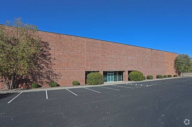
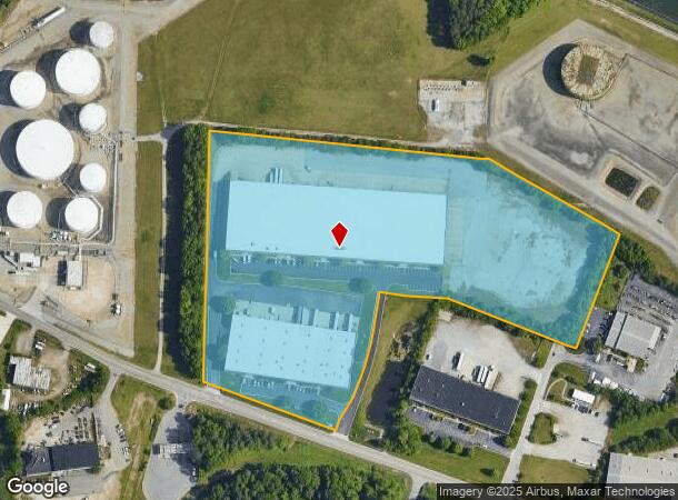
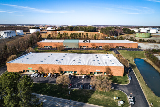
Property Record
6348 Burnt Poplar Rd, Greensboro, NC 27409
Current Lease Availabilities
NEARBY LISTINGS FOR SALE OR LEASE
Property Detail
6348 Burnt Poplar Rd
Greensboro-High Point, NC
Interstate Bus Park
0099371
14.33AC 4-5&TR A PB101-82 INTERSTATE PK PL:101-82
Industrialgeneral
Guilford
AE
North Carolina
3710782400J
16
2024
14.33 AC
2025
Airport/W Guilford County
016011
Greensboro/Winston-Salem
191,112 SF
DEMOGRAPHICS near 6348 Burnt Poplar Rd
1 Mile
3 Mile
5 Mile
2024 Total Population
372
36,313
120,658
2029 Population
380
36,219
120,324
Pop Growth 2024-2029
+ 2.15%
(0.26%)
(0.28%)
Average Age
33
39
40
2024 Total Households
197
18,322
52,386
HH Growth 2024-2029
+ 2.03%
(0.26%)
(0.29%)
Median Household Inc
$37,205
$57,524
$68,765
Avg Household Size
1.90
1.90
2.20
2024 Avg HH Vehicles
1.00
2.00
2.00
Median Home Value
$78,571
$186,024
$239,191
Median Year Built
1999
1992
1991
Nearby Places
Map Layers
Map Styles
 Street
 Aerial
- Restaurants
- Banks
- Shops
- Fitness
- Groceries
PUBLIC TRANSPORTATION
AIRPORT
Piedmont Triad International
DRIVE
WALK
Distance
Piedmont Triad International
11 min
3.2 mi
Freight Ports
Virginia Port Authority - Richmond
DRIVE
WALK
Distance
Virginia Port Authority - Richmond
239 min
206.3 mi
Nearby Properties
Address
Land Use
TOTAL SIZE
Lot Size
Zoning
Address
Land Use
TOTAL SIZE
Lot Size
Zoning
747,867 SF
349.10 AC
PI
Address
Land Use
TOTAL SIZE
Lot Size
Zoning
404,766 SF
153.35 AC
AR
Address
Land Use
TOTAL SIZE
Lot Size
Zoning
37,237 SF
334.45 AC
HI
Address
Land Use
TOTAL SIZE
Lot Size
Zoning
543,043 SF
62.40 AC
BP
Address
Land Use
TOTAL SIZE
Lot Size
Zoning
905,735 SF
39.66 AC
AR
Address
Land Use
TOTAL SIZE
Lot Size
Zoning
501,140 SF
50.04 AC
PI
Address
Land Use
TOTAL SIZE
Lot Size
Zoning
410,298 SF
33.10 AC
RM-12
Address
Land Use
TOTAL SIZE
Lot Size
Zoning
412,635 SF
37.70 AC
RM-12
Address
Land Use
TOTAL SIZE
Lot Size
Zoning
275,782 SF
27.65 AC
RM-12
Address
Land Use
TOTAL SIZE
Lot Size
Zoning
691,408 SF
58.69 AC
LI
Address
Land Use
TOTAL SIZE
Lot Size
Zoning
279,853 SF
19.80 AC
RM-18
Address
Land Use
TOTAL SIZE
Lot Size
Zoning
186,200 SF
10.58 AC
LI
Address
Land Use
TOTAL SIZE
Lot Size
Zoning
552,314 SF
38.47 AC
PDR
Address
Land Use
TOTAL SIZE
Lot Size
Zoning
230,664 SF
13.69 AC
HI
Address
Land Use
TOTAL SIZE
Lot Size
Zoning
374,522 SF
56.55 AC
HI
Address
Land Use
TOTAL SIZE
Lot Size
Zoning
367,819 SF
32.88 AC
C-H
Address
Land Use
TOTAL SIZE
Lot Size
Zoning
509,216 SF
40.85 AC
LI
Address
Land Use
TOTAL SIZE
Lot Size
Zoning
217,594 SF
20.01 AC
RM-18
Address
Land Use
TOTAL SIZE
Lot Size
Zoning
245,192 SF
15.27 AC
RM-12
Address
Land Use
TOTAL SIZE
Lot Size
Zoning
312,732 SF
14.27 AC
RM-18
Address
Land Use
TOTAL SIZE
Lot Size
Zoning
400,000 SF
46.72 AC
LI
Address
Land Use
TOTAL SIZE
Lot Size
Zoning
358,900 SF
60.50 AC
PI
Address
Land Use
TOTAL SIZE
Lot Size
Zoning
354,454 SF
20.65 AC
RM-18
Address
Land Use
TOTAL SIZE
Lot Size
Zoning
488,513 SF
37.16 AC
RM-18
Address
Land Use
TOTAL SIZE
Lot Size
Zoning
229,103 SF
18.76 AC
CZ-I
Address
Land Use
TOTAL SIZE
Lot Size
Zoning
156,800 SF
30.81 AC
R-3
Address
Land Use
TOTAL SIZE
Lot Size
Zoning
683,263 SF
52.92 AC
HI
Address
Land Use
TOTAL SIZE
Lot Size
Zoning
145,105 SF
20.12 AC
C-M
Address
Land Use
TOTAL SIZE
Lot Size
Zoning
234,173 SF
22.14 AC
RM-12
Address
Land Use
TOTAL SIZE
Lot Size
Zoning
256,423 SF
20.64 AC
PUD
The World's #1 Commercial Real Estate Marketplace
Connect with us
© 2025 CoStar Group
The information above has been obtained from sources believed reliable. While we do not doubt its accuracy we have not verified it and make no guarantee, warranty or representation about it. It is your responsibility to independently confirm its accuracy and completeness. Any projections, opinions, assumptions, or estimates used are for example only and do not represent the current or future performance of the property. The value of this transaction to you depends on tax and other factors which should be evaluated by your tax, financial, and legal advisors. You and your advisors should conduct a careful, independent investigation of the property to determine to your satisfaction the suitability of the property for your needs.