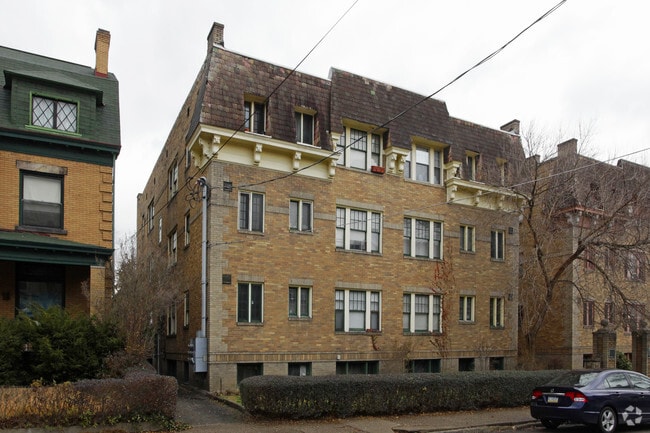
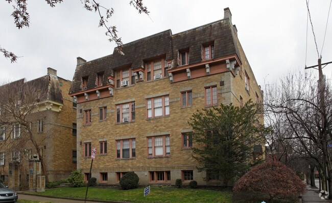
Property Record
6349 Walnut St, Pittsburgh, PA 15206

Property Detail
6349 Walnut St
Pittsburgh, PA
LOT 63 X 99.96 X 63.01 X 99.70
0084-M-00013-0000-00
Allegheny
Apartment
Pennsylvania
B and X Area of moderate flood hazard, usually the area between the limits of the 100-year and 500-year floods.
13
2024
0.14 AC
2025
Shadyside
070800
Pittsburgh
NEARBY LISTINGS FOR SALE OR LEASE
DEMOGRAPHICS near 6349 Walnut St
1 mile
3 mile
5 mile
2025 Total Population
32,587
180,533
341,099
2030 Population
32,373
180,289
341,022
Pop Growth 2025-2030
(0.66%)
(0.14%)
(0.02%)
Average Age
37
38
40
2025 Total Households
16,456
83,396
158,805
HH Growth 2025-2030
(0.91%)
(0.33%)
(0.12%)
Median Household Inc
$72,737
$61,898
$63,738
Avg Household Size
1.80
1.90
2.00
2025 Avg HH Vehicles
1.00
1.00
1.00
Median Home Value
$508,432
$298,107
$226,458
Median Year Built
1949
1948
1950
Nearby Places
Map Layers
Map Styles
 Street
 Aerial
Layers
 Traffic
 Biking
Places
Listings with unknown addresses are not visible on the map
- Restaurants
- Banks
- Shops
- Fitness
- Groceries
PUBLIC TRANSPORTATION
AIRPORT
Pittsburgh International
Drive
Walk
Distance
Pittsburgh International
36 min
21.9 mi
Arnold Palmer Regional
Drive
Walk
Distance
Arnold Palmer Regional
65 min
39.3 mi
Nearby Properties
Address
Land Use
TOTAL SIZE
Lot Size
Zoning
Address
Land Use
TOTAL SIZE
Lot Size
Zoning
Address
Land Use
TOTAL SIZE
Lot Size
Zoning
6.99 AC
Address
Land Use
TOTAL SIZE
Lot Size
Zoning
31.36 AC
Address
Land Use
TOTAL SIZE
Lot Size
Zoning
13.53 AC
Address
Land Use
TOTAL SIZE
Lot Size
Zoning
5.11 AC
Address
Land Use
TOTAL SIZE
Lot Size
Zoning
13.85 AC
Address
Land Use
TOTAL SIZE
Lot Size
Zoning
10.22 AC
Address
Land Use
TOTAL SIZE
Lot Size
Zoning
5.77 AC
Address
Land Use
TOTAL SIZE
Lot Size
Zoning
4.05 AC
Address
Land Use
TOTAL SIZE
Lot Size
Zoning
19.39 AC
Address
Land Use
TOTAL SIZE
Lot Size
Zoning
12.80 AC
Address
Land Use
TOTAL SIZE
Lot Size
Zoning
0.92 AC
Address
Land Use
TOTAL SIZE
Lot Size
Zoning
8.97 AC
Address
Land Use
TOTAL SIZE
Lot Size
Zoning
363.56 AC
Address
Land Use
TOTAL SIZE
Lot Size
Zoning
2.67 AC
Address
Land Use
TOTAL SIZE
Lot Size
Zoning
17.75 AC
Address
Land Use
TOTAL SIZE
Lot Size
Zoning
2.52 AC
Address
Land Use
TOTAL SIZE
Lot Size
Zoning
2.31 AC
Address
Land Use
TOTAL SIZE
Lot Size
Zoning
1.43 AC
Address
Land Use
TOTAL SIZE
Lot Size
Zoning
Address
Land Use
TOTAL SIZE
Lot Size
Zoning
7.89 AC
Address
Land Use
TOTAL SIZE
Lot Size
Zoning
160.63 AC
Address
Land Use
TOTAL SIZE
Lot Size
Zoning
4.10 AC
Address
Land Use
TOTAL SIZE
Lot Size
Zoning
1.36 AC
Address
Land Use
TOTAL SIZE
Lot Size
Zoning
1.19 AC
Address
Land Use
TOTAL SIZE
Lot Size
Zoning
5.90 AC
Address
Land Use
TOTAL SIZE
Lot Size
Zoning
1.22 AC
Address
Land Use
TOTAL SIZE
Lot Size
Zoning
1.54 AC
Address
Land Use
TOTAL SIZE
Lot Size
Zoning
3.13 AC
Address
Land Use
TOTAL SIZE
Lot Size
Zoning
1,950 SF
21.62 AC
The World's #1 Commercial Real Estate Marketplace
Connect with us
© 2026 CoStar Group
The information above has been obtained from sources believed reliable. While we do not doubt its accuracy we have not verified it and make no guarantee, warranty or representation about it. It is your responsibility to independently confirm its accuracy and completeness. Any projections, opinions, assumptions, or estimates used are for example only and do not represent the current or future performance of the property. The value of this transaction to you depends on tax and other factors which should be evaluated by your tax, financial, and legal advisors. You and your advisors should conduct a careful, independent investigation of the property to determine to your satisfaction the suitability of the property for your needs.