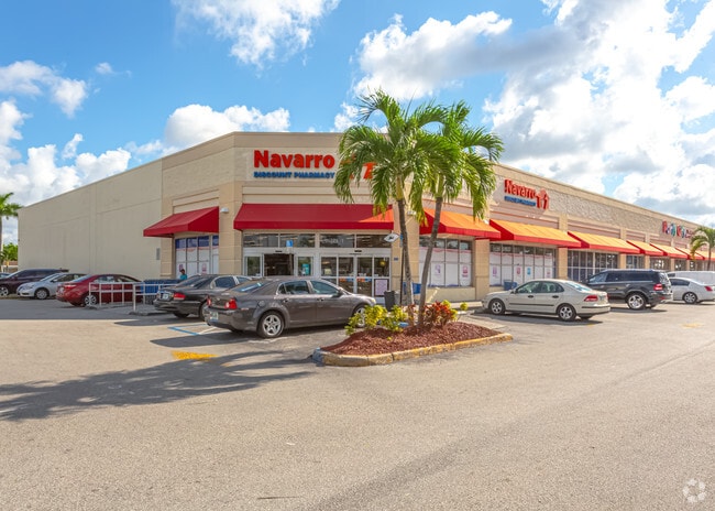
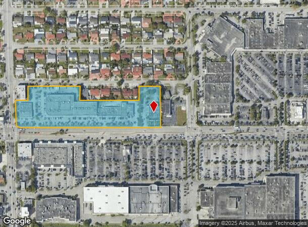
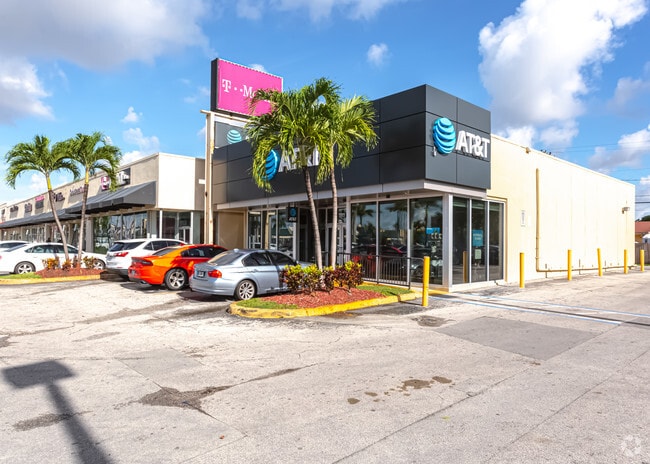
Property Record
635 W 49Th St, Hialeah, FL 33012
NEARBY LISTINGS FOR SALE OR LEASE
Property Detail
635 W 49Th St
Miami-Miami Beach-Kendall, FL
Component 4
04-3001-051-0050
COMPONENT 4 PB 142-90 T-18011 TR E & E57FT OF LOT 2 & W25FT OF LOT 3 BLK 106 PALM SPRINGS SUB SEC 3 5TH ADD PB 65-33 LOT SIZE 237761 SQ FT M/L FAU 04 3001 001 0100 0101 & 04 3001 013 1390
Regionalshoppingcenterormallwithanchorstore
Miami/Dade
X
Florida
12086C0281L
2,3
2024
5.46 AC
2025
Hialeah
000718
South Florida
76,791 SF
DEMOGRAPHICS near 635 W 49Th St
1 Mile
3 Mile
5 Mile
2024 Total Population
27,518
190,019
434,652
2029 Population
26,390
183,120
423,084
Pop Growth 2024-2029
(4.10%)
(3.63%)
(2.66%)
Average Age
45
45
42
2024 Total Households
8,805
63,000
143,804
HH Growth 2024-2029
(4.49%)
(4.08%)
(3.03%)
Median Household Inc
$50,275
$42,530
$50,038
Avg Household Size
3.00
2.90
2.90
2024 Avg HH Vehicles
2.00
2.00
2.00
Median Home Value
$350,768
$322,683
$328,055
Median Year Built
1966
1972
1976
Nearby Places
- Restaurants
- Banks
- Shops
- Fitness
- Groceries
PUBLIC TRANSPORTATION
COMMUTER RAIL
Okeechobee (Metrorail Green Line - Miami-Dade Transit (Metrorail/Metromover))
DRIVE
WALK
Distance
Okeechobee (Metrorail Green Line - Miami-Dade Transit (Metrorail/Metromover))
6 min
2.3 mi
Hialeah (Metrorail Green Line - Miami-Dade Transit (Metrorail/Metromover))
DRIVE
WALK
Distance
Hialeah (Metrorail Green Line - Miami-Dade Transit (Metrorail/Metromover))
6 min
3.0 mi
AIRPORT
Miami International
DRIVE
WALK
Distance
Miami International
18 min
7.9 mi
Fort Lauderdale/Hollywood International
DRIVE
WALK
Distance
Fort Lauderdale/Hollywood International
34 min
20.7 mi
Freight Ports
Port of Miami
DRIVE
WALK
Distance
Port of Miami
26 min
13.2 mi
SALE & LEASE HISTORY
LISTING DATE
SALE/LEASE

Sep 14, 2018
For Lease
Nearby Properties
Address
Land Use
TOTAL SIZE
Lot Size
Zoning
Address
Land Use
TOTAL SIZE
Lot Size
Zoning
1,837,228 SF
498.34 AC
8500
Address
Land Use
TOTAL SIZE
Lot Size
Zoning
614,708 SF
22.54 AC
4400
Address
Land Use
TOTAL SIZE
Lot Size
Zoning
7.62 AC
7200
Address
Land Use
TOTAL SIZE
Lot Size
Zoning
510,395 SF
28.32 AC
6500
Address
Land Use
TOTAL SIZE
Lot Size
Zoning
1,700 SF
7.24 AC
7100
Address
Land Use
TOTAL SIZE
Lot Size
Zoning
970,804 SF
46.92 AC
7100
Address
Land Use
TOTAL SIZE
Lot Size
Zoning
968,497 SF
58.61 AC
7100
Address
Land Use
TOTAL SIZE
Lot Size
Zoning
301,593 SF
16 AC
7100
Address
Land Use
TOTAL SIZE
Lot Size
Zoning
1,165,101 SF
115.84 AC
8000
Address
Land Use
TOTAL SIZE
Lot Size
Zoning
538,715 SF
24.72 AC
7100
Address
Land Use
TOTAL SIZE
Lot Size
Zoning
322,084 SF
6.60 AC
7100
Address
Land Use
TOTAL SIZE
Lot Size
Zoning
344,465 SF
5.03 AC
6400
Address
Land Use
TOTAL SIZE
Lot Size
Zoning
648,867 SF
33.08 AC
7100
Address
Land Use
TOTAL SIZE
Lot Size
Zoning
603,504 SF
27.15 AC
7100
Address
Land Use
TOTAL SIZE
Lot Size
Zoning
207,475 SF
51.47 AC
7100
Address
Land Use
TOTAL SIZE
Lot Size
Zoning
225,137 SF
80.89 AC
7600
Address
Land Use
TOTAL SIZE
Lot Size
Zoning
419,656 SF
8.61 AC
6400
Address
Land Use
TOTAL SIZE
Lot Size
Zoning
530,479 SF
10.13 AC
6400
Address
Land Use
TOTAL SIZE
Lot Size
Zoning
445,429 SF
4.45 AC
6400
Address
Land Use
TOTAL SIZE
Lot Size
Zoning
177,893 SF
15.02 AC
7100
Address
Land Use
TOTAL SIZE
Lot Size
Zoning
313,129 SF
16.06 AC
7100
Address
Land Use
TOTAL SIZE
Lot Size
Zoning
252,698 SF
13.22 AC
7100
Address
Land Use
TOTAL SIZE
Lot Size
Zoning
293,962 SF
9.99 AC
4400
Address
Land Use
TOTAL SIZE
Lot Size
Zoning
249,486 SF
11.84 AC
7100
Address
Land Use
TOTAL SIZE
Lot Size
Zoning
196,118 SF
11.06 AC
7100
Address
Land Use
TOTAL SIZE
Lot Size
Zoning
478,031 SF
1.72 AC
6600
Address
Land Use
TOTAL SIZE
Lot Size
Zoning
260,794 SF
12.50 AC
7100
Address
Land Use
TOTAL SIZE
Lot Size
Zoning
366,063 SF
57.35 AC
7100
Address
Land Use
TOTAL SIZE
Lot Size
Zoning
330,082 SF
7.02 AC
8000
Address
Land Use
TOTAL SIZE
Lot Size
Zoning
268,232 SF
14.33 AC
7100
The World's #1 Commercial Real Estate Marketplace
Connect with us
© 2025 CoStar Group
The information above has been obtained from sources believed reliable. While we do not doubt its accuracy we have not verified it and make no guarantee, warranty or representation about it. It is your responsibility to independently confirm its accuracy and completeness. Any projections, opinions, assumptions, or estimates used are for example only and do not represent the current or future performance of the property. The value of this transaction to you depends on tax and other factors which should be evaluated by your tax, financial, and legal advisors. You and your advisors should conduct a careful, independent investigation of the property to determine to your satisfaction the suitability of the property for your needs.