Property Record
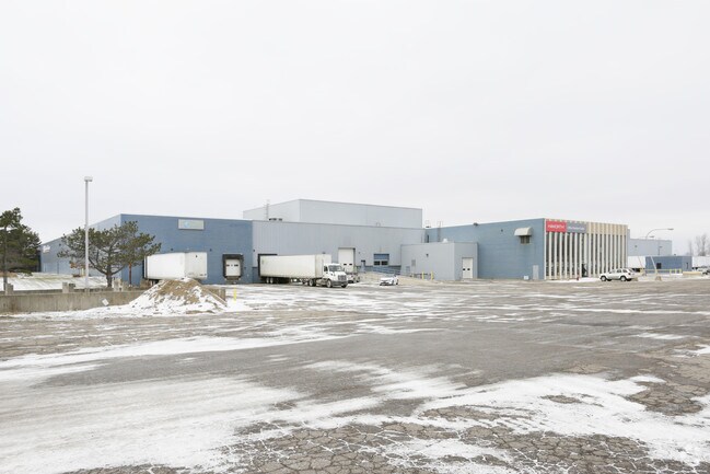
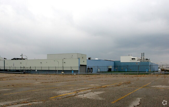
635 E 48Th St, Holland, MI 49423

Property Detail
635 E 48Th St
53-02-04-400-023
PT OF THE SE 1/4 BEING DESC AS: BEGINNING AT THE SE COR OF SD SEC, TH N 89 DEGREES 46' 24 W 1324.75 FT ALG S LI OF SD SEC; TH
Manufacturinglight
Allegan
I2
Michigan
B and X Area of moderate flood hazard, usually the area between the limits of the 100-year and 500-year floods.
36.66 AC
2025
NE Allegan/Holland
2026
West Michigan
032401
Holland, MI
397,258 SF
NEARBY LISTINGS FOR SALE OR LEASE
DEMOGRAPHICS near 635 E 48Th St
1 mile
3 mile
5 mile
2025 Total Population
1,138
34,009
74,505
2030 Population
1,159
34,428
75,727
Pop Growth 2025-2030
+ 1.85%
+ 1.23%
+ 1.64%
Average Age
40
39
40
2025 Total Households
454
12,533
28,223
HH Growth 2025-2030
+ 1.76%
+ 1.35%
+ 1.79%
Median Household Inc
$66,627
$70,068
$74,162
Avg Household Size
2.50
2.40
2.50
2025 Avg HH Vehicles
2.00
2.00
2.00
Median Home Value
$222,857
$257,627
$280,254
Median Year Built
1986
1971
1980
Nearby Places
Map Layers
Map Styles
 Street
 Aerial
Layers
 Traffic
 Biking
Places
Listings with unknown addresses are not visible on the map
- Restaurants
- Banks
- Shops
- Fitness
- Groceries
PUBLIC TRANSPORTATION
COMMUTER RAIL
Holland Amtrak Station (Pere Marquette - Amtrak)
Drive
Walk
Distance
Holland Amtrak Station (Pere Marquette - Amtrak)
8 min
3.6 mi
AIRPORT
Gerald R Ford International
Drive
Walk
Distance
Gerald R Ford International
45 min
35.4 mi
Freight Ports
Port Milwaukee
Drive
Walk
Distance
Port Milwaukee
276 min
235.3 mi
SALE & LEASE HISTORY
LISTING DATE
SALE/LEASE

Dec 07, 2020
For Lease
Nearby Properties
Address
Land Use
TOTAL SIZE
Lot Size
Zoning
Address
Land Use
TOTAL SIZE
Lot Size
Zoning
1,599,294 SF
Address
Land Use
TOTAL SIZE
Lot Size
Zoning
572,832 SF
10.89 AC
PUD
Address
Land Use
TOTAL SIZE
Lot Size
Zoning
1,788,352 SF
173.33 AC
Address
Land Use
TOTAL SIZE
Lot Size
Zoning
682,378 SF
99.60 AC
NA
Address
Land Use
TOTAL SIZE
Lot Size
Zoning
198,712 SF
Address
Land Use
TOTAL SIZE
Lot Size
Zoning
557,392 SF
28.50 AC
Address
Land Use
TOTAL SIZE
Lot Size
Zoning
556,819 SF
85.45 AC
Address
Land Use
TOTAL SIZE
Lot Size
Zoning
249,051 SF
24.77 AC
LDR
Address
Land Use
TOTAL SIZE
Lot Size
Zoning
660,002 SF
32.13 AC
I-2
Address
Land Use
TOTAL SIZE
Lot Size
Zoning
218,722 SF
8.59 AC
AGR
Address
Land Use
TOTAL SIZE
Lot Size
Zoning
674,052 SF
79.30 AC
Address
Land Use
TOTAL SIZE
Lot Size
Zoning
154,107 SF
Address
Land Use
TOTAL SIZE
Lot Size
Zoning
239,465 SF
Address
Land Use
TOTAL SIZE
Lot Size
Zoning
132,127 SF
42.69 AC
SEE MAP
Address
Land Use
TOTAL SIZE
Lot Size
Zoning
589,649 SF
92.65 AC
Address
Land Use
TOTAL SIZE
Lot Size
Zoning
94,790 SF
1.74 AC
C-2
Address
Land Use
TOTAL SIZE
Lot Size
Zoning
150,822 SF
Address
Land Use
TOTAL SIZE
Lot Size
Zoning
114,088 SF
10.79 AC
PRD
Address
Land Use
TOTAL SIZE
Lot Size
Zoning
118,444 SF
4.39 AC
Address
Land Use
TOTAL SIZE
Lot Size
Zoning
181,754 SF
13.44 AC
R3
Address
Land Use
TOTAL SIZE
Lot Size
Zoning
391,842 SF
28.34 AC
Address
Land Use
TOTAL SIZE
Lot Size
Zoning
357,000 SF
23.35 AC
Address
Land Use
TOTAL SIZE
Lot Size
Zoning
228,876 SF
49.31 AC
GMU
Address
Land Use
TOTAL SIZE
Lot Size
Zoning
73,700 SF
Address
Land Use
TOTAL SIZE
Lot Size
Zoning
372,017 SF
17.60 AC
R-2
Address
Land Use
TOTAL SIZE
Lot Size
Zoning
158,661 SF
17.28 AC
Address
Land Use
TOTAL SIZE
Lot Size
Zoning
146,357 SF
20.04 AC
Address
Land Use
TOTAL SIZE
Lot Size
Zoning
73,663 SF
4.66 AC
Address
Land Use
TOTAL SIZE
Lot Size
Zoning
252,065 SF
13.98 AC
The World's #1 Commercial Real Estate Marketplace
Connect with us
© 2026 CoStar Group
The information above has been obtained from sources believed reliable. While we do not doubt its accuracy we have not verified it and make no guarantee, warranty or representation about it. It is your responsibility to independently confirm its accuracy and completeness. Any projections, opinions, assumptions, or estimates used are for example only and do not represent the current or future performance of the property. The value of this transaction to you depends on tax and other factors which should be evaluated by your tax, financial, and legal advisors. You and your advisors should conduct a careful, independent investigation of the property to determine to your satisfaction the suitability of the property for your needs.