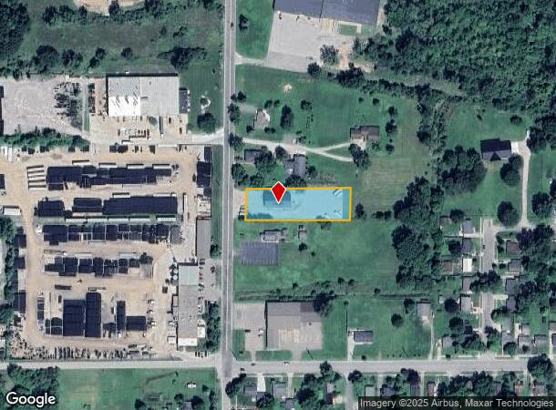
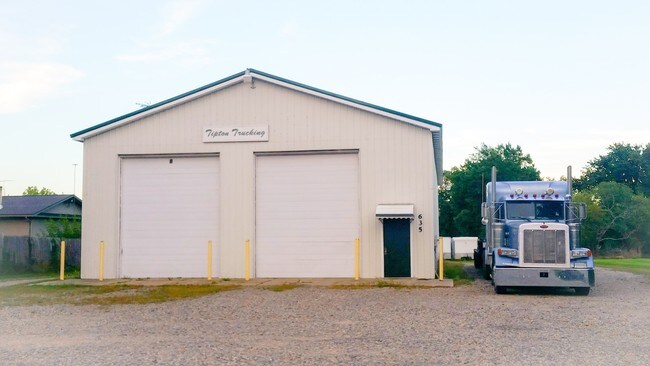
Property Record
635 S Chestnut St, Owosso, MI 48867

NEARBY LISTINGS FOR SALE OR LEASE
-
-
View all Owosso listings for sale on LoopNet.com
Property Detail
635 S Chestnut St
050-546-000-021-00
COM N & S 14 LN SEC 23 T7N R2E AT A PT 463.68' N OF CEN OF SD SEC TH N 100' TH ELY PAR WITH THE E & W 14 LN OF SD SEC 361.68'
Commercialnec
Shiawassee
X
Michigan
26155C0227C
0.76 AC
2024
Other Market Areas
2025
Owosso, MI
030700
DEMOGRAPHICS near 635 S Chestnut St
1 Mile
3 Mile
5 Mile
2024 Total Population
5,399
21,025
28,161
2029 Population
5,411
21,043
28,141
Pop Growth 2024-2029
+ 0.22%
+ 0.09%
(0.07%)
Average Age
40
41
42
2024 Total Households
2,303
8,966
11,953
HH Growth 2024-2029
+ 0.17%
+ 0.06%
(0.10%)
Median Household Inc
$44,112
$44,484
$45,869
Avg Household Size
2.30
2.30
2.30
2024 Avg HH Vehicles
2.00
2.00
2.00
Median Home Value
$77,074
$113,420
$130,184
Median Year Built
1955
1957
1961
Nearby Places
Map Layers
Map Styles
 Street
 Aerial
- Restaurants
- Banks
- Shops
- Fitness
- Groceries
PUBLIC TRANSPORTATION
AIRPORT
Bishop International
DRIVE
WALK
Distance
Bishop International
48 min
28.4 mi
Capital Region International
DRIVE
WALK
Distance
Capital Region International
53 min
37.2 mi
Freight Ports
Port of Toledo
DRIVE
WALK
Distance
Port of Toledo
164 min
128.1 mi
SALE & LEASE HISTORY
LISTING DATE
SALE/LEASE

Oct 10, 2016
For Sale
Nearby Properties
Address
Land Use
TOTAL SIZE
Lot Size
Zoning
Address
Land Use
TOTAL SIZE
Lot Size
Zoning
207,259 SF
24.89 AC
Address
Land Use
TOTAL SIZE
Lot Size
Zoning
20.30 AC
Address
Land Use
TOTAL SIZE
Lot Size
Zoning
32.95 AC
Address
Land Use
TOTAL SIZE
Lot Size
Zoning
11.10 AC
Address
Land Use
TOTAL SIZE
Lot Size
Zoning
10,100 SF
17.75 AC
Address
Land Use
TOTAL SIZE
Lot Size
Zoning
10.25 AC
Address
Land Use
TOTAL SIZE
Lot Size
Zoning
11.90 AC
Address
Land Use
TOTAL SIZE
Lot Size
Zoning
16,202 SF
5.15 AC
Address
Land Use
TOTAL SIZE
Lot Size
Zoning
1.72 AC
Address
Land Use
TOTAL SIZE
Lot Size
Zoning
17.17 AC
Address
Land Use
TOTAL SIZE
Lot Size
Zoning
Address
Land Use
TOTAL SIZE
Lot Size
Zoning
56,456 SF
6.50 AC
Address
Land Use
TOTAL SIZE
Lot Size
Zoning
54 AC
Address
Land Use
TOTAL SIZE
Lot Size
Zoning
0.64 AC
Address
Land Use
TOTAL SIZE
Lot Size
Zoning
11.05 AC
Address
Land Use
TOTAL SIZE
Lot Size
Zoning
15.80 AC
Address
Land Use
TOTAL SIZE
Lot Size
Zoning
18.83 AC
Address
Land Use
TOTAL SIZE
Lot Size
Zoning
23.09 AC
Address
Land Use
TOTAL SIZE
Lot Size
Zoning
180.26 AC
Address
Land Use
TOTAL SIZE
Lot Size
Zoning
11,014 SF
2.61 AC
Address
Land Use
TOTAL SIZE
Lot Size
Zoning
4.16 AC
Address
Land Use
TOTAL SIZE
Lot Size
Zoning
2.52 AC
Address
Land Use
TOTAL SIZE
Lot Size
Zoning
0.39 AC
Address
Land Use
TOTAL SIZE
Lot Size
Zoning
212,405 SF
29 AC
Address
Land Use
TOTAL SIZE
Lot Size
Zoning
4.88 AC
Address
Land Use
TOTAL SIZE
Lot Size
Zoning
10.56 AC
Address
Land Use
TOTAL SIZE
Lot Size
Zoning
37.80 AC
Address
Land Use
TOTAL SIZE
Lot Size
Zoning
24,116 SF
3.70 AC
Address
Land Use
TOTAL SIZE
Lot Size
Zoning
8.70 AC
Address
Land Use
TOTAL SIZE
Lot Size
Zoning
6.81 AC
The World's #1 Commercial Real Estate Marketplace
Connect with us
© 2025 CoStar Group
The information above has been obtained from sources believed reliable. While we do not doubt its accuracy we have not verified it and make no guarantee, warranty or representation about it. It is your responsibility to independently confirm its accuracy and completeness. Any projections, opinions, assumptions, or estimates used are for example only and do not represent the current or future performance of the property. The value of this transaction to you depends on tax and other factors which should be evaluated by your tax, financial, and legal advisors. You and your advisors should conduct a careful, independent investigation of the property to determine to your satisfaction the suitability of the property for your needs.