Property Record
635 State Highway 46 E, Boerne, TX 78006

Property Detail
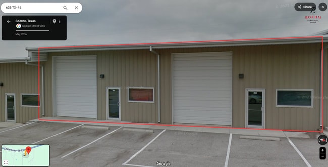
635 State Highway 46 E
287384
A10163 - SURVEY 824 EPI CO 5.796 ACRES
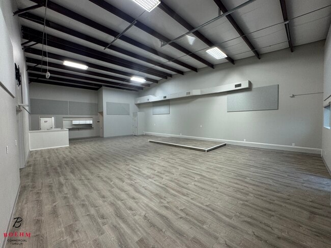
Commercialbuilding
Kendall
B and X Area of moderate flood hazard, usually the area between the limits of the 100-year and 500-year floods.
Texas
2024
5.80 AC
2025
Kendall County
970406
San Antonio
47,590 SF
San Antonio-New Braunfels, TX
NEARBY LISTINGS FOR SALE OR LEASE
-
-
View all Boerne listings for lease on LoopNet.com
DEMOGRAPHICS near 635 State Highway 46 E
1 mile
3 mile
5 mile
2025 Total Population
515
3,798
11,279
2030 Population
580
4,279
12,789
Pop Growth 2025-2030
+ 12.62%
+ 12.66%
+ 13.39%
Average Age
48
46
45
2025 Total Households
194
1,369
4,068
HH Growth 2025-2030
+ 12.89%
+ 12.78%
+ 13.50%
Median Household Inc
$207,921
$181,626
$165,794
Avg Household Size
2.70
2.70
2.80
2025 Avg HH Vehicles
3.00
3.00
3.00
Median Home Value
$960,713
$849,340
$783,691
Median Year Built
2005
2006
2006
Nearby Places
Map Layers
Map Styles
 Street
 Aerial
Transit
 Traffic
 Biking
Places
Listings with unknown addresses are not visible on the map
- Restaurants
- Banks
- Shops
- Fitness
- Groceries
PUBLIC TRANSPORTATION
AIRPORT
San Antonio International
Drive
Walk
Distance
San Antonio International
42 min
33.0 mi
SALE & LEASE HISTORY
LISTING DATE
SALE/LEASE

Feb 06, 2025
For Lease
Nearby Properties
Address
Land Use
TOTAL SIZE
Lot Size
Zoning
Address
Land Use
TOTAL SIZE
Lot Size
Zoning
157,537 SF
83.94 AC
Address
Land Use
TOTAL SIZE
Lot Size
Zoning
166,650 SF
14.62 AC
Address
Land Use
TOTAL SIZE
Lot Size
Zoning
43,173 SF
91.99 AC
Address
Land Use
TOTAL SIZE
Lot Size
Zoning
46,506 SF
11.40 AC
Address
Land Use
TOTAL SIZE
Lot Size
Zoning
10,800 SF
13.12 AC
Address
Land Use
TOTAL SIZE
Lot Size
Zoning
47,002 SF
6.01 AC
Address
Land Use
TOTAL SIZE
Lot Size
Zoning
16,700 SF
1.71 AC
Address
Land Use
TOTAL SIZE
Lot Size
Zoning
13,041 SF
10.44 AC
Address
Land Use
TOTAL SIZE
Lot Size
Zoning
8,932 SF
1.15 AC
Address
Land Use
TOTAL SIZE
Lot Size
Zoning
18,338 SF
4.50 AC
Address
Land Use
TOTAL SIZE
Lot Size
Zoning
7,050 SF
1.01 AC
Address
Land Use
TOTAL SIZE
Lot Size
Zoning
10,500 SF
1.23 AC
Address
Land Use
TOTAL SIZE
Lot Size
Zoning
11,460 SF
3.01 AC
Address
Land Use
TOTAL SIZE
Lot Size
Zoning
32.21 AC
Address
Land Use
TOTAL SIZE
Lot Size
Zoning
8,952 SF
6.49 AC
Address
Land Use
TOTAL SIZE
Lot Size
Zoning
13,864 SF
4.81 AC
Address
Land Use
TOTAL SIZE
Lot Size
Zoning
31,504 SF
2.10 AC
Address
Land Use
TOTAL SIZE
Lot Size
Zoning
28,705 SF
1.51 AC
Address
Land Use
TOTAL SIZE
Lot Size
Zoning
13,857 SF
2.49 AC
Address
Land Use
TOTAL SIZE
Lot Size
Zoning
8,002 SF
4.63 AC
Address
Land Use
TOTAL SIZE
Lot Size
Zoning
12,128 SF
3.88 AC
Address
Land Use
TOTAL SIZE
Lot Size
Zoning
6,000 SF
3 AC
Address
Land Use
TOTAL SIZE
Lot Size
Zoning
9,076 SF
2.94 AC
Address
Land Use
TOTAL SIZE
Lot Size
Zoning
5,508 SF
1.53 AC
Address
Land Use
TOTAL SIZE
Lot Size
Zoning
7,165 SF
23.34 AC
Address
Land Use
TOTAL SIZE
Lot Size
Zoning
1.67 AC
Address
Land Use
TOTAL SIZE
Lot Size
Zoning
5,448 SF
0.39 AC
Address
Land Use
TOTAL SIZE
Lot Size
Zoning
Address
Land Use
TOTAL SIZE
Lot Size
Zoning
7,490 SF
1.03 AC
The World's #1 Commercial Real Estate Marketplace
Connect with us
© 2026 CoStar Group
The information above has been obtained from sources believed reliable. While we do not doubt its accuracy we have not verified it and make no guarantee, warranty or representation about it. It is your responsibility to independently confirm its accuracy and completeness. Any projections, opinions, assumptions, or estimates used are for example only and do not represent the current or future performance of the property. The value of this transaction to you depends on tax and other factors which should be evaluated by your tax, financial, and legal advisors. You and your advisors should conduct a careful, independent investigation of the property to determine to your satisfaction the suitability of the property for your needs.