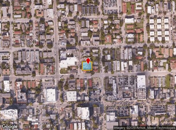
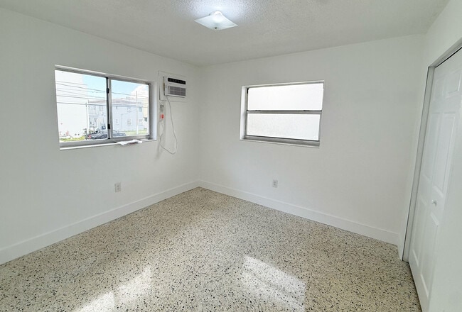
Property Record
635 Sw 7Th Ct, Miami, FL 33130
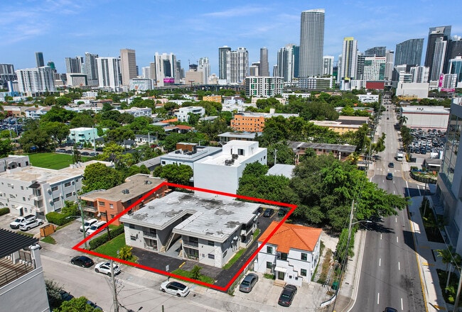
This Property Is For Sale
NEARBY LISTINGS FOR SALE OR LEASE
Property Detail
635 Sw 7Th Ct
Miami-Miami Beach-Kendall, FL
Druid Court 1St Add
01-4138-050-0180
DRUID COURT 1ST ADD PB 6-168 LOTS 4 & 5 BLK C LOT SIZE 12500 SQUARE FEET OR 11634-861 1282 1
Multifamilydwelling
Miami/Dade
X
Florida
12086C0314L
4,5
2024
0.29 AC
2025
Little Havana
006606
South Florida
7,888 SF
DEMOGRAPHICS near 635 Sw 7Th Ct
1 Mile
3 Mile
5 Mile
2024 Total Population
73,298
286,288
516,442
2029 Population
72,609
283,866
512,926
Pop Growth 2024-2029
(0.94%)
(0.85%)
(0.68%)
Average Age
39
41
41
2024 Total Households
33,637
126,305
224,200
HH Growth 2024-2029
(1.43%)
(0.85%)
(0.62%)
Median Household Inc
$50,713
$55,078
$54,728
Avg Household Size
2.10
2.10
2.20
2024 Avg HH Vehicles
1.00
1.00
1.00
Median Home Value
$436,393
$459,836
$463,980
Median Year Built
2000
1990
1978
Nearby Places
Map Layers
Map Styles
 Street
 Aerial
- Restaurants
- Banks
- Shops
- Fitness
- Groceries
PUBLIC TRANSPORTATION
TRANSIT/SUBWAY
Eighth Street (Metromover Brickell Loop - Miami-Dade Transit (Metrorail/Metromover))
DRIVE
WALK
Distance
Eighth Street (Metromover Brickell Loop - Miami-Dade Transit (Metrorail/Metromover))
3 min
18 min
1.0 mi
Fifth Street (Metromover Brickell Loop - Miami-Dade Transit (Metrorail/Metromover))
DRIVE
WALK
Distance
Fifth Street (Metromover Brickell Loop - Miami-Dade Transit (Metrorail/Metromover))
4 min
19 min
1.0 mi
Brickell (Metromover) (Metromover Brickell Loop - Miami-Dade Transit (Metrorail/Metromover))
DRIVE
WALK
Distance
Brickell (Metromover) (Metromover Brickell Loop - Miami-Dade Transit (Metrorail/Metromover))
3 min
19 min
1.0 mi
COMMUTER RAIL
Brickell (Metrorail) (Metrorail Green Line - Miami-Dade Transit (Metrorail/Metromover))
DRIVE
WALK
Distance
Brickell (Metrorail) (Metrorail Green Line - Miami-Dade Transit (Metrorail/Metromover))
3 min
18 min
0.9 mi
Government Center (Metromover Brickell Loop - Miami-Dade Transit (Metrorail/Metromover), Metromover Downtown Loop - Miami-Dade Transit (Metrorail/Metromover), Metromover Omni Loop - Miami-Dade Transit (Metrorail/Metromover), Metrorail Green Line - Miami-Dade Transit (Metrorail/Metromover))
DRIVE
WALK
Distance
Government Center (Metromover Brickell Loop - Miami-Dade Transit (Metrorail/Metromover), Metromover Downtown Loop - Miami-Dade Transit (Metrorail/Metromover), Metromover Omni Loop - Miami-Dade Transit (Metrorail/Metromover), Metrorail Green Line - Miami-Dade Transit (Metrorail/Metromover))
4 min
1.4 mi
AIRPORT
Miami International
DRIVE
WALK
Distance
Miami International
22 min
11.1 mi
Fort Lauderdale/Hollywood International
DRIVE
WALK
Distance
Fort Lauderdale/Hollywood International
35 min
24.3 mi
Freight Ports
Port of Miami
DRIVE
WALK
Distance
Port of Miami
10 min
3.7 mi
Nearby Properties
Address
Land Use
TOTAL SIZE
Lot Size
Zoning
Address
Land Use
TOTAL SIZE
Lot Size
Zoning
1,050,691 SF
0.83 AC
6408
Address
Land Use
TOTAL SIZE
Lot Size
Zoning
4,758,614 SF
810.91 AC
8000
Address
Land Use
TOTAL SIZE
Lot Size
Zoning
955,966 SF
38.91 AC
9600
Address
Land Use
TOTAL SIZE
Lot Size
Zoning
2,559,318 SF
2.21 AC
6407
Address
Land Use
TOTAL SIZE
Lot Size
Zoning
2,039,308 SF
2.46 AC
6401
Address
Land Use
TOTAL SIZE
Lot Size
Zoning
928,000 SF
14.30 AC
8000
Address
Land Use
TOTAL SIZE
Lot Size
Zoning
1,110,657 SF
3.83 AC
6407
Address
Land Use
TOTAL SIZE
Lot Size
Zoning
16.13 AC
6100
Address
Land Use
TOTAL SIZE
Lot Size
Zoning
1,346,294 SF
1.89 AC
6408
Address
Land Use
TOTAL SIZE
Lot Size
Zoning
2,403,353 SF
7.37 AC
6100
Address
Land Use
TOTAL SIZE
Lot Size
Zoning
1,938,271 SF
6.62 AC
6402
Address
Land Use
TOTAL SIZE
Lot Size
Zoning
1,162,113 SF
1.92 AC
6407
Address
Land Use
TOTAL SIZE
Lot Size
Zoning
1,075,124 SF
1.61 AC
6405
Address
Land Use
TOTAL SIZE
Lot Size
Zoning
1,544,491 SF
0.97 AC
6401
Address
Land Use
TOTAL SIZE
Lot Size
Zoning
782,686 SF
0.06 AC
6401
Address
Land Use
TOTAL SIZE
Lot Size
Zoning
1,657,362 SF
1.15 AC
6401
Address
Land Use
TOTAL SIZE
Lot Size
Zoning
1,072,012 SF
1.78 AC
6407
Address
Land Use
TOTAL SIZE
Lot Size
Zoning
244,533 SF
3.53 AC
6600
Address
Land Use
TOTAL SIZE
Lot Size
Zoning
694,863 SF
1.90 AC
6407
Address
Land Use
TOTAL SIZE
Lot Size
Zoning
656,821 SF
2.06 AC
6407
Address
Land Use
TOTAL SIZE
Lot Size
Zoning
303,989 SF
1.47 AC
6600
Address
Land Use
TOTAL SIZE
Lot Size
Zoning
416,675 SF
6.48 AC
6401
Address
Land Use
TOTAL SIZE
Lot Size
Zoning
1,004,006 SF
0.92 AC
6401
Address
Land Use
TOTAL SIZE
Lot Size
Zoning
2.50 AC
6407
Address
Land Use
TOTAL SIZE
Lot Size
Zoning
585,775 SF
1.86 AC
6101
Address
Land Use
TOTAL SIZE
Lot Size
Zoning
868,860 SF
2.14 AC
6402
Address
Land Use
TOTAL SIZE
Lot Size
Zoning
491,308 SF
0.14 AC
6401
Address
Land Use
TOTAL SIZE
Lot Size
Zoning
903,993 SF
0.60 AC
6412
Address
Land Use
TOTAL SIZE
Lot Size
Zoning
872,245 SF
0.56 AC
6401
Address
Land Use
TOTAL SIZE
Lot Size
Zoning
727,757 SF
0.64 AC
6408
The World's #1 Commercial Real Estate Marketplace
Connect with us
© 2025 CoStar Group
The information above has been obtained from sources believed reliable. While we do not doubt its accuracy we have not verified it and make no guarantee, warranty or representation about it. It is your responsibility to independently confirm its accuracy and completeness. Any projections, opinions, assumptions, or estimates used are for example only and do not represent the current or future performance of the property. The value of this transaction to you depends on tax and other factors which should be evaluated by your tax, financial, and legal advisors. You and your advisors should conduct a careful, independent investigation of the property to determine to your satisfaction the suitability of the property for your needs.