Property Record
635 Us Highway 45 N, Henderson, TN 38340

NEARBY LISTINGS FOR SALE OR LEASE
-
-
View all Henderson listings for sale on LoopNet.com
Property Detail
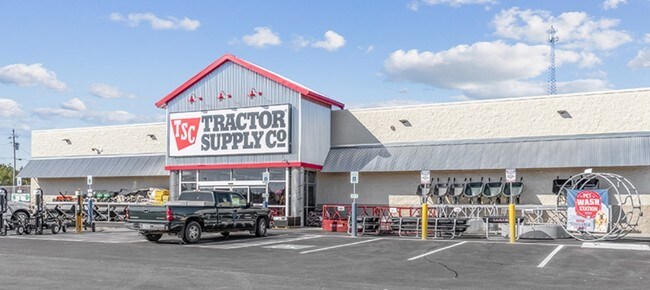
635 Us Highway 45 N
012033 04406
DISTRICT: 06, COUNTY AREA: H50
Departmentstore
Chester
X
Tennessee
47113C0435E
3.03 AC
2025
Tennessee West Area
2025
Other Market Areas
970200
Jackson, TN
18,798 SF
DEMOGRAPHICS near 635 Us Highway 45 N
1 Mile
3 Mile
5 Mile
2024 Total Population
2,630
7,706
10,879
2029 Population
2,724
8,008
11,276
Pop Growth 2024-2029
+ 3.57%
+ 3.92%
+ 3.65%
Average Age
34
37
38
2024 Total Households
751
2,638
3,895
HH Growth 2024-2029
+ 3.60%
+ 4.09%
+ 3.72%
Median Household Inc
$48,776
$50,257
$52,631
Avg Household Size
2.40
2.50
2.50
2024 Avg HH Vehicles
2.00
2.00
2.00
Median Home Value
$124,865
$129,795
$142,674
Median Year Built
1978
1983
1985
Nearby Places
Map Layers
Map Styles
 Street
 Aerial
- Restaurants
- Banks
- Shops
- Fitness
- Groceries
SALE & LEASE HISTORY
LISTING DATE
SALE/LEASE

Nov 06, 2019
For Sale
Nearby Properties
Address
Land Use
TOTAL SIZE
Lot Size
Zoning
Address
Land Use
TOTAL SIZE
Lot Size
Zoning
78,963 SF
36.19 AC
Address
Land Use
TOTAL SIZE
Lot Size
Zoning
63,647 SF
27.23 AC
Address
Land Use
TOTAL SIZE
Lot Size
Zoning
93,036 SF
12.50 AC
Address
Land Use
TOTAL SIZE
Lot Size
Zoning
54,740 SF
1.73 AC
Address
Land Use
TOTAL SIZE
Lot Size
Zoning
39,480 SF
13 AC
Address
Land Use
TOTAL SIZE
Lot Size
Zoning
39,280 SF
13 AC
Address
Land Use
TOTAL SIZE
Lot Size
Zoning
51,300 SF
6.45 AC
M1
Address
Land Use
TOTAL SIZE
Lot Size
Zoning
137,200 SF
20 AC
Address
Land Use
TOTAL SIZE
Lot Size
Zoning
24,957 SF
10 AC
Address
Land Use
TOTAL SIZE
Lot Size
Zoning
12,475 SF
6.45 AC
Address
Land Use
TOTAL SIZE
Lot Size
Zoning
7,885 SF
3 AC
Address
Land Use
TOTAL SIZE
Lot Size
Zoning
6,343 SF
5.26 AC
Address
Land Use
TOTAL SIZE
Lot Size
Zoning
7,785 SF
5.70 AC
Address
Land Use
TOTAL SIZE
Lot Size
Zoning
9,715 SF
1.74 AC
Address
Land Use
TOTAL SIZE
Lot Size
Zoning
153,600 SF
10 AC
M2
Address
Land Use
TOTAL SIZE
Lot Size
Zoning
13,356 SF
0.29 AC
B2
Address
Land Use
TOTAL SIZE
Lot Size
Zoning
8,294 SF
3.40 AC
B4
Address
Land Use
TOTAL SIZE
Lot Size
Zoning
1,230 SF
8 AC
Address
Land Use
TOTAL SIZE
Lot Size
Zoning
4,499 SF
3.10 AC
B4
Address
Land Use
TOTAL SIZE
Lot Size
Zoning
88,672 SF
10.20 AC
B4
Address
Land Use
TOTAL SIZE
Lot Size
Zoning
16,612 SF
2.73 AC
RCT
Address
Land Use
TOTAL SIZE
Lot Size
Zoning
9,228 SF
1.20 AC
I
Address
Land Use
TOTAL SIZE
Lot Size
Zoning
6,496 SF
2.41 AC
B4
Address
Land Use
TOTAL SIZE
Lot Size
Zoning
37,112 SF
5.61 AC
M1
Address
Land Use
TOTAL SIZE
Lot Size
Zoning
26,005 SF
2.62 AC
B1
Address
Land Use
TOTAL SIZE
Lot Size
Zoning
28,088 SF
4.30 AC
B4
Address
Land Use
TOTAL SIZE
Lot Size
Zoning
4,714 SF
2.08 AC
Address
Land Use
TOTAL SIZE
Lot Size
Zoning
6,257 SF
8.52 AC
Address
Land Use
TOTAL SIZE
Lot Size
Zoning
9,770 SF
4.25 AC
B4
The World's #1 Commercial Real Estate Marketplace
Connect with us
© 2026 CoStar Group
The information above has been obtained from sources believed reliable. While we do not doubt its accuracy we have not verified it and make no guarantee, warranty or representation about it. It is your responsibility to independently confirm its accuracy and completeness. Any projections, opinions, assumptions, or estimates used are for example only and do not represent the current or future performance of the property. The value of this transaction to you depends on tax and other factors which should be evaluated by your tax, financial, and legal advisors. You and your advisors should conduct a careful, independent investigation of the property to determine to your satisfaction the suitability of the property for your needs.