Property Record
635 W Hermitage Rd Ne, Rome, GA 30161


NEARBY LISTINGS FOR SALE OR LEASE
Property Detail
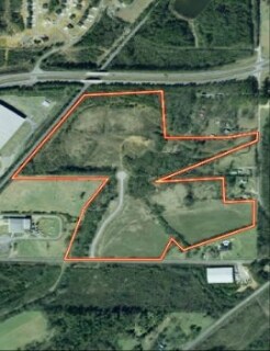
635 W Hermitage Rd Ne
Rome, GA
Board Commissioners
L11W-109
PB31-36 LL 54 23/3 LANDLOT: 54 LANDDIST: 23
Governmentalpublicusegeneral
Floyd
X
Georgia
13015C0125H
53.53 AC
0
Georgia Northwest
2024
Other Market Areas
000900
DEMOGRAPHICS near 635 W Hermitage Rd Ne
1 Mile
3 Mile
5 Mile
2024 Total Population
1,245
4,220
14,848
2029 Population
1,242
4,250
15,112
Pop Growth 2024-2029
(0.24%)
+ 0.71%
+ 1.78%
Average Age
41
41
41
2024 Total Households
523
1,689
5,778
HH Growth 2024-2029
(0.19%)
+ 0.47%
+ 1.63%
Median Household Inc
$65,902
$63,074
$66,313
Avg Household Size
2.30
2.40
2.50
2024 Avg HH Vehicles
2.00
2.00
2.00
Median Home Value
$189,230
$175,562
$168,927
Median Year Built
1966
1977
1980
Nearby Places
Map Layers
Map Styles
 Street
 Aerial
- Restaurants
- Banks
- Shops
- Fitness
- Groceries
Nearby Properties
Address
Land Use
TOTAL SIZE
Lot Size
Zoning
Address
Land Use
TOTAL SIZE
Lot Size
Zoning
180,000 SF
76.07 AC
H-I
Address
Land Use
TOTAL SIZE
Lot Size
Zoning
258,750 SF
Address
Land Use
TOTAL SIZE
Lot Size
Zoning
441,457 SF
34.16 AC
H-I
Address
Land Use
TOTAL SIZE
Lot Size
Zoning
566,100 SF
35.05 AC
Address
Land Use
TOTAL SIZE
Lot Size
Zoning
332,825 SF
36.34 AC
H-I
Address
Land Use
TOTAL SIZE
Lot Size
Zoning
344,677 SF
27.65 AC
H-I
Address
Land Use
TOTAL SIZE
Lot Size
Zoning
102,828 SF
26.04 AC
H-I
Address
Land Use
TOTAL SIZE
Lot Size
Zoning
25,855 SF
13 AC
Address
Land Use
TOTAL SIZE
Lot Size
Zoning
48 AC
O-I
Address
Land Use
TOTAL SIZE
Lot Size
Zoning
718.90 AC
A-R
Address
Land Use
TOTAL SIZE
Lot Size
Zoning
44,500 SF
37.10 AC
H-I
Address
Land Use
TOTAL SIZE
Lot Size
Zoning
509.12 AC
A-R
Address
Land Use
TOTAL SIZE
Lot Size
Zoning
19,200 SF
0.45 AC
Address
Land Use
TOTAL SIZE
Lot Size
Zoning
536 AC
A-R
Address
Land Use
TOTAL SIZE
Lot Size
Zoning
18,000 SF
23.71 AC
H-I
Address
Land Use
TOTAL SIZE
Lot Size
Zoning
1,250 SF
4.68 AC
L-I
Address
Land Use
TOTAL SIZE
Lot Size
Zoning
1,400 SF
273.90 AC
A-R
Address
Land Use
TOTAL SIZE
Lot Size
Zoning
52,716 SF
0.60 AC
C-B-C
Address
Land Use
TOTAL SIZE
Lot Size
Zoning
89,928 SF
17.27 AC
L-I
Address
Land Use
TOTAL SIZE
Lot Size
Zoning
13,500 SF
3.03 AC
H-C
Address
Land Use
TOTAL SIZE
Lot Size
Zoning
57.31 AC
Address
Land Use
TOTAL SIZE
Lot Size
Zoning
4,930 SF
3 AC
H-C
Address
Land Use
TOTAL SIZE
Lot Size
Zoning
3,190 SF
3 AC
C-C
Address
Land Use
TOTAL SIZE
Lot Size
Zoning
14,736 SF
0.81 AC
C-C
Address
Land Use
TOTAL SIZE
Lot Size
Zoning
26,000 SF
7.20 AC
H-I
Address
Land Use
TOTAL SIZE
Lot Size
Zoning
60,480 SF
10.40 AC
H-I
Address
Land Use
TOTAL SIZE
Lot Size
Zoning
28,250 SF
8.95 AC
L-I
Address
Land Use
TOTAL SIZE
Lot Size
Zoning
120.57 AC
S-R
Address
Land Use
TOTAL SIZE
Lot Size
Zoning
41.73 AC
H-I
The World's #1 Commercial Real Estate Marketplace
Connect with us
© 2026 CoStar Group
The information above has been obtained from sources believed reliable. While we do not doubt its accuracy we have not verified it and make no guarantee, warranty or representation about it. It is your responsibility to independently confirm its accuracy and completeness. Any projections, opinions, assumptions, or estimates used are for example only and do not represent the current or future performance of the property. The value of this transaction to you depends on tax and other factors which should be evaluated by your tax, financial, and legal advisors. You and your advisors should conduct a careful, independent investigation of the property to determine to your satisfaction the suitability of the property for your needs.