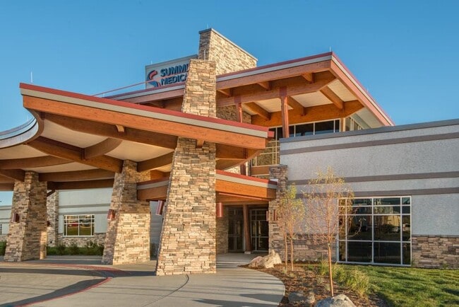
Property Record
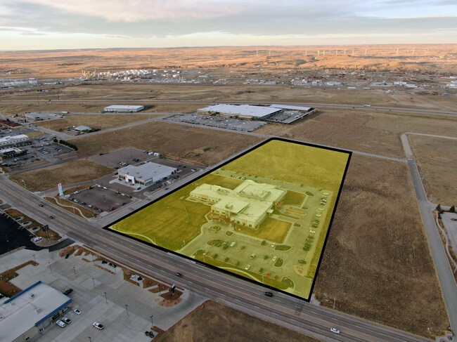
6350 E 2Nd St, Casper, WY 82609


Property Detail
6350 E 2Nd St
Casper, WY
MC MURRY BUS PK #6 LOT 1
33-78-08-1-0-400100
Natrona
Hospitalprivate
Wyoming
B and X Area of moderate flood hazard, usually the area between the limits of the 100-year and 500-year floods.
1
2024
8 AC
2025
I-25 Corridor/Casper
001801
Other Market Areas
50,537 SF
NEARBY LISTINGS FOR SALE OR LEASE
DEMOGRAPHICS near 6350 E 2Nd St
1 mile
3 mile
5 mile
2025 Total Population
802
16,546
37,303
2030 Population
830
16,731
37,745
Pop Growth 2025-2030
+ 3.49%
+ 1.12%
+ 1.18%
Average Age
41
40
40
2025 Total Households
340
6,568
15,964
HH Growth 2025-2030
+ 3.53%
+ 1.16%
+ 1.25%
Median Household Inc
$87,179
$86,303
$69,055
Avg Household Size
2.40
2.50
2.30
2025 Avg HH Vehicles
2.00
2.00
2.00
Median Home Value
$565,909
$303,474
$262,230
Median Year Built
2000
1985
1975
Nearby Places
Map Layers
Map Styles
 Street
 Aerial
Layers
 Traffic
 Biking
Places
Listings with unknown addresses are not visible on the map
- Restaurants
- Banks
- Shops
- Fitness
- Groceries
PUBLIC TRANSPORTATION
AIRPORT
Casper/Natrona County International
Drive
Walk
Distance
Casper/Natrona County International
35 min
19.9 mi
Freight Ports
Tulsa Port Of Catoosa
Drive
Walk
Distance
Tulsa Port Of Catoosa
987 min
973.1 mi
SALE & LEASE HISTORY
LISTING DATE
SALE/LEASE

Feb 25, 2022
For Sale
Nearby Properties
Address
Land Use
TOTAL SIZE
Lot Size
Zoning
Address
Land Use
TOTAL SIZE
Lot Size
Zoning
4,660 SF
13.18 AC
Address
Land Use
TOTAL SIZE
Lot Size
Zoning
23,532 SF
10.30 AC
Address
Land Use
TOTAL SIZE
Lot Size
Zoning
38,736 SF
8.91 AC
Address
Land Use
TOTAL SIZE
Lot Size
Zoning
120,426 SF
15.86 AC
Address
Land Use
TOTAL SIZE
Lot Size
Zoning
102,996 SF
4.81 AC
Address
Land Use
TOTAL SIZE
Lot Size
Zoning
585,921 SF
58.85 AC
Address
Land Use
TOTAL SIZE
Lot Size
Zoning
176,027 SF
17.49 AC
Address
Land Use
TOTAL SIZE
Lot Size
Zoning
52,040 SF
13.51 AC
Address
Land Use
TOTAL SIZE
Lot Size
Zoning
55,754 SF
1.23 AC
Address
Land Use
TOTAL SIZE
Lot Size
Zoning
95,756 SF
3.15 AC
Address
Land Use
TOTAL SIZE
Lot Size
Zoning
10,928 SF
6.90 AC
Address
Land Use
TOTAL SIZE
Lot Size
Zoning
206,796 SF
18.06 AC
Address
Land Use
TOTAL SIZE
Lot Size
Zoning
89,995 SF
6.68 AC
Address
Land Use
TOTAL SIZE
Lot Size
Zoning
68,887 SF
8.02 AC
Address
Land Use
TOTAL SIZE
Lot Size
Zoning
36,379 SF
4.02 AC
Address
Land Use
TOTAL SIZE
Lot Size
Zoning
110,360 SF
12.85 AC
Address
Land Use
TOTAL SIZE
Lot Size
Zoning
68,174 SF
3.86 AC
Address
Land Use
TOTAL SIZE
Lot Size
Zoning
29,040 SF
5.35 AC
Address
Land Use
TOTAL SIZE
Lot Size
Zoning
119,046 SF
12.71 AC
Address
Land Use
TOTAL SIZE
Lot Size
Zoning
57,037 SF
1.01 AC
Address
Land Use
TOTAL SIZE
Lot Size
Zoning
45,140 SF
7.84 AC
Address
Land Use
TOTAL SIZE
Lot Size
Zoning
1,938 SF
7.71 AC
Address
Land Use
TOTAL SIZE
Lot Size
Zoning
95,941 SF
7.97 AC
Address
Land Use
TOTAL SIZE
Lot Size
Zoning
39,860 SF
6.23 AC
Address
Land Use
TOTAL SIZE
Lot Size
Zoning
61,226 SF
2.04 AC
Address
Land Use
TOTAL SIZE
Lot Size
Zoning
24,360 SF
1.65 AC
Address
Land Use
TOTAL SIZE
Lot Size
Zoning
55,364 SF
1.62 AC
Address
Land Use
TOTAL SIZE
Lot Size
Zoning
24,975 SF
3.56 AC
Address
Land Use
TOTAL SIZE
Lot Size
Zoning
80,307 SF
7.54 AC
The World's #1 Commercial Real Estate Marketplace
Connect with us
© 2026 CoStar Group
The information above has been obtained from sources believed reliable. While we do not doubt its accuracy we have not verified it and make no guarantee, warranty or representation about it. It is your responsibility to independently confirm its accuracy and completeness. Any projections, opinions, assumptions, or estimates used are for example only and do not represent the current or future performance of the property. The value of this transaction to you depends on tax and other factors which should be evaluated by your tax, financial, and legal advisors. You and your advisors should conduct a careful, independent investigation of the property to determine to your satisfaction the suitability of the property for your needs.