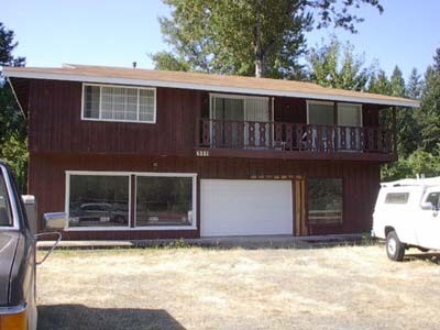
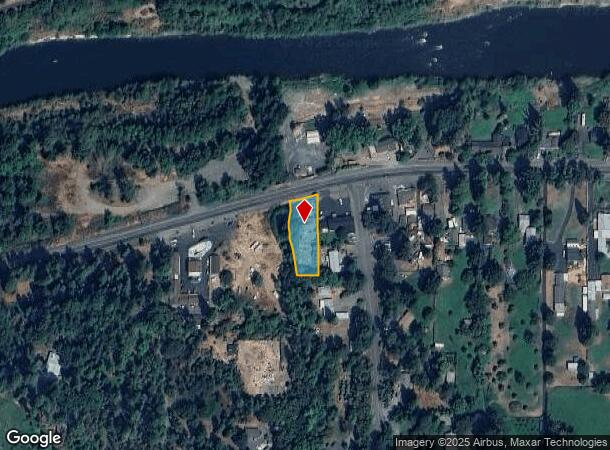
Property Record
6351 Rogue River Hwy, Grants Pass, OR 97527
NEARBY LISTINGS FOR SALE OR LEASE
-
-
View all Grants Pass listings for sale on LoopNet.com
Property Detail
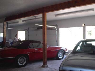
6351 Rogue River Hwy
Commercialbuilding
Jackson
AE
Oregon
41029C1711F
0.39 AC
2024
Other Market Areas
2025
Medford, OR
003001
10303228
2,112 SF
DEMOGRAPHICS near 6351 Rogue River Hwy
1 Mile
3 Mile
5 Mile
2024 Total Population
583
4,085
17,535
2029 Population
571
4,037
17,526
Pop Growth 2024-2029
(2.06%)
(1.18%)
(0.05%)
Average Age
49
49
46
2024 Total Households
261
1,836
7,425
HH Growth 2024-2029
(2.30%)
(1.25%)
(0.11%)
Median Household Inc
$59,473
$46,146
$49,086
Avg Household Size
2.20
2.20
2.30
2024 Avg HH Vehicles
2.00
2.00
2.00
Median Home Value
$445,614
$377,056
$372,744
Median Year Built
1974
1977
1977
Nearby Places
Map Layers
Map Styles
 Street
 Aerial
- Restaurants
- Banks
- Shops
- Fitness
- Groceries
PUBLIC TRANSPORTATION
AIRPORT
Rogue Valley International - Medford
DRIVE
WALK
Distance
Rogue Valley International - Medford
28 min
21.1 mi
Freight Ports
Port of Coos Bay, OR
DRIVE
WALK
Distance
Port of Coos Bay, OR
195 min
143.9 mi
SALE & LEASE HISTORY
LISTING DATE
SALE/LEASE

May 10, 2017
For Sale
Mar 08, 2017
For Sale
Nearby Properties
Address
Land Use
TOTAL SIZE
Lot Size
Zoning
Address
Land Use
TOTAL SIZE
Lot Size
Zoning
2,952 SF
2.75 AC
RR1
Address
Land Use
TOTAL SIZE
Lot Size
Zoning
70,403 SF
9.57 AC
C-1
Address
Land Use
TOTAL SIZE
Lot Size
Zoning
31,045 SF
1.93 AC
P
Address
Land Use
TOTAL SIZE
Lot Size
Zoning
2.20 AC
C-1
Address
Land Use
TOTAL SIZE
Lot Size
Zoning
3.71 AC
RI
Address
Land Use
TOTAL SIZE
Lot Size
Zoning
6.78 AC
M-1
Address
Land Use
TOTAL SIZE
Lot Size
Zoning
26,304 SF
1.23 AC
C-1
Address
Land Use
TOTAL SIZE
Lot Size
Zoning
Address
Land Use
TOTAL SIZE
Lot Size
Zoning
6.84 AC
M-1
Address
Land Use
TOTAL SIZE
Lot Size
Zoning
3.71 AC
RI
Address
Land Use
TOTAL SIZE
Lot Size
Zoning
1.26 AC
C-1
Address
Land Use
TOTAL SIZE
Lot Size
Zoning
12,136 SF
2.37 AC
P
Address
Land Use
TOTAL SIZE
Lot Size
Zoning
5,602 SF
3 AC
RC
Address
Land Use
TOTAL SIZE
Lot Size
Zoning
655.22 AC
FR
Address
Land Use
TOTAL SIZE
Lot Size
Zoning
782 SF
1.70 AC
C-1
Address
Land Use
TOTAL SIZE
Lot Size
Zoning
440 AC
FR
Address
Land Use
TOTAL SIZE
Lot Size
Zoning
8,286 SF
8.07 AC
RR-5
Address
Land Use
TOTAL SIZE
Lot Size
Zoning
2,138 SF
5.23 AC
R 1-6
Address
Land Use
TOTAL SIZE
Lot Size
Zoning
722.94 AC
FR
Address
Land Use
TOTAL SIZE
Lot Size
Zoning
3.51 AC
RR-5
Address
Land Use
TOTAL SIZE
Lot Size
Zoning
13,200 SF
0.73 AC
P
Address
Land Use
TOTAL SIZE
Lot Size
Zoning
15,128 SF
0.74 AC
R-2
Address
Land Use
TOTAL SIZE
Lot Size
Zoning
5,215 SF
12.60 AC
FR
Address
Land Use
TOTAL SIZE
Lot Size
Zoning
449.72 AC
FR
Address
Land Use
TOTAL SIZE
Lot Size
Zoning
7,104 SF
1.06 AC
C-1
Address
Land Use
TOTAL SIZE
Lot Size
Zoning
436.64 AC
FR
Address
Land Use
TOTAL SIZE
Lot Size
Zoning
23 AC
RR1
Address
Land Use
TOTAL SIZE
Lot Size
Zoning
7,003 SF
5.84 AC
RR1
Address
Land Use
TOTAL SIZE
Lot Size
Zoning
8,000 SF
1.06 AC
R-2
Address
Land Use
TOTAL SIZE
Lot Size
Zoning
440 SF
5.11 AC
RR5
The World's #1 Commercial Real Estate Marketplace
Connect with us
© 2025 CoStar Group
The information above has been obtained from sources believed reliable. While we do not doubt its accuracy we have not verified it and make no guarantee, warranty or representation about it. It is your responsibility to independently confirm its accuracy and completeness. Any projections, opinions, assumptions, or estimates used are for example only and do not represent the current or future performance of the property. The value of this transaction to you depends on tax and other factors which should be evaluated by your tax, financial, and legal advisors. You and your advisors should conduct a careful, independent investigation of the property to determine to your satisfaction the suitability of the property for your needs.