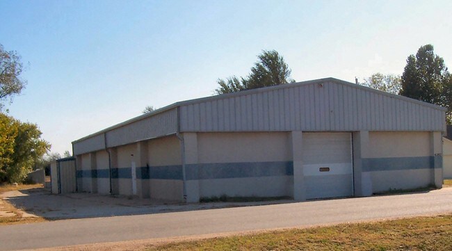
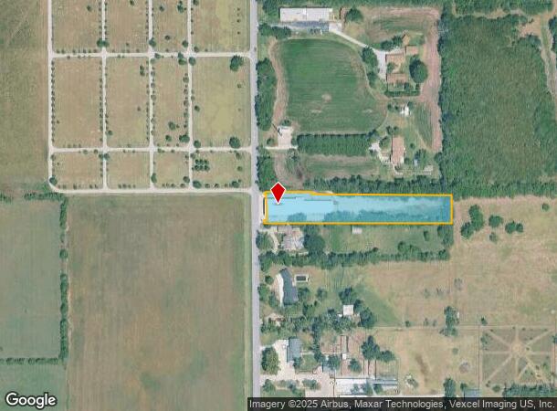
Property Record
6352 N Hillside Ave, Wichita, KS 67219

NEARBY LISTINGS FOR SALE OR LEASE
Property Detail
6352 N Hillside Ave
091-11-0-33-00-001.00
BEG NW COR SW1/4 SW1/4 S 93 FT E 660 FT N 93 FT W 473 FT N 7 FT W 187 FT S 7 FT TO BEG EXC FOR ST SEC 11-26-1E
Warehouse
Sedgwick
X
Kansas
20173C0216G
1.41 AC
2024
Park City/North
2025
Wichita
010113
Wichita, KS
10,547 SF
DEMOGRAPHICS near 6352 N Hillside Ave
1 Mile
3 Mile
5 Mile
2024 Total Population
3,706
15,301
50,402
2029 Population
3,762
15,468
50,846
Pop Growth 2024-2029
+ 1.51%
+ 1.09%
+ 0.88%
Average Age
38
37
38
2024 Total Households
1,391
5,623
19,250
HH Growth 2024-2029
+ 1.44%
+ 1.01%
+ 0.74%
Median Household Inc
$82,750
$82,500
$73,157
Avg Household Size
2.70
2.70
2.60
2024 Avg HH Vehicles
2.00
2.00
2.00
Median Home Value
$174,630
$176,352
$184,585
Median Year Built
1990
1994
1989
Nearby Places
Map Layers
Map Styles
 Street
 Aerial
- Restaurants
- Banks
- Shops
- Fitness
- Groceries
PUBLIC TRANSPORTATION
AIRPORT
Wichita Dwight D Eisenhower Ntl
DRIVE
WALK
Distance
Wichita Dwight D Eisenhower Ntl
24 min
15.3 mi
Freight Ports
Tulsa Port Of Catoosa
DRIVE
WALK
Distance
Tulsa Port Of Catoosa
217 min
201.1 mi
SALE & LEASE HISTORY
LISTING DATE
SALE/LEASE

Oct 30, 2017
For Sale
Mar 18, 2021
For Sale
Jun 04, 2021
For Lease
Nearby Properties
Address
Land Use
TOTAL SIZE
Lot Size
Zoning
Address
Land Use
TOTAL SIZE
Lot Size
Zoning
924,000 SF
58.58 AC
SF-20
Address
Land Use
TOTAL SIZE
Lot Size
Zoning
304,863 SF
74.13 AC
SF5
Address
Land Use
TOTAL SIZE
Lot Size
Zoning
129,965 SF
41.88 AC
R3
Address
Land Use
TOTAL SIZE
Lot Size
Zoning
1,079,902 SF
68.86 AC
Address
Land Use
TOTAL SIZE
Lot Size
Zoning
79,739 SF
10.11 AC
R6
Address
Land Use
TOTAL SIZE
Lot Size
Zoning
147,784 SF
39.28 AC
SF-5
Address
Land Use
TOTAL SIZE
Lot Size
Zoning
252,450 SF
17.48 AC
Address
Land Use
TOTAL SIZE
Lot Size
Zoning
40,267 SF
10.55 AC
R6
Address
Land Use
TOTAL SIZE
Lot Size
Zoning
92,735 SF
7.28 AC
R4
Address
Land Use
TOTAL SIZE
Lot Size
Zoning
292,500 SF
12.15 AC
LI
Address
Land Use
TOTAL SIZE
Lot Size
Zoning
34,050 SF
10.23 AC
Address
Land Use
TOTAL SIZE
Lot Size
Zoning
76,382 SF
8.77 AC
R4
Address
Land Use
TOTAL SIZE
Lot Size
Zoning
52,156 SF
5.89 AC
R6
Address
Land Use
TOTAL SIZE
Lot Size
Zoning
91,702 SF
53.96 AC
I-1
Address
Land Use
TOTAL SIZE
Lot Size
Zoning
94,251 SF
6.46 AC
C2
Address
Land Use
TOTAL SIZE
Lot Size
Zoning
76,039 SF
9.43 AC
R2
Address
Land Use
TOTAL SIZE
Lot Size
Zoning
33,505 SF
4.75 AC
R6
Address
Land Use
TOTAL SIZE
Lot Size
Zoning
99,564 SF
31.31 AC
I1
Address
Land Use
TOTAL SIZE
Lot Size
Zoning
61,349 SF
6.91 AC
I1
Address
Land Use
TOTAL SIZE
Lot Size
Zoning
33,361 SF
3.63 AC
Address
Land Use
TOTAL SIZE
Lot Size
Zoning
451,477 SF
58.44 AC
I1
Address
Land Use
TOTAL SIZE
Lot Size
Zoning
18,905 SF
1.96 AC
Address
Land Use
TOTAL SIZE
Lot Size
Zoning
26,119 SF
3.63 AC
AA
Address
Land Use
TOTAL SIZE
Lot Size
Zoning
35,000 SF
16.26 AC
Address
Land Use
TOTAL SIZE
Lot Size
Zoning
20,969 SF
8.85 AC
I-1
Address
Land Use
TOTAL SIZE
Lot Size
Zoning
349,549 SF
19.11 AC
I1
Address
Land Use
TOTAL SIZE
Lot Size
Zoning
82,879 SF
35.73 AC
GC
Address
Land Use
TOTAL SIZE
Lot Size
Zoning
207,808 SF
1.15 AC
I1
Address
Land Use
TOTAL SIZE
Lot Size
Zoning
27,207 SF
9.78 AC
The World's #1 Commercial Real Estate Marketplace
Connect with us
© 2025 CoStar Group
The information above has been obtained from sources believed reliable. While we do not doubt its accuracy we have not verified it and make no guarantee, warranty or representation about it. It is your responsibility to independently confirm its accuracy and completeness. Any projections, opinions, assumptions, or estimates used are for example only and do not represent the current or future performance of the property. The value of this transaction to you depends on tax and other factors which should be evaluated by your tax, financial, and legal advisors. You and your advisors should conduct a careful, independent investigation of the property to determine to your satisfaction the suitability of the property for your needs.