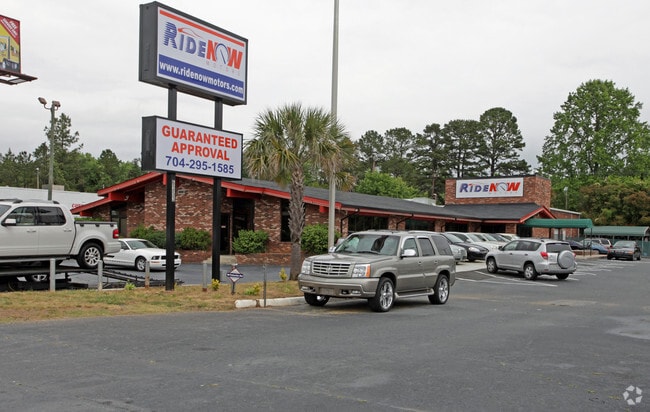
Property Record
6353 E Independence Blvd, Charlotte, NC 28212

Current Lease Availabilities
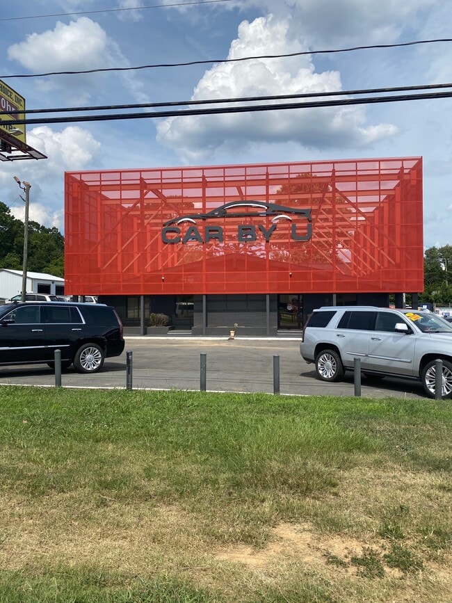
NEARBY LISTINGS FOR SALE OR LEASE
Property Detail
6353 E Independence Blvd
Charlotte-Concord-Gastonia, NC-SC
Gus Nixon
165-111-23
TRACT 2 U/M
Commercialnec
Mecklenburg
X
North Carolina
3710457200K
23
2024
0.72 AC
2025
East
001919
Charlotte
8,303 SF
DEMOGRAPHICS near 6353 E Independence Blvd
1 Mile
3 Mile
5 Mile
2024 Total Population
12,812
99,499
240,204
2029 Population
13,446
104,541
253,132
Pop Growth 2024-2029
+ 4.95%
+ 5.07%
+ 5.38%
Average Age
35
37
38
2024 Total Households
5,023
39,972
96,826
HH Growth 2024-2029
+ 5.00%
+ 5.15%
+ 5.48%
Median Household Inc
$54,337
$59,187
$69,080
Avg Household Size
2.50
2.40
2.40
2024 Avg HH Vehicles
2.00
2.00
2.00
Median Home Value
$203,065
$283,040
$353,357
Median Year Built
1978
1980
1982
Nearby Places
Map Layers
Map Styles
 Street
 Aerial
- Restaurants
- Banks
- Shops
- Fitness
- Groceries
PUBLIC TRANSPORTATION
AIRPORT
Charlotte/Douglas International
DRIVE
WALK
Distance
Charlotte/Douglas International
25 min
14.6 mi
Concord-Padgett Regional
DRIVE
WALK
Distance
Concord-Padgett Regional
29 min
19.2 mi
Nearby Properties
Address
Land Use
TOTAL SIZE
Lot Size
Zoning
Address
Land Use
TOTAL SIZE
Lot Size
Zoning
287,182 SF
21.73 AC
CC
Address
Land Use
TOTAL SIZE
Lot Size
Zoning
382,175 SF
31.67 AC
R12MFCD
Address
Land Use
TOTAL SIZE
Lot Size
Zoning
362,388 SF
26.88 AC
R12MFCD
Address
Land Use
TOTAL SIZE
Lot Size
Zoning
282,780 SF
21.75 AC
R17MF
Address
Land Use
TOTAL SIZE
Lot Size
Zoning
333,218 SF
22.86 AC
R17MF
Address
Land Use
TOTAL SIZE
Lot Size
Zoning
292,066 SF
2.67 AC
R15MF
Address
Land Use
TOTAL SIZE
Lot Size
Zoning
232,858 SF
21.74 AC
R15MF
Address
Land Use
TOTAL SIZE
Lot Size
Zoning
258,272 SF
22.10 AC
R9MFCD
Address
Land Use
TOTAL SIZE
Lot Size
Zoning
299,998 SF
19.55 AC
R17MF
Address
Land Use
TOTAL SIZE
Lot Size
Zoning
325,177 SF
43.11 AC
R12MFCD
Address
Land Use
TOTAL SIZE
Lot Size
Zoning
347,952 SF
28.37 AC
OACUD
Address
Land Use
TOTAL SIZE
Lot Size
Zoning
300,346 SF
45.50 AC
R3
Address
Land Use
TOTAL SIZE
Lot Size
Zoning
218,876 SF
14.82 AC
R6MFCD
Address
Land Use
TOTAL SIZE
Lot Size
Zoning
324,323 SF
31.39 AC
R17MF
Address
Land Use
TOTAL SIZE
Lot Size
Zoning
316,763 SF
21.18 AC
R17MF
Address
Land Use
TOTAL SIZE
Lot Size
Zoning
212,628 SF
6.01 AC
R3
Address
Land Use
TOTAL SIZE
Lot Size
Zoning
254,671 SF
16.10 AC
R12MFCD
Address
Land Use
TOTAL SIZE
Lot Size
Zoning
246,624 SF
24.06 AC
R17MF
Address
Land Use
TOTAL SIZE
Lot Size
Zoning
177,643 SF
25 AC
R3
Address
Land Use
TOTAL SIZE
Lot Size
Zoning
255,404 SF
17.76 AC
R12MFCD
Address
Land Use
TOTAL SIZE
Lot Size
Zoning
208,960 SF
7.33 AC
MUDDO
Address
Land Use
TOTAL SIZE
Lot Size
Zoning
270,091 SF
32.43 AC
R17MF
Address
Land Use
TOTAL SIZE
Lot Size
Zoning
322,517 SF
30.74 AC
R15MFCD
Address
Land Use
TOTAL SIZE
Lot Size
Zoning
197,180 SF
4.89 AC
Address
Land Use
TOTAL SIZE
Lot Size
Zoning
208,846 SF
14.99 AC
R17MF
Address
Land Use
TOTAL SIZE
Lot Size
Zoning
215,246 SF
14.49 AC
R3
Address
Land Use
TOTAL SIZE
Lot Size
Zoning
197,367 SF
6.07 AC
Address
Land Use
TOTAL SIZE
Lot Size
Zoning
142,300 SF
5.50 AC
Address
Land Use
TOTAL SIZE
Lot Size
Zoning
205,701 SF
13.73 AC
OACUD
Address
Land Use
TOTAL SIZE
Lot Size
Zoning
249,650 SF
20.17 AC
R17MF
The World's #1 Commercial Real Estate Marketplace
Connect with us
© 2025 CoStar Group
The information above has been obtained from sources believed reliable. While we do not doubt its accuracy we have not verified it and make no guarantee, warranty or representation about it. It is your responsibility to independently confirm its accuracy and completeness. Any projections, opinions, assumptions, or estimates used are for example only and do not represent the current or future performance of the property. The value of this transaction to you depends on tax and other factors which should be evaluated by your tax, financial, and legal advisors. You and your advisors should conduct a careful, independent investigation of the property to determine to your satisfaction the suitability of the property for your needs.