Property Record
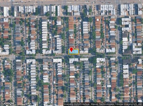
6357 S Francisco Ave, Chicago, IL 60629
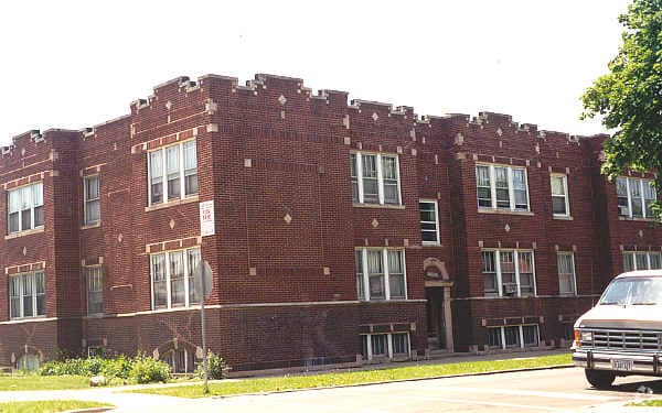
This Property Is For Sale
NEARBY LISTINGS FOR SALE OR LEASE
Property Detail
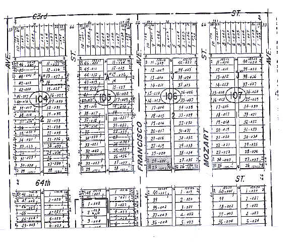
6357 S Francisco Ave
19-24-106-021-0000
John Bains
Apartment
Cook
X
Illinois
17031C0515J
24,25
2023
0.17 AC
2024
Marquette Park
660600
Chicago
9,108 SF
Chicago-Naperville-Elgin, IL-IN-WI
DEMOGRAPHICS near 6357 S Francisco Ave
1 Mile
3 Mile
5 Mile
2024 Total Population
47,160
291,215
654,754
2029 Population
44,000
273,317
619,147
Pop Growth 2024-2029
(6.70%)
(6.15%)
(5.44%)
Average Age
35
37
38
2024 Total Households
13,792
89,928
222,219
HH Growth 2024-2029
(7.13%)
(6.40%)
(5.62%)
Median Household Inc
$36,657
$43,091
$48,387
Avg Household Size
3.30
3.10
2.80
2024 Avg HH Vehicles
1.00
1.00
1.00
Median Home Value
$179,791
$190,810
$216,422
Median Year Built
1949
1949
1950
Nearby Places
- Restaurants
- Banks
- Shops
- Fitness
- Groceries
PUBLIC TRANSPORTATION
COMMUTER RAIL
Wrightwood Station (SouthWest Service - Northeast Illinois Regional Commuter Railroad (Metra))
DRIVE
WALK
Distance
Wrightwood Station (SouthWest Service - Northeast Illinois Regional Commuter Railroad (Metra))
6 min
2.6 mi
Ashburn Station (SouthWest Service - Northeast Illinois Regional Commuter Railroad (Metra))
DRIVE
WALK
Distance
Ashburn Station (SouthWest Service - Northeast Illinois Regional Commuter Railroad (Metra))
7 min
3.4 mi
AIRPORT
Chicago Midway International
DRIVE
WALK
Distance
Chicago Midway International
9 min
4.4 mi
Chicago O'Hare International
DRIVE
WALK
Distance
Chicago O'Hare International
42 min
25.1 mi
Nearby Properties
Address
Land Use
TOTAL SIZE
Lot Size
Zoning
Address
Land Use
TOTAL SIZE
Lot Size
Zoning
4.71 AC
PD 1196
Address
Land Use
TOTAL SIZE
Lot Size
Zoning
2.98 AC
PD 1196
Address
Land Use
TOTAL SIZE
Lot Size
Zoning
134,800 SF
2.53 AC
PD 1273
Address
Land Use
TOTAL SIZE
Lot Size
Zoning
1,269,112 SF
39.99 AC
M2-1
Address
Land Use
TOTAL SIZE
Lot Size
Zoning
2,155,128 SF
63.23 AC
PMD13
Address
Land Use
TOTAL SIZE
Lot Size
Zoning
0.91 AC
PD 1177
Address
Land Use
TOTAL SIZE
Lot Size
Zoning
87,830 SF
0.76 AC
B1-1
Address
Land Use
TOTAL SIZE
Lot Size
Zoning
798,998 SF
B3-2
Address
Land Use
TOTAL SIZE
Lot Size
Zoning
124,324 SF
11.26 AC
Address
Land Use
TOTAL SIZE
Lot Size
Zoning
0.84 AC
B1-3
Address
Land Use
TOTAL SIZE
Lot Size
Zoning
633,057 SF
34.96 AC
PMD 8
Address
Land Use
TOTAL SIZE
Lot Size
Zoning
796,454 SF
25.68 AC
PMD13
Address
Land Use
TOTAL SIZE
Lot Size
Zoning
1,615,006 SF
41.91 AC
PMD13
Address
Land Use
TOTAL SIZE
Lot Size
Zoning
139,493 SF
9.06 AC
PD 965
Address
Land Use
TOTAL SIZE
Lot Size
Zoning
131,261 SF
7.04 AC
PD 172
Address
Land Use
TOTAL SIZE
Lot Size
Zoning
151,303 SF
0.88 AC
PD 568
Address
Land Use
TOTAL SIZE
Lot Size
Zoning
1.65 AC
B2-3
Address
Land Use
TOTAL SIZE
Lot Size
Zoning
134,078 SF
17.31 AC
Address
Land Use
TOTAL SIZE
Lot Size
Zoning
102,534 SF
3.87 AC
Address
Land Use
TOTAL SIZE
Lot Size
Zoning
148,474 SF
17.68 AC
Address
Land Use
TOTAL SIZE
Lot Size
Zoning
93,438 SF
3.13 AC
Address
Land Use
TOTAL SIZE
Lot Size
Zoning
86,703 SF
3.37 AC
Address
Land Use
TOTAL SIZE
Lot Size
Zoning
435,677 SF
12.37 AC
M1-2
Address
Land Use
TOTAL SIZE
Lot Size
Zoning
101,034 SF
1.92 AC
Address
Land Use
TOTAL SIZE
Lot Size
Zoning
90,808 SF
3.27 AC
Address
Land Use
TOTAL SIZE
Lot Size
Zoning
127,197 SF
10.43 AC
Address
Land Use
TOTAL SIZE
Lot Size
Zoning
85,990 SF
6.46 AC
PD 411
Address
Land Use
TOTAL SIZE
Lot Size
Zoning
352,529 SF
12.77 AC
PMD 8
Address
Land Use
TOTAL SIZE
Lot Size
Zoning
99,900 SF
12.45 AC
PD 1172
Address
Land Use
TOTAL SIZE
Lot Size
Zoning
55,492 SF
3.35 AC
B3-3
The World's #1 Commercial Real Estate Marketplace
Connect with us
© 2025 CoStar Group
The information above has been obtained from sources believed reliable. While we do not doubt its accuracy we have not verified it and make no guarantee, warranty or representation about it. It is your responsibility to independently confirm its accuracy and completeness. Any projections, opinions, assumptions, or estimates used are for example only and do not represent the current or future performance of the property. The value of this transaction to you depends on tax and other factors which should be evaluated by your tax, financial, and legal advisors. You and your advisors should conduct a careful, independent investigation of the property to determine to your satisfaction the suitability of the property for your needs.