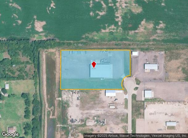
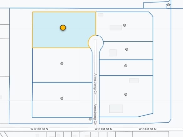
Property Record
6355 N Armstrong Cir, Wichita, KS 67204
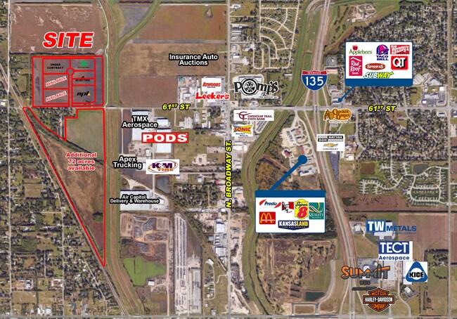
NEARBY LISTINGS FOR SALE OR LEASE
Property Detail
6355 N Armstrong Cir
Wichita, KS
Air Capitol Industrial Park 2Nd Add
093-08-0-34-01-006.00
LOT 3 BLOCK 1 AIR CAPITOL INDUSTRIAL PARK 2ND ADDITION
Warehouse
Sedgwick
AE
Kansas
20173C0211G
3
2024
6.07 AC
2025
Park City/North
008100
Wichita
26,000 SF
DEMOGRAPHICS near 6355 N Armstrong Cir
1 Mile
3 Mile
5 Mile
2024 Total Population
1,713
18,402
42,943
2029 Population
1,744
18,668
43,511
Pop Growth 2024-2029
+ 1.81%
+ 1.45%
+ 1.32%
Average Age
40
39
38
2024 Total Households
639
6,858
15,755
HH Growth 2024-2029
+ 1.72%
+ 1.37%
+ 1.26%
Median Household Inc
$77,355
$73,642
$71,854
Avg Household Size
2.60
2.70
2.70
2024 Avg HH Vehicles
3.00
2.00
2.00
Median Home Value
$179,891
$185,851
$178,674
Median Year Built
1975
1982
1978
Nearby Places
Map Layers
Map Styles
 Street
 Aerial
- Restaurants
- Banks
- Shops
- Fitness
- Groceries
PUBLIC TRANSPORTATION
AIRPORT
Wichita Dwight D Eisenhower Ntl
DRIVE
WALK
Distance
Wichita Dwight D Eisenhower Ntl
23 min
13.0 mi
Freight Ports
Tulsa Port Of Catoosa
DRIVE
WALK
Distance
Tulsa Port Of Catoosa
216 min
201.1 mi
SALE & LEASE HISTORY
LISTING DATE
SALE/LEASE

Aug 30, 2019
For Sale
Nearby Properties
Address
Land Use
TOTAL SIZE
Lot Size
Zoning
Address
Land Use
TOTAL SIZE
Lot Size
Zoning
924,000 SF
58.58 AC
SF-20
Address
Land Use
TOTAL SIZE
Lot Size
Zoning
1,079,902 SF
68.86 AC
Address
Land Use
TOTAL SIZE
Lot Size
Zoning
252,450 SF
17.48 AC
Address
Land Use
TOTAL SIZE
Lot Size
Zoning
292,500 SF
12.15 AC
LI
Address
Land Use
TOTAL SIZE
Lot Size
Zoning
60,945 SF
14.20 AC
SF-5
Address
Land Use
TOTAL SIZE
Lot Size
Zoning
34,050 SF
10.23 AC
Address
Land Use
TOTAL SIZE
Lot Size
Zoning
87,018 SF
8.38 AC
LC
Address
Land Use
TOTAL SIZE
Lot Size
Zoning
94,251 SF
6.46 AC
C2
Address
Land Use
TOTAL SIZE
Lot Size
Zoning
76,039 SF
9.43 AC
R2
Address
Land Use
TOTAL SIZE
Lot Size
Zoning
25,748 SF
14.90 AC
MF-18
Address
Land Use
TOTAL SIZE
Lot Size
Zoning
52,947 SF
42.43 AC
B
Address
Land Use
TOTAL SIZE
Lot Size
Zoning
45,868 SF
9.07 AC
R2
Address
Land Use
TOTAL SIZE
Lot Size
Zoning
99,564 SF
31.31 AC
I1
Address
Land Use
TOTAL SIZE
Lot Size
Zoning
36,825 SF
10.47 AC
LC,SF-5
Address
Land Use
TOTAL SIZE
Lot Size
Zoning
61,349 SF
6.91 AC
I1
Address
Land Use
TOTAL SIZE
Lot Size
Zoning
33,361 SF
3.63 AC
Address
Land Use
TOTAL SIZE
Lot Size
Zoning
451,477 SF
58.44 AC
I1
Address
Land Use
TOTAL SIZE
Lot Size
Zoning
18,905 SF
1.96 AC
Address
Land Use
TOTAL SIZE
Lot Size
Zoning
26,119 SF
3.63 AC
AA
Address
Land Use
TOTAL SIZE
Lot Size
Zoning
15,370 SF
4.34 AC
R2
Address
Land Use
TOTAL SIZE
Lot Size
Zoning
35,000 SF
16.26 AC
Address
Land Use
TOTAL SIZE
Lot Size
Zoning
349,549 SF
19.11 AC
I1
Address
Land Use
TOTAL SIZE
Lot Size
Zoning
17,346 SF
16.47 AC
Address
Land Use
TOTAL SIZE
Lot Size
Zoning
198,498 SF
15.50 AC
LC
Address
Land Use
TOTAL SIZE
Lot Size
Zoning
82,879 SF
35.73 AC
GC
Address
Land Use
TOTAL SIZE
Lot Size
Zoning
207,808 SF
1.15 AC
I1
Address
Land Use
TOTAL SIZE
Lot Size
Zoning
27,207 SF
9.78 AC
Address
Land Use
TOTAL SIZE
Lot Size
Zoning
272,864 SF
5.40 AC
I1
Address
Land Use
TOTAL SIZE
Lot Size
Zoning
15,360 SF
0.57 AC
CVCP*
The World's #1 Commercial Real Estate Marketplace
Connect with us
© 2026 CoStar Group
The information above has been obtained from sources believed reliable. While we do not doubt its accuracy we have not verified it and make no guarantee, warranty or representation about it. It is your responsibility to independently confirm its accuracy and completeness. Any projections, opinions, assumptions, or estimates used are for example only and do not represent the current or future performance of the property. The value of this transaction to you depends on tax and other factors which should be evaluated by your tax, financial, and legal advisors. You and your advisors should conduct a careful, independent investigation of the property to determine to your satisfaction the suitability of the property for your needs.