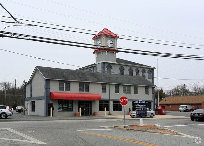
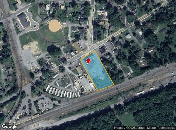
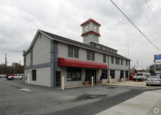
Property Record
636 Broad St, Perryville, MD 21903
NEARBY LISTINGS FOR SALE OR LEASE
Property Detail
636 Broad St
07-019858
Village Perryville
Commercialofficeresidentialmixeduse
1.602 ACRE 636 BROAD STREET PERRYVILLE
X
Cecil
24025C0212E
Maryland
2025
1.60 AC
2025
Cecil County
031202
Baltimore
17,482 SF
Philadelphia-Camden-Wilmington, PA-NJ-DE-MD
DEMOGRAPHICS near 636 Broad St
1 Mile
3 Mile
5 Mile
2024 Total Population
2,931
18,945
30,524
2029 Population
2,967
19,517
31,522
Pop Growth 2024-2029
+ 1.23%
+ 3.02%
+ 3.27%
Average Age
45
43
44
2024 Total Households
1,215
7,859
12,498
HH Growth 2024-2029
+ 1.15%
+ 3.21%
+ 3.44%
Median Household Inc
$56,262
$74,424
$83,081
Avg Household Size
2.20
2.40
2.40
2024 Avg HH Vehicles
2.00
2.00
2.00
Median Home Value
$281,141
$286,306
$299,562
Median Year Built
1981
1981
1986
Nearby Places
Map Layers
Map Styles
 Street
 Aerial
- Restaurants
- Banks
- Shops
- Fitness
- Groceries
PUBLIC TRANSPORTATION
COMMUTER RAIL
Perryville (PENN - WASHINGTON - Maryland Area Regional Commuter Trains (The MARC), Penn Line - Maryland Area Regional Commuter Trains (The MARC))
DRIVE
WALK
Distance
Perryville (PENN - WASHINGTON - Maryland Area Regional Commuter Trains (The MARC), Penn Line - Maryland Area Regional Commuter Trains (The MARC))
1 min
4 min
0.3 mi
Aberdeen (PENN - WASHINGTON - Maryland Area Regional Commuter Trains (The MARC), Penn Line - Maryland Area Regional Commuter Trains (The MARC))
DRIVE
WALK
Distance
Aberdeen (PENN - WASHINGTON - Maryland Area Regional Commuter Trains (The MARC), Penn Line - Maryland Area Regional Commuter Trains (The MARC))
14 min
7.6 mi
Freight Ports
Port of Wilmington, RI
DRIVE
WALK
Distance
Port of Wilmington, RI
45 min
34.4 mi
SALE & LEASE HISTORY
LISTING DATE
SALE/LEASE

Sep 25, 2016
For Lease
Sep 24, 2016
For Sale
Nearby Properties
Address
Land Use
TOTAL SIZE
Lot Size
Zoning
Address
Land Use
TOTAL SIZE
Lot Size
Zoning
457,324 SF
43.13 AC
C2/L2
Address
Land Use
TOTAL SIZE
Lot Size
Zoning
866,826 SF
267.48 AC
L2
Address
Land Use
TOTAL SIZE
Lot Size
Zoning
349.76 AC
OS
Address
Land Use
TOTAL SIZE
Lot Size
Zoning
2,589 SF
57.19 AC
R2
Address
Land Use
TOTAL SIZE
Lot Size
Zoning
68,345 SF
30.07 AC
CEMUD
Address
Land Use
TOTAL SIZE
Lot Size
Zoning
149,622 SF
9.30 AC
GI
Address
Land Use
TOTAL SIZE
Lot Size
Zoning
100,444 SF
2.64 AC
RB
Address
Land Use
TOTAL SIZE
Lot Size
Zoning
113,412 SF
108 AC
R2
Address
Land Use
TOTAL SIZE
Lot Size
Zoning
103,470 SF
5.97 AC
R1
Address
Land Use
TOTAL SIZE
Lot Size
Zoning
28.03 AC
OS
Address
Land Use
TOTAL SIZE
Lot Size
Zoning
65,006 SF
29.63 AC
R1
Address
Land Use
TOTAL SIZE
Lot Size
Zoning
140,316 SF
36.71 AC
RM
Address
Land Use
TOTAL SIZE
Lot Size
Zoning
58,603 SF
13.26 AC
R1
Address
Land Use
TOTAL SIZE
Lot Size
Zoning
1,270 SF
61.42 AC
C
Address
Land Use
TOTAL SIZE
Lot Size
Zoning
213,790 SF
1.37 AC
RB
Address
Land Use
TOTAL SIZE
Lot Size
Zoning
184,116 SF
18.45 AC
GI
Address
Land Use
TOTAL SIZE
Lot Size
Zoning
4,800 SF
14.81 AC
C2
Address
Land Use
TOTAL SIZE
Lot Size
Zoning
18,944 SF
7.11 AC
GI
Address
Land Use
TOTAL SIZE
Lot Size
Zoning
24,000 SF
2.24 AC
C2
Address
Land Use
TOTAL SIZE
Lot Size
Zoning
20,000 SF
11.32 AC
RB
Address
Land Use
TOTAL SIZE
Lot Size
Zoning
55,825 SF
10.25 AC
RB
Address
Land Use
TOTAL SIZE
Lot Size
Zoning
20,674 SF
0.54 AC
RO
Address
Land Use
TOTAL SIZE
Lot Size
Zoning
31,116 SF
9.37 AC
C
Address
Land Use
TOTAL SIZE
Lot Size
Zoning
7,586 SF
2.20 AC
RO
Address
Land Use
TOTAL SIZE
Lot Size
Zoning
39,126 SF
3.96 AC
C
Address
Land Use
TOTAL SIZE
Lot Size
Zoning
11,749 SF
10.62 AC
GI
Address
Land Use
TOTAL SIZE
Lot Size
Zoning
24,000 SF
2.16 AC
C2
Address
Land Use
TOTAL SIZE
Lot Size
Zoning
15,344 SF
4.96 AC
MUD
Address
Land Use
TOTAL SIZE
Lot Size
Zoning
118,242 SF
10.11 AC
GI
Address
Land Use
TOTAL SIZE
Lot Size
Zoning
2,496 SF
20.39 AC
ST
The World's #1 Commercial Real Estate Marketplace
Connect with us
© 2026 CoStar Group
The information above has been obtained from sources believed reliable. While we do not doubt its accuracy we have not verified it and make no guarantee, warranty or representation about it. It is your responsibility to independently confirm its accuracy and completeness. Any projections, opinions, assumptions, or estimates used are for example only and do not represent the current or future performance of the property. The value of this transaction to you depends on tax and other factors which should be evaluated by your tax, financial, and legal advisors. You and your advisors should conduct a careful, independent investigation of the property to determine to your satisfaction the suitability of the property for your needs.