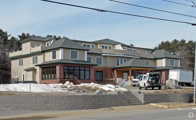
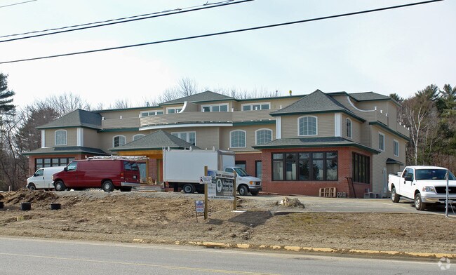
Property Record
636 Post Rd, Wells, ME 04090

Property Detail
636 Post Rd
WLLS-000114-000000-000009
York
Commercialofficeresidentialmixeduse
Maine
GB
9
B and X Area of moderate flood hazard, usually the area between the limits of the 100-year and 500-year floods.
1.50 AC
2025
York County
2025
Portland/South Portland
034004
Portland-South Portland, ME
12,556 SF
NEARBY LISTINGS FOR SALE OR LEASE
DEMOGRAPHICS near 636 Post Rd
1 mile
3 mile
5 mile
2025 Total Population
1,781
7,473
12,785
2030 Population
1,938
7,960
13,515
Pop Growth 2025-2030
+ 8.82%
+ 6.52%
+ 5.71%
Average Age
55
53
52
2025 Total Households
885
3,627
5,989
HH Growth 2025-2030
+ 8.81%
+ 6.51%
+ 5.73%
Median Household Inc
$73,598
$84,772
$92,940
Avg Household Size
2.00
2.00
2.10
2025 Avg HH Vehicles
2.00
2.00
2.00
Median Home Value
$672,672
$638,974
$619,754
Median Year Built
1987
1987
1988
Nearby Places
Map Layers
Map Styles
 Street
 Aerial
Transit
 Traffic
 Biking
Places
Listings with unknown addresses are not visible on the map
- Restaurants
- Banks
- Shops
- Fitness
- Groceries
PUBLIC TRANSPORTATION
COMMUTER RAIL
Drive
Walk
Distance
8 min
3.3 mi
AIRPORT
Portsmouth International at Pease
Drive
Walk
Distance
Portsmouth International at Pease
36 min
25.9 mi
Portland International Jetport
Drive
Walk
Distance
Portland International Jetport
43 min
31.6 mi
Freight Ports
Portland, ME
Drive
Walk
Distance
Portland, ME
44 min
34.1 mi
Nearby Properties
Address
Land Use
TOTAL SIZE
Lot Size
Zoning
Address
Land Use
TOTAL SIZE
Lot Size
Zoning
86,468 SF
53.99 AC
GB
Address
Land Use
TOTAL SIZE
Lot Size
Zoning
Address
Land Use
TOTAL SIZE
Lot Size
Zoning
381,495 SF
44.05 AC
LI
Address
Land Use
TOTAL SIZE
Lot Size
Zoning
76,411 SF
84.80 AC
RA
Address
Land Use
TOTAL SIZE
Lot Size
Zoning
71,230 SF
11.81 AC
RC
Address
Land Use
TOTAL SIZE
Lot Size
Zoning
145,412 SF
39.02 AC
LI
Address
Land Use
TOTAL SIZE
Lot Size
Zoning
47,779 SF
7.07 AC
RC
Address
Land Use
TOTAL SIZE
Lot Size
Zoning
2,733 SF
45.48 AC
R
Address
Land Use
TOTAL SIZE
Lot Size
Zoning
1,496 SF
24.66 AC
GB
Address
Land Use
TOTAL SIZE
Lot Size
Zoning
19,686 SF
9.16 AC
RC
Address
Land Use
TOTAL SIZE
Lot Size
Zoning
2,730 SF
51 AC
R
Address
Land Use
TOTAL SIZE
Lot Size
Zoning
1.49 AC
SGD-1
Address
Land Use
TOTAL SIZE
Lot Size
Zoning
2,415 SF
44.88 AC
R
Address
Land Use
TOTAL SIZE
Lot Size
Zoning
28,027 SF
2.14 AC
EX
Address
Land Use
TOTAL SIZE
Lot Size
Zoning
4.65 AC
GBD2
Address
Land Use
TOTAL SIZE
Lot Size
Zoning
56,299 SF
5.03 AC
GB
Address
Land Use
TOTAL SIZE
Lot Size
Zoning
3.97 AC
GBD2
Address
Land Use
TOTAL SIZE
Lot Size
Zoning
38,083 SF
3.01 AC
GB
Address
Land Use
TOTAL SIZE
Lot Size
Zoning
0.78 AC
R
Address
Land Use
TOTAL SIZE
Lot Size
Zoning
3.78 AC
GBD2/R
Address
Land Use
TOTAL SIZE
Lot Size
Zoning
5.65 AC
GBD2
Address
Land Use
TOTAL SIZE
Lot Size
Zoning
44,369 SF
19.28 AC
GB
Address
Land Use
TOTAL SIZE
Lot Size
Zoning
4.67 AC
GBD2/R
Address
Land Use
TOTAL SIZE
Lot Size
Zoning
31,080 SF
11.50 AC
EX
Address
Land Use
TOTAL SIZE
Lot Size
Zoning
8,504 SF
3.30 AC
RA
Address
Land Use
TOTAL SIZE
Lot Size
Zoning
2.07 AC
SLC
Address
Land Use
TOTAL SIZE
Lot Size
Zoning
2,400 SF
15.03 AC
GB
Address
Land Use
TOTAL SIZE
Lot Size
Zoning
19,921 SF
0.79 AC
BB
Address
Land Use
TOTAL SIZE
Lot Size
Zoning
5,000 SF
24.15 AC
GB
Address
Land Use
TOTAL SIZE
Lot Size
Zoning
142 AC
RP
The World's #1 Commercial Real Estate Marketplace
Connect with us
© 2026 CoStar Group
The information above has been obtained from sources believed reliable. While we do not doubt its accuracy we have not verified it and make no guarantee, warranty or representation about it. It is your responsibility to independently confirm its accuracy and completeness. Any projections, opinions, assumptions, or estimates used are for example only and do not represent the current or future performance of the property. The value of this transaction to you depends on tax and other factors which should be evaluated by your tax, financial, and legal advisors. You and your advisors should conduct a careful, independent investigation of the property to determine to your satisfaction the suitability of the property for your needs.