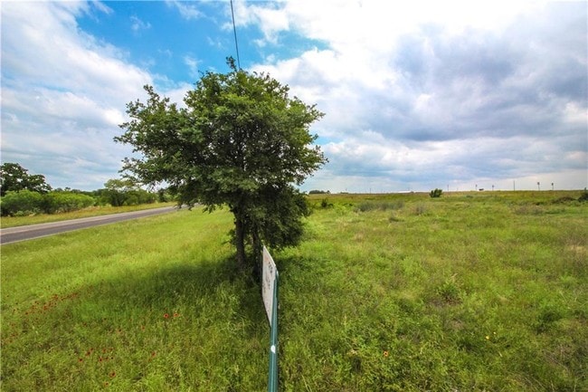
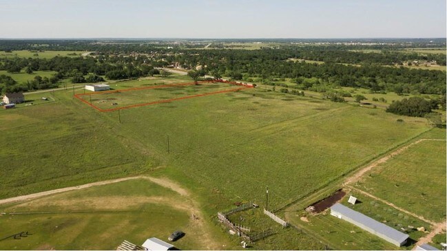
Property Record
636 Sh 304, Bastrop, TX 78602

Property Detail
636 Sh 304
Austin-Round Rock-San Marcos, TX
S5453 - CEDAR CREEK BEND PHASE THREE, LOT 5, ACRES 4
95355
BASTROP
Commercialnec
Texas
B and X Area of moderate flood hazard, usually the area between the limits of the 100-year and 500-year floods.
5
2024
4 AC
2025
Bastrop County
950401
Austin
3,280 SF
NEARBY LISTINGS FOR SALE OR LEASE
DEMOGRAPHICS near 636 Sh 304
1 mile
3 mile
5 mile
2025 Total Population
474
8,811
25,092
2030 Population
530
10,124
28,955
Pop Growth 2025-2030
+ 11.81%
+ 14.90%
+ 15.40%
Average Age
39
39
41
2025 Total Households
169
3,400
9,686
HH Growth 2025-2030
+ 12.43%
+ 15.59%
+ 15.95%
Median Household Inc
$141,176
$77,521
$82,235
Avg Household Size
2.80
2.50
2.50
2025 Avg HH Vehicles
1.00
2.00
2.00
Median Home Value
$644,230
$347,673
$365,619
Median Year Built
1989
2006
2004
Nearby Places
Map Layers
Map Styles
 Street
 Aerial
Layers
 Traffic
 Biking
Places
Listings with unknown addresses are not visible on the map
- Restaurants
- Banks
- Shops
- Fitness
- Groceries
PUBLIC TRANSPORTATION
AIRPORT
Austin-Bergstrom International
Drive
Walk
Distance
Austin-Bergstrom International
39 min
27.0 mi
Freight Ports
Calhoun Port
Drive
Walk
Distance
Calhoun Port
163 min
138.6 mi
SALE & LEASE HISTORY
LISTING DATE
SALE/LEASE

May 10, 2019
For Sale
Nearby Properties
Address
Land Use
TOTAL SIZE
Lot Size
Zoning
Address
Land Use
TOTAL SIZE
Lot Size
Zoning
120,000 SF
12.54 AC
Address
Land Use
TOTAL SIZE
Lot Size
Zoning
38,112 SF
24.16 AC
Address
Land Use
TOTAL SIZE
Lot Size
Zoning
25.59 AC
Address
Land Use
TOTAL SIZE
Lot Size
Zoning
123,176 SF
29.42 AC
Address
Land Use
TOTAL SIZE
Lot Size
Zoning
83,994 SF
7.83 AC
Address
Land Use
TOTAL SIZE
Lot Size
Zoning
125,000 SF
11.98 AC
Address
Land Use
TOTAL SIZE
Lot Size
Zoning
87,953 SF
8.06 AC
Address
Land Use
TOTAL SIZE
Lot Size
Zoning
86,427 SF
23.38 AC
Address
Land Use
TOTAL SIZE
Lot Size
Zoning
49,508 SF
6.58 AC
Address
Land Use
TOTAL SIZE
Lot Size
Zoning
169,350 SF
25.30 AC
Address
Land Use
TOTAL SIZE
Lot Size
Zoning
121,305 SF
16.06 AC
Address
Land Use
TOTAL SIZE
Lot Size
Zoning
24,788 SF
Address
Land Use
TOTAL SIZE
Lot Size
Zoning
59,941 SF
4.57 AC
Address
Land Use
TOTAL SIZE
Lot Size
Zoning
40,261 SF
15 AC
Address
Land Use
TOTAL SIZE
Lot Size
Zoning
133,292 SF
2.67 AC
Address
Land Use
TOTAL SIZE
Lot Size
Zoning
69,508 SF
4.10 AC
Address
Land Use
TOTAL SIZE
Lot Size
Zoning
125,948 SF
12.76 AC
Address
Land Use
TOTAL SIZE
Lot Size
Zoning
54,856 SF
4.15 AC
Address
Land Use
TOTAL SIZE
Lot Size
Zoning
67,979 SF
4.08 AC
Address
Land Use
TOTAL SIZE
Lot Size
Zoning
47,126 SF
3.33 AC
Address
Land Use
TOTAL SIZE
Lot Size
Zoning
32,828 SF
4.02 AC
Address
Land Use
TOTAL SIZE
Lot Size
Zoning
97,631 SF
14.03 AC
Address
Land Use
TOTAL SIZE
Lot Size
Zoning
17,882 SF
3.85 AC
Address
Land Use
TOTAL SIZE
Lot Size
Zoning
71,848 SF
7.27 AC
Address
Land Use
TOTAL SIZE
Lot Size
Zoning
28,080 SF
2.82 AC
Address
Land Use
TOTAL SIZE
Lot Size
Zoning
28.45 AC
Address
Land Use
TOTAL SIZE
Lot Size
Zoning
34,009 SF
8.02 AC
Address
Land Use
TOTAL SIZE
Lot Size
Zoning
1,680 SF
43.63 AC
Address
Land Use
TOTAL SIZE
Lot Size
Zoning
31,002 SF
1.56 AC
Address
Land Use
TOTAL SIZE
Lot Size
Zoning
38,351 SF
3.22 AC
The World's #1 Commercial Real Estate Marketplace
Connect with us
© 2026 CoStar Group
The information above has been obtained from sources believed reliable. While we do not doubt its accuracy we have not verified it and make no guarantee, warranty or representation about it. It is your responsibility to independently confirm its accuracy and completeness. Any projections, opinions, assumptions, or estimates used are for example only and do not represent the current or future performance of the property. The value of this transaction to you depends on tax and other factors which should be evaluated by your tax, financial, and legal advisors. You and your advisors should conduct a careful, independent investigation of the property to determine to your satisfaction the suitability of the property for your needs.