Property Record
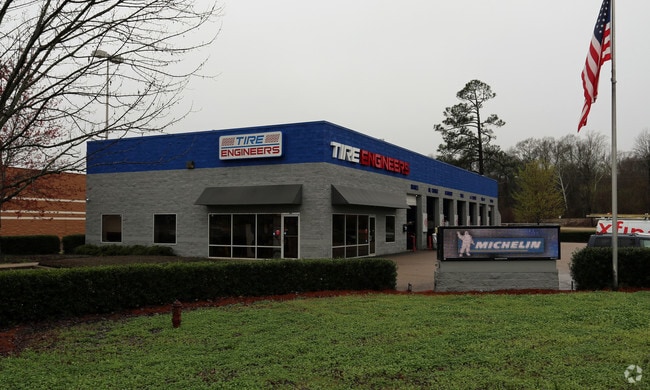
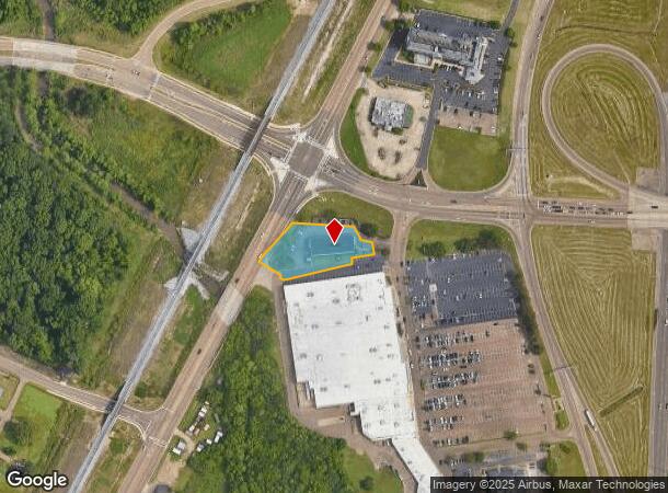
6369 W County Line Rd, Jackson, MS 39209

Property Detail
6369 W County Line Rd
0710-0001-002
BEG INT E/L STATE ST & S/L COUNTY LINE RD E 166.83 FT SELY 153.69 FT SWLY 68.1 FT SLY 19 FT SWLY 221.33 FT NWLY 62.16 FT NELY ALG STATE ST 155.13 FT TO POB IN NW 1/4 NE 1/4 SEC 1 T6 R1E
Autorepair
HINDS
B and X Area of moderate flood hazard, usually the area between the limits of the 100-year and 500-year floods.
Mississippi
2024
0.87 AC
2025
North Jackson
000700
Jackson
6,600 SF
Jackson, MS
NEARBY LISTINGS FOR SALE OR LEASE
DEMOGRAPHICS near 6369 W County Line Rd
1 mile
3 mile
5 mile
2025 Total Population
2,773
50,080
88,654
2030 Population
2,695
49,381
87,708
Pop Growth 2025-2030
(2.81%)
(1.40%)
(1.07%)
Average Age
35
39
40
2025 Total Households
1,085
21,795
38,183
HH Growth 2025-2030
(3.41%)
(1.45%)
(1.13%)
Median Household Inc
$49,047
$59,044
$60,501
Avg Household Size
2.30
2.20
2.20
2025 Avg HH Vehicles
2.00
2.00
2.00
Median Home Value
$146,577
$201,444
$240,170
Median Year Built
1979
1980
1978
Nearby Places
Map Layers
Map Styles
 Street
 Aerial
Transit
 Traffic
 Biking
Places
Listings with unknown addresses are not visible on the map
- Restaurants
- Banks
- Shops
- Fitness
- Groceries
PUBLIC TRANSPORTATION
COMMUTER RAIL
Jackson (City of New Orleans - Amtrak)
Drive
Walk
Distance
Jackson (City of New Orleans - Amtrak)
12 min
8.0 mi
AIRPORT
Jackson-Medgar Wiley Evers International
Drive
Walk
Distance
Jackson-Medgar Wiley Evers International
24 min
14.6 mi
Freight Ports
Port of Greater Baton Rouge
Drive
Walk
Distance
Port of Greater Baton Rouge
206 min
184.6 mi
Nearby Properties
Address
Land Use
TOTAL SIZE
Lot Size
Zoning
Address
Land Use
TOTAL SIZE
Lot Size
Zoning
8,901 SF
37.80 AC
Address
Land Use
TOTAL SIZE
Lot Size
Zoning
326,732 SF
2 AC
Address
Land Use
TOTAL SIZE
Lot Size
Zoning
416,776 SF
18.77 AC
Address
Land Use
TOTAL SIZE
Lot Size
Zoning
297,150 SF
5.70 AC
Address
Land Use
TOTAL SIZE
Lot Size
Zoning
10,904 SF
8.50 AC
Address
Land Use
TOTAL SIZE
Lot Size
Zoning
2,261 SF
15 AC
Address
Land Use
TOTAL SIZE
Lot Size
Zoning
168,084 SF
29.59 AC
Address
Land Use
TOTAL SIZE
Lot Size
Zoning
105,600 SF
13 AC
Address
Land Use
TOTAL SIZE
Lot Size
Zoning
2,986 SF
20.40 AC
Address
Land Use
TOTAL SIZE
Lot Size
Zoning
186,992 SF
27.27 AC
Address
Land Use
TOTAL SIZE
Lot Size
Zoning
54,291 SF
6.99 AC
Address
Land Use
TOTAL SIZE
Lot Size
Zoning
49,949 SF
10 AC
Address
Land Use
TOTAL SIZE
Lot Size
Zoning
57,234 SF
Address
Land Use
TOTAL SIZE
Lot Size
Zoning
102,249 SF
14.38 AC
Address
Land Use
TOTAL SIZE
Lot Size
Zoning
10,866 SF
14.20 AC
Address
Land Use
TOTAL SIZE
Lot Size
Zoning
3,975 SF
6.38 AC
Address
Land Use
TOTAL SIZE
Lot Size
Zoning
10,620 SF
2.81 AC
Address
Land Use
TOTAL SIZE
Lot Size
Zoning
156,184 SF
16.82 AC
Address
Land Use
TOTAL SIZE
Lot Size
Zoning
108,198 SF
15.40 AC
Address
Land Use
TOTAL SIZE
Lot Size
Zoning
310,650 SF
17 AC
Address
Land Use
TOTAL SIZE
Lot Size
Zoning
21,892 SF
9.52 AC
Address
Land Use
TOTAL SIZE
Lot Size
Zoning
107,871 SF
3 AC
Address
Land Use
TOTAL SIZE
Lot Size
Zoning
6,536 SF
9.95 AC
Address
Land Use
TOTAL SIZE
Lot Size
Zoning
48,847 SF
20.70 AC
Address
Land Use
TOTAL SIZE
Lot Size
Zoning
3,369 SF
9 AC
Address
Land Use
TOTAL SIZE
Lot Size
Zoning
6,130 SF
16.93 AC
Address
Land Use
TOTAL SIZE
Lot Size
Zoning
10,310 SF
15 AC
Address
Land Use
TOTAL SIZE
Lot Size
Zoning
3,139 SF
13.20 AC
Address
Land Use
TOTAL SIZE
Lot Size
Zoning
15,865 SF
11.83 AC
Address
Land Use
TOTAL SIZE
Lot Size
Zoning
81,911 SF
15.53 AC
The World's #1 Commercial Real Estate Marketplace
Connect with us
© 2026 CoStar Group
The information above has been obtained from sources believed reliable. While we do not doubt its accuracy we have not verified it and make no guarantee, warranty or representation about it. It is your responsibility to independently confirm its accuracy and completeness. Any projections, opinions, assumptions, or estimates used are for example only and do not represent the current or future performance of the property. The value of this transaction to you depends on tax and other factors which should be evaluated by your tax, financial, and legal advisors. You and your advisors should conduct a careful, independent investigation of the property to determine to your satisfaction the suitability of the property for your needs.