Property Record
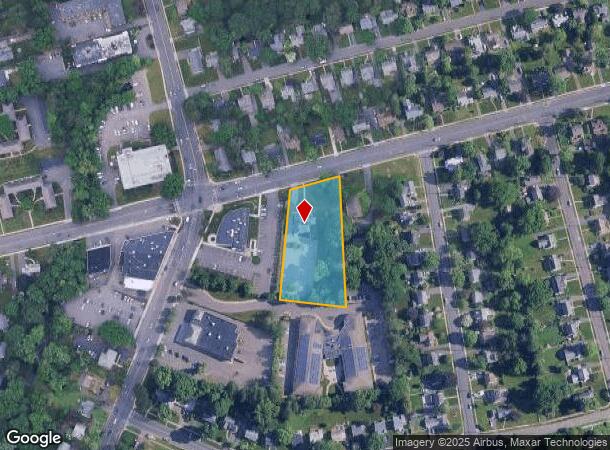
639 Park Rd, West Hartford, CT 06107
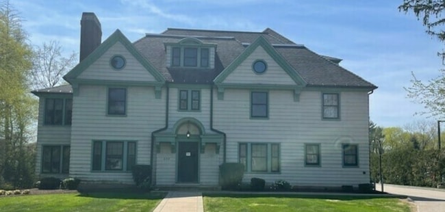

This Property Is For Sale
NEARBY LISTINGS FOR SALE OR LEASE
Property Detail
639 Park Rd
WHAR-000010F-004131-000639
Hartford
Commercialbuilding
Connecticut
X
639
09003C0363F
1.36 AC
2025
West Hartford
2025
Hartford
496300
Hartford-West Hartford-East Hartford, CT
7,545 SF
DEMOGRAPHICS near 639 Park Rd
1 Mile
3 Mile
5 Mile
2024 Total Population
15,414
117,737
243,330
2029 Population
15,261
117,042
242,070
Pop Growth 2024-2029
(0.99%)
(0.59%)
(0.52%)
Average Age
40
40
39
2024 Total Households
6,598
48,347
96,763
HH Growth 2024-2029
(1.08%)
(0.59%)
(0.43%)
Median Household Inc
$112,857
$70,086
$64,960
Avg Household Size
2.30
2.30
2.30
2024 Avg HH Vehicles
2.00
1.00
1.00
Median Home Value
$353,682
$319,711
$273,846
Median Year Built
1948
1953
1956
Nearby Places
Map Layers
Map Styles
 Street
 Aerial
- Restaurants
- Banks
- Shops
- Fitness
- Groceries
PUBLIC TRANSPORTATION
COMMUTER RAIL
DRIVE
WALK
Distance
8 min
4.0 mi
DRIVE
WALK
Distance
8 min
4.0 mi
AIRPORT
Bradley International
DRIVE
WALK
Distance
Bradley International
39 min
21.8 mi
Tweed/New Haven
DRIVE
WALK
Distance
Tweed/New Haven
56 min
41.0 mi
Freight Ports
Port of New Haven
DRIVE
WALK
Distance
Port of New Haven
52 min
38.7 mi
Nearby Properties
Address
Land Use
TOTAL SIZE
Lot Size
Zoning
Address
Land Use
TOTAL SIZE
Lot Size
Zoning
88.48 AC
R-10
Address
Land Use
TOTAL SIZE
Lot Size
Zoning
15.73 AC
CAMP
Address
Land Use
TOTAL SIZE
Lot Size
Zoning
1.45 AC
CAMP
Address
Land Use
TOTAL SIZE
Lot Size
Zoning
29.35 AC
CAMP
Address
Land Use
TOTAL SIZE
Lot Size
Zoning
3,605 SF
28.33 AC
R-6,RM
Address
Land Use
TOTAL SIZE
Lot Size
Zoning
20.61 AC
R-10,S
Address
Land Use
TOTAL SIZE
Lot Size
Zoning
416,762 SF
20 AC
CAMP
Address
Land Use
TOTAL SIZE
Lot Size
Zoning
20.41 AC
MX-2
Address
Land Use
TOTAL SIZE
Lot Size
Zoning
197,704 SF
1.82 AC
CAMP
Address
Land Use
TOTAL SIZE
Lot Size
Zoning
211,308 SF
55.90 AC
R-13
Address
Land Use
TOTAL SIZE
Lot Size
Zoning
9,238 SF
28.35 AC
R-10,R
Address
Land Use
TOTAL SIZE
Lot Size
Zoning
112,975 SF
11.44 AC
RM-3
Address
Land Use
TOTAL SIZE
Lot Size
Zoning
223,885 SF
43.33 AC
CAMP
Address
Land Use
TOTAL SIZE
Lot Size
Zoning
3.41 AC
BC,RP
Address
Land Use
TOTAL SIZE
Lot Size
Zoning
86,600 SF
20.05 AC
R-6
Address
Land Use
TOTAL SIZE
Lot Size
Zoning
15.39 AC
SDD/RM
Address
Land Use
TOTAL SIZE
Lot Size
Zoning
19.66 AC
CAMP
Address
Land Use
TOTAL SIZE
Lot Size
Zoning
16.94 AC
C1
Address
Land Use
TOTAL SIZE
Lot Size
Zoning
215,215 SF
42 AC
R-10,R
Address
Land Use
TOTAL SIZE
Lot Size
Zoning
2.32 AC
SDD/CB
Address
Land Use
TOTAL SIZE
Lot Size
Zoning
215,883 SF
10.02 AC
MX-2
Address
Land Use
TOTAL SIZE
Lot Size
Zoning
8.17 AC
BS,R-1
Address
Land Use
TOTAL SIZE
Lot Size
Zoning
2.84 AC
CBDH
Address
Land Use
TOTAL SIZE
Lot Size
Zoning
8.87 AC
BS,R-1
Address
Land Use
TOTAL SIZE
Lot Size
Zoning
6.34 AC
BS,R-1
Address
Land Use
TOTAL SIZE
Lot Size
Zoning
13.13 AC
SDD/BG
Address
Land Use
TOTAL SIZE
Lot Size
Zoning
638,979 SF
3.24 AC
MX-2
Address
Land Use
TOTAL SIZE
Lot Size
Zoning
215,058 SF
R-6
Address
Land Use
TOTAL SIZE
Lot Size
Zoning
Address
Land Use
TOTAL SIZE
Lot Size
Zoning
3.21 AC
MX-2
The World's #1 Commercial Real Estate Marketplace
Connect with us
© 2026 CoStar Group
The information above has been obtained from sources believed reliable. While we do not doubt its accuracy we have not verified it and make no guarantee, warranty or representation about it. It is your responsibility to independently confirm its accuracy and completeness. Any projections, opinions, assumptions, or estimates used are for example only and do not represent the current or future performance of the property. The value of this transaction to you depends on tax and other factors which should be evaluated by your tax, financial, and legal advisors. You and your advisors should conduct a careful, independent investigation of the property to determine to your satisfaction the suitability of the property for your needs.