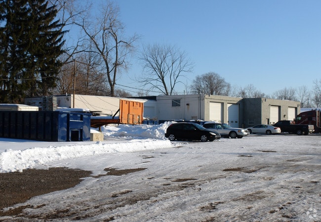
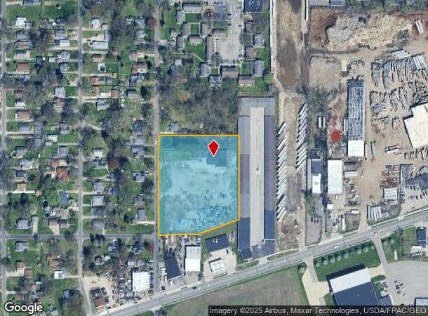
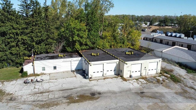
Property Record
637 Elmdale Rd, Toledo, OH 43609
NEARBY LISTINGS FOR SALE OR LEASE
Property Detail
637 Elmdale Rd
20-00401
3 8 SE 1/4 W 335 FT PT N TOLEDO WAUSEONRD & S OF N 890 FT E
Warehouse
Lucas
X
Ohio
39095C0088F
3.05 AC
0
South/Southwest
2025
Toledo
006801
Toledo, OH
7,298 SF
DEMOGRAPHICS near 637 Elmdale Rd
1 Mile
3 Mile
5 Mile
2024 Total Population
7,172
84,117
217,575
2029 Population
7,158
83,210
215,980
Pop Growth 2024-2029
(0.20%)
(1.08%)
(0.73%)
Average Age
34
38
39
2024 Total Households
3,465
35,909
95,713
HH Growth 2024-2029
+ 0.14%
(1.13%)
(0.77%)
Median Household Inc
$31,777
$43,234
$48,004
Avg Household Size
2.00
2.20
2.10
2024 Avg HH Vehicles
1.00
2.00
2.00
Median Home Value
$66,820
$107,051
$126,945
Median Year Built
1973
1958
1959
Nearby Places
Map Layers
Map Styles
 Street
 Aerial
- Restaurants
- Banks
- Shops
- Fitness
- Groceries
PUBLIC TRANSPORTATION
COMMUTER RAIL
DRIVE
WALK
Distance
8 min
4.2 mi
AIRPORT
Eugene F Kranz Toledo Express
DRIVE
WALK
Distance
Eugene F Kranz Toledo Express
29 min
14.9 mi
Freight Ports
DRIVE
WALK
Distance
21 min
10.3 mi
SALE & LEASE HISTORY
LISTING DATE
SALE/LEASE

Jun 16, 2025
For Sale
Nearby Properties
Address
Land Use
TOTAL SIZE
Lot Size
Zoning
Address
Land Use
TOTAL SIZE
Lot Size
Zoning
3,076,310 SF
127.88 AC
10-MX
Address
Land Use
TOTAL SIZE
Lot Size
Zoning
1,237,446 SF
193.94 AC
10-RS12
Address
Land Use
TOTAL SIZE
Lot Size
Zoning
513,157 SF
39.38 AC
10-MX
Address
Land Use
TOTAL SIZE
Lot Size
Zoning
323,421 SF
134.98 AC
10-IC
Address
Land Use
TOTAL SIZE
Lot Size
Zoning
202,563 SF
6.19 AC
10-IG
Address
Land Use
TOTAL SIZE
Lot Size
Zoning
245,237 SF
31.72 AC
10-MX
Address
Land Use
TOTAL SIZE
Lot Size
Zoning
436,094 SF
30.06 AC
10-RS6
Address
Land Use
TOTAL SIZE
Lot Size
Zoning
11.16 AC
10-RM24
Address
Land Use
TOTAL SIZE
Lot Size
Zoning
393,343 SF
62.48 AC
10-IC
Address
Land Use
TOTAL SIZE
Lot Size
Zoning
148,842 SF
9.84 AC
10-IL
Address
Land Use
TOTAL SIZE
Lot Size
Zoning
246,438 SF
8.22 AC
10-RM36
Address
Land Use
TOTAL SIZE
Lot Size
Zoning
173,943 SF
59.70 AC
10-IP
Address
Land Use
TOTAL SIZE
Lot Size
Zoning
123,064 SF
10 AC
10-RS6
Address
Land Use
TOTAL SIZE
Lot Size
Zoning
170,960 SF
4 AC
10-RS6
Address
Land Use
TOTAL SIZE
Lot Size
Zoning
275,113 SF
21 AC
10-MX
Address
Land Use
TOTAL SIZE
Lot Size
Zoning
90,340 SF
2.18 AC
10-IL
Address
Land Use
TOTAL SIZE
Lot Size
Zoning
94,439 SF
9 AC
10-CO
Address
Land Use
TOTAL SIZE
Lot Size
Zoning
316,351 SF
30.65 AC
10-IC
Address
Land Use
TOTAL SIZE
Lot Size
Zoning
138,607 SF
21.30 AC
10-RS12
Address
Land Use
TOTAL SIZE
Lot Size
Zoning
94,891 SF
18.80 AC
10-RS6
Address
Land Use
TOTAL SIZE
Lot Size
Zoning
59 AC
10-IP
Address
Land Use
TOTAL SIZE
Lot Size
Zoning
81,672 SF
14.93 AC
10-RS9
Address
Land Use
TOTAL SIZE
Lot Size
Zoning
122,277 SF
7 AC
10-IL
Address
Land Use
TOTAL SIZE
Lot Size
Zoning
210,996 SF
22.18 AC
10-CRSO
Address
Land Use
TOTAL SIZE
Lot Size
Zoning
166,583 SF
9.75 AC
10-RS9
Address
Land Use
TOTAL SIZE
Lot Size
Zoning
172,739 SF
10.93 AC
10-IL
Address
Land Use
TOTAL SIZE
Lot Size
Zoning
131,201 SF
10 AC
10-CUP
Address
Land Use
TOTAL SIZE
Lot Size
Zoning
102,516 SF
0.85 AC
10-CR
Address
Land Use
TOTAL SIZE
Lot Size
Zoning
196,015 SF
6 AC
10-RM36
Address
Land Use
TOTAL SIZE
Lot Size
Zoning
363,176 SF
11.72 AC
10-RM36
The World's #1 Commercial Real Estate Marketplace
Connect with us
© 2026 CoStar Group
The information above has been obtained from sources believed reliable. While we do not doubt its accuracy we have not verified it and make no guarantee, warranty or representation about it. It is your responsibility to independently confirm its accuracy and completeness. Any projections, opinions, assumptions, or estimates used are for example only and do not represent the current or future performance of the property. The value of this transaction to you depends on tax and other factors which should be evaluated by your tax, financial, and legal advisors. You and your advisors should conduct a careful, independent investigation of the property to determine to your satisfaction the suitability of the property for your needs.