Property Record
637 Main St, Somers, CT 06071


Save to a Folder
{{folder.Name}}
{{folder.ListingIds.length}} Properties
{{folder.ListingIds.length}} Property
Create a New Folder
Property Detail
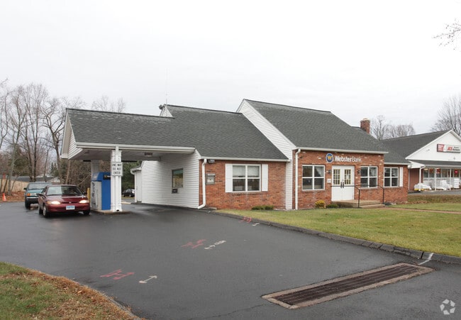
637 Main St
Financialbuilding
Capitol
B
Connecticut
B and X Area of moderate flood hazard, usually the area between the limits of the 100-year and 500-year floods.
0.50 AC
2025
Tolland County
2025
Hartford
538202
Hartford-West Hartford-East Hartford, CT
1,594 SF
SOME-000030-000000-000005A
NEARBY LISTINGS FOR SALE OR LEASE
DEMOGRAPHICS near 637 Main St
1 mile
3 mile
5 mile
2025 Total Population
2,191
8,706
25,913
2030 Population
2,241
8,906
26,487
Pop Growth 2025-2030
+ 2.28%
+ 2.30%
+ 2.22%
Average Age
45
44
44
2025 Total Households
888
3,369
9,515
HH Growth 2025-2030
+ 2.14%
+ 2.29%
+ 2.23%
Median Household Inc
$102,734
$112,063
$115,433
Avg Household Size
2.50
2.50
2.50
2025 Avg HH Vehicles
2.00
2.00
2.00
Median Home Value
$414,449
$393,079
$355,720
Median Year Built
1979
1975
1973
Nearby Places
Map Layers
Map Styles
 Street
 Aerial
Layers
 Traffic
 Biking
Places
Listings with unknown addresses are not visible on the map
- Restaurants
- Banks
- Shops
- Fitness
- Groceries
PUBLIC TRANSPORTATION
AIRPORT
Bradley International
Drive
Walk
Distance
Bradley International
32 min
15.7 mi
Worcester Regional
Drive
Walk
Distance
Worcester Regional
73 min
47.5 mi
Freight Ports
Port of New Haven
Drive
Walk
Distance
Port of New Haven
81 min
60.3 mi
Nearby Properties
Address
Land Use
TOTAL SIZE
Lot Size
Zoning
Address
Land Use
TOTAL SIZE
Lot Size
Zoning
108.50 AC
A-1
Address
Land Use
TOTAL SIZE
Lot Size
Zoning
55.75 AC
AAA
Address
Land Use
TOTAL SIZE
Lot Size
Zoning
78,835 SF
5.94 AC
Address
Land Use
TOTAL SIZE
Lot Size
Zoning
152.20 AC
A-1
Address
Land Use
TOTAL SIZE
Lot Size
Zoning
20.56 AC
MF
Address
Land Use
TOTAL SIZE
Lot Size
Zoning
2.20 AC
A-1
Address
Land Use
TOTAL SIZE
Lot Size
Zoning
8.10 AC
B
Address
Land Use
TOTAL SIZE
Lot Size
Zoning
16,282 SF
11 AC
A-1
Address
Land Use
TOTAL SIZE
Lot Size
Zoning
18.66 AC
Address
Land Use
TOTAL SIZE
Lot Size
Zoning
20,208 SF
2 AC
A-1
Address
Land Use
TOTAL SIZE
Lot Size
Zoning
9.76 AC
MF
Address
Land Use
TOTAL SIZE
Lot Size
Zoning
37,656 SF
10.42 AC
A-1
Address
Land Use
TOTAL SIZE
Lot Size
Zoning
10.11 AC
A-1
Address
Land Use
TOTAL SIZE
Lot Size
Zoning
16,884 SF
5.50 AC
B
Address
Land Use
TOTAL SIZE
Lot Size
Zoning
123.07 AC
A-1
Address
Land Use
TOTAL SIZE
Lot Size
Zoning
48,360 SF
7.74 AC
I
Address
Land Use
TOTAL SIZE
Lot Size
Zoning
76 AC
A-1
Address
Land Use
TOTAL SIZE
Lot Size
Zoning
48,360 SF
6.04 AC
I
Address
Land Use
TOTAL SIZE
Lot Size
Zoning
30,601 SF
12.98 AC
I
Address
Land Use
TOTAL SIZE
Lot Size
Zoning
105.61 AC
A-1
Address
Land Use
TOTAL SIZE
Lot Size
Zoning
6,973 SF
2.85 AC
B
Address
Land Use
TOTAL SIZE
Lot Size
Zoning
3.17 AC
Address
Land Use
TOTAL SIZE
Lot Size
Zoning
21.99 AC
A-1
Address
Land Use
TOTAL SIZE
Lot Size
Zoning
3,000 SF
34.43 AC
RAR
Address
Land Use
TOTAL SIZE
Lot Size
Zoning
3.44 AC
I
Address
Land Use
TOTAL SIZE
Lot Size
Zoning
1.63 AC
B
Address
Land Use
TOTAL SIZE
Lot Size
Zoning
13,185 SF
3.50 AC
A-1
Address
Land Use
TOTAL SIZE
Lot Size
Zoning
1.84 AC
A-1
Address
Land Use
TOTAL SIZE
Lot Size
Zoning
40.29 AC
A-1
Address
Land Use
TOTAL SIZE
Lot Size
Zoning
10,374 SF
8 AC
I
The World's #1 Commercial Real Estate Marketplace
Connect with us
© 2026 CoStar Group
The information above has been obtained from sources believed reliable. While we do not doubt its accuracy we have not verified it and make no guarantee, warranty or representation about it. It is your responsibility to independently confirm its accuracy and completeness. Any projections, opinions, assumptions, or estimates used are for example only and do not represent the current or future performance of the property. The value of this transaction to you depends on tax and other factors which should be evaluated by your tax, financial, and legal advisors. You and your advisors should conduct a careful, independent investigation of the property to determine to your satisfaction the suitability of the property for your needs.