Property Record
6370 Parkton Rd, Parkton, NC 28371
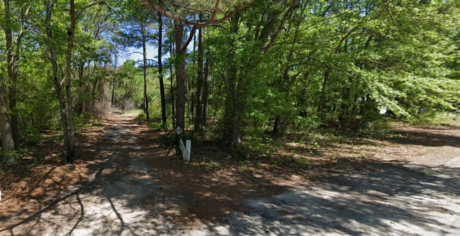

This Property Is For Sale
NEARBY LISTINGS FOR SALE OR LEASE
-
-
No Photo
-
-
-
-
View all Parkton listings for sale on LoopNet.com
Property Detail
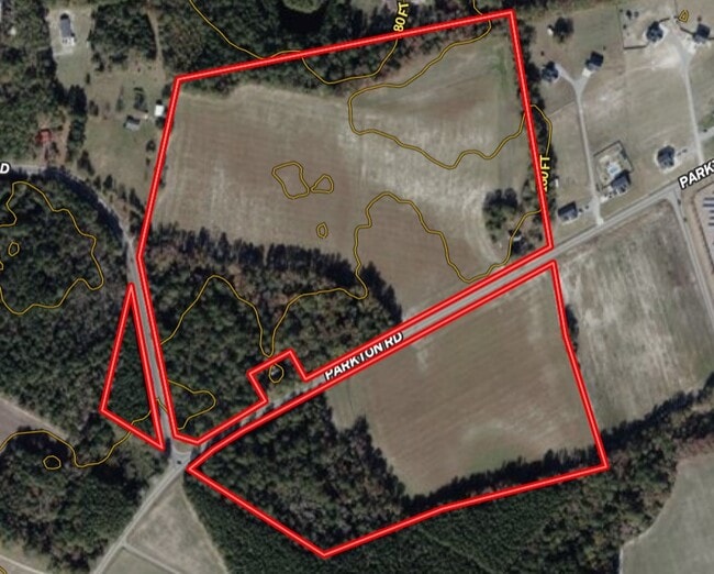
6370 Parkton Rd
Fayetteville, NC
Grays Creek District
0403-91-6444
Cumberland
Ruralagriculturalresidence
North Carolina
X
68 AC
3720041300J
Southwest Fayetteville
962 SF
Fayetteville
DEMOGRAPHICS near 6370 Parkton Rd
1 Mile
3 Mile
5 Mile
2024 Total Population
1,551
19,670
56,748
2029 Population
1,541
19,447
56,467
Pop Growth 2024-2029
(0.64%)
(1.13%)
(0.50%)
Average Age
36
36
35
2024 Total Households
550
7,114
20,246
HH Growth 2024-2029
(0.73%)
(1.17%)
(0.51%)
Median Household Inc
$56,188
$57,185
$63,987
Avg Household Size
2.80
2.70
2.80
2024 Avg HH Vehicles
2.00
2.00
2.00
Median Home Value
$168,965
$166,799
$175,439
Median Year Built
1992
1991
1993
Nearby Places
Map Layers
Map Styles
 Street
 Aerial
- Restaurants
- Banks
- Shops
- Fitness
- Groceries
PUBLIC TRANSPORTATION
AIRPORT
Fayetteville Regional/Grannis Field
DRIVE
WALK
Distance
Fayetteville Regional/Grannis Field
13 min
8.5 mi
Freight Ports
Port of Wilmington
DRIVE
WALK
Distance
Port of Wilmington
124 min
88.3 mi
Nearby Properties
Address
Land Use
TOTAL SIZE
Lot Size
Zoning
Address
Land Use
TOTAL SIZE
Lot Size
Zoning
7,418 SF
10 AC
OIP
Address
Land Use
TOTAL SIZE
Lot Size
Zoning
2,476 SF
7.36 AC
R5A
Address
Land Use
TOTAL SIZE
Lot Size
Zoning
531.87 AC
A1
Address
Land Use
TOTAL SIZE
Lot Size
Zoning
51,180 SF
26 AC
R6
Address
Land Use
TOTAL SIZE
Lot Size
Zoning
3,236 SF
16.32 AC
R6
Address
Land Use
TOTAL SIZE
Lot Size
Zoning
19,420 SF
14.04 AC
PND
Address
Land Use
TOTAL SIZE
Lot Size
Zoning
2,499 SF
5.15 AC
R10
Address
Land Use
TOTAL SIZE
Lot Size
Zoning
49,085 SF
16.55 AC
R10
Address
Land Use
TOTAL SIZE
Lot Size
Zoning
7,246 SF
10.01 AC
RRCZ-RURAL
Address
Land Use
TOTAL SIZE
Lot Size
Zoning
5,666 SF
5.09 AC
R6
Address
Land Use
TOTAL SIZE
Lot Size
Zoning
377 SF
6.51 AC
R5
Address
Land Use
TOTAL SIZE
Lot Size
Zoning
10.59 AC
CP-PLANNED
Address
Land Use
TOTAL SIZE
Lot Size
Zoning
10,200 SF
14.37 AC
C3
Address
Land Use
TOTAL SIZE
Lot Size
Zoning
14,100 SF
9.05 AC
CP
Address
Land Use
TOTAL SIZE
Lot Size
Zoning
1,726 SF
6.08 AC
R6
Address
Land Use
TOTAL SIZE
Lot Size
Zoning
3,066 SF
9.36 AC
R6
Address
Land Use
TOTAL SIZE
Lot Size
Zoning
17,967 SF
28.51 AC
R10
Address
Land Use
TOTAL SIZE
Lot Size
Zoning
1.33 AC
C1P
Address
Land Use
TOTAL SIZE
Lot Size
Zoning
6,000 SF
5.54 AC
CP-PLANNED
Address
Land Use
TOTAL SIZE
Lot Size
Zoning
82.81 AC
CP-PLANNED
Address
Land Use
TOTAL SIZE
Lot Size
Zoning
8.37 AC
CP-PLANNED
Address
Land Use
TOTAL SIZE
Lot Size
Zoning
49.90 AC
CP-PLANNED
Address
Land Use
TOTAL SIZE
Lot Size
Zoning
11.17 AC
C3
Address
Land Use
TOTAL SIZE
Lot Size
Zoning
34.23 AC
CP
Address
Land Use
TOTAL SIZE
Lot Size
Zoning
3,212 SF
4.31 AC
CP-PLANNED
Address
Land Use
TOTAL SIZE
Lot Size
Zoning
9,280 SF
12.46 AC
RR
Address
Land Use
TOTAL SIZE
Lot Size
Zoning
10,200 SF
5.80 AC
CP
Address
Land Use
TOTAL SIZE
Lot Size
Zoning
20,400 SF
34.39 AC
CP
Address
Land Use
TOTAL SIZE
Lot Size
Zoning
2,122 SF
0.26 AC
R6
Address
Land Use
TOTAL SIZE
Lot Size
Zoning
2,122 SF
0.26 AC
R6
The World's #1 Commercial Real Estate Marketplace
Connect with us
© 2026 CoStar Group
The information above has been obtained from sources believed reliable. While we do not doubt its accuracy we have not verified it and make no guarantee, warranty or representation about it. It is your responsibility to independently confirm its accuracy and completeness. Any projections, opinions, assumptions, or estimates used are for example only and do not represent the current or future performance of the property. The value of this transaction to you depends on tax and other factors which should be evaluated by your tax, financial, and legal advisors. You and your advisors should conduct a careful, independent investigation of the property to determine to your satisfaction the suitability of the property for your needs.