Property Record
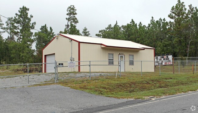
6370 Platt Springs Rd, Lexington, SC 29073


NEARBY LISTINGS FOR SALE OR LEASE
-
-
View all Lexington listings for sale on LoopNet.com
Property Detail
6370 Platt Springs Rd
007500-03-178
Robert G Barger
Commercialnec
Lexington
X
South Carolina
45063C0244J
1.06 AC
2025
Lexington
2024
Columbia
021036
Columbia, SC
1,200 SF
DEMOGRAPHICS near 6370 Platt Springs Rd
1 Mile
3 Mile
5 Mile
2024 Total Population
2,782
20,901
42,568
2029 Population
3,037
23,055
46,745
Pop Growth 2024-2029
+ 9.17%
+ 10.31%
+ 9.81%
Average Age
36
35
37
2024 Total Households
951
7,258
15,219
HH Growth 2024-2029
+ 9.36%
+ 10.48%
+ 10.00%
Median Household Inc
$78,646
$69,113
$68,805
Avg Household Size
2.90
2.80
2.80
2024 Avg HH Vehicles
2.00
2.00
2.00
Median Home Value
$178,370
$191,293
$185,799
Median Year Built
2002
2003
2001
Nearby Places
Map Layers
Map Styles
 Street
 Aerial
- Restaurants
- Banks
- Shops
- Fitness
- Groceries
PUBLIC TRANSPORTATION
AIRPORT
Columbia Metro
DRIVE
WALK
Distance
Columbia Metro
27 min
11.1 mi
Freight Ports
North Charleston Terminal
DRIVE
WALK
Distance
North Charleston Terminal
133 min
113.1 mi
Nearby Properties
Address
Land Use
TOTAL SIZE
Lot Size
Zoning
Address
Land Use
TOTAL SIZE
Lot Size
Zoning
219,967 SF
23.37 AC
ID
Address
Land Use
TOTAL SIZE
Lot Size
Zoning
139,481 SF
15.48 AC
ID
Address
Land Use
TOTAL SIZE
Lot Size
Zoning
54,747 SF
5.70 AC
ID
Address
Land Use
TOTAL SIZE
Lot Size
Zoning
13,640 SF
4 AC
ID
Address
Land Use
TOTAL SIZE
Lot Size
Zoning
21,360 SF
2.82 AC
RD
Address
Land Use
TOTAL SIZE
Lot Size
Zoning
7,227 SF
1.03 AC
RD
Address
Land Use
TOTAL SIZE
Lot Size
Zoning
5,355 SF
4.93 AC
ID
Address
Land Use
TOTAL SIZE
Lot Size
Zoning
10,640 SF
1.47 AC
RD
Address
Land Use
TOTAL SIZE
Lot Size
Zoning
6,226 SF
2.26 AC
RD
Address
Land Use
TOTAL SIZE
Lot Size
Zoning
3,318 SF
0.68 AC
Address
Land Use
TOTAL SIZE
Lot Size
Zoning
12,704 SF
3.60 AC
RD
Address
Land Use
TOTAL SIZE
Lot Size
Zoning
56,023 SF
4.52 AC
ID
Address
Land Use
TOTAL SIZE
Lot Size
Zoning
1,771 SF
6 AC
ID
Address
Land Use
TOTAL SIZE
Lot Size
Zoning
10,080 SF
8 AC
RD
Address
Land Use
TOTAL SIZE
Lot Size
Zoning
3,897 SF
1.60 AC
RD
Address
Land Use
TOTAL SIZE
Lot Size
Zoning
4,680 SF
1.77 AC
RD
Address
Land Use
TOTAL SIZE
Lot Size
Zoning
3,800 SF
14.73 AC
RD
Address
Land Use
TOTAL SIZE
Lot Size
Zoning
2,790 SF
1.52 AC
ID
Address
Land Use
TOTAL SIZE
Lot Size
Zoning
6,480 SF
1.17 AC
RD
Address
Land Use
TOTAL SIZE
Lot Size
Zoning
12,204 SF
1.63 AC
ID
Address
Land Use
TOTAL SIZE
Lot Size
Zoning
5,108 SF
1.21 AC
RD
Address
Land Use
TOTAL SIZE
Lot Size
Zoning
2,526 SF
1.26 AC
RD
Address
Land Use
TOTAL SIZE
Lot Size
Zoning
2,816 SF
25.45 AC
RD
Address
Land Use
TOTAL SIZE
Lot Size
Zoning
1,404 SF
0.51 AC
RD
Address
Land Use
TOTAL SIZE
Lot Size
Zoning
9,100 SF
0.92 AC
ID
Address
Land Use
TOTAL SIZE
Lot Size
Zoning
4,304 SF
8.44 AC
RD
Address
Land Use
TOTAL SIZE
Lot Size
Zoning
5.25 AC
RD
Address
Land Use
TOTAL SIZE
Lot Size
Zoning
99.05 AC
RD
Address
Land Use
TOTAL SIZE
Lot Size
Zoning
2,800 SF
4 AC
ID
Address
Land Use
TOTAL SIZE
Lot Size
Zoning
8,160 SF
5 AC
ID
The World's #1 Commercial Real Estate Marketplace
Connect with us
© 2026 CoStar Group
The information above has been obtained from sources believed reliable. While we do not doubt its accuracy we have not verified it and make no guarantee, warranty or representation about it. It is your responsibility to independently confirm its accuracy and completeness. Any projections, opinions, assumptions, or estimates used are for example only and do not represent the current or future performance of the property. The value of this transaction to you depends on tax and other factors which should be evaluated by your tax, financial, and legal advisors. You and your advisors should conduct a careful, independent investigation of the property to determine to your satisfaction the suitability of the property for your needs.