Property Record
6372 E State Highway 100 E, Palm Coast, FL 32137
NEARBY LISTINGS FOR SALE OR LEASE
Property Detail
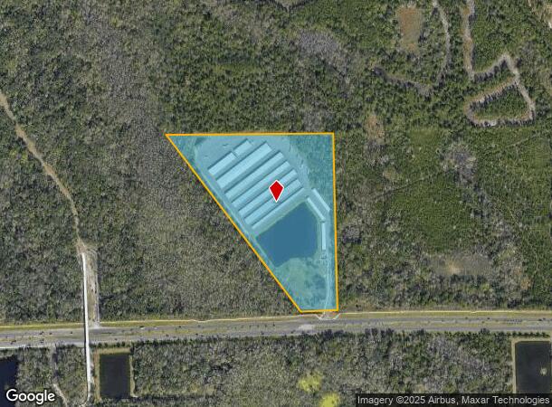
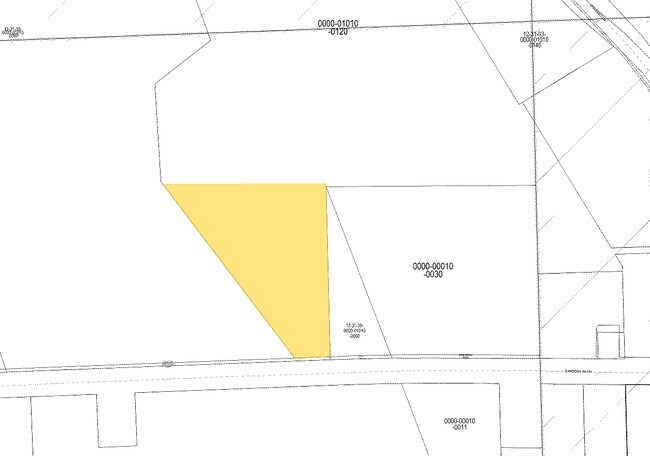
6372 E State Highway 100 E
03-12-31-0000-01010-0120
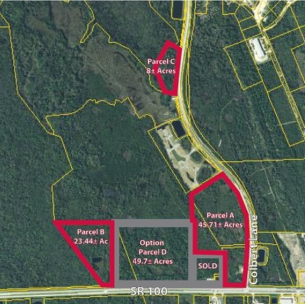
23.52 AC PART OF 3,10,11,39 LYING NORTH OF SR 100, W OF COLBERT PARCEL 50.42 ENTRANCEWAY ON COLBERT & 277.47 ALONG SR 100 MORE PARTICULARLY DESC IN 861/1526 OR 1007 PG 445 (EXC 1.15 AC DEEDED TO FLAGLER LIFESTYLE OR 1190/1606) PC ORD 2005-20 1262/161
Shipyard
Flagler
AE
Florida
12035C0231E
12
2024
23.52 AC
2025
Daytona Area
060107
Other Market Areas
459,150 SF
Deltona-Daytona Beach-Ormond Beach, FL
DEMOGRAPHICS near 6372 E State Highway 100 E
1 Mile
3 Mile
5 Mile
2024 Total Population
0
11,302
50,830
2029 Population
0
13,925
62,339
Pop Growth 2024-2029
0.00%
+ 23.21%
+ 22.64%
Average Age
0
50
48
2024 Total Households
0
5,221
21,291
HH Growth 2024-2029
0.00%
+ 22.51%
+ 21.90%
Median Household Inc
$0
$50,173
$64,353
Avg Household Size
.00
2.10
2.40
2024 Avg HH Vehicles
.00
2.00
2.00
Median Home Value
$0
$354,093
$287,282
Median Year Built
0
1999
2003
Nearby Places
Map Layers
Map Styles
 Street
 Aerial
- Restaurants
- Banks
- Shops
- Fitness
- Groceries
PUBLIC TRANSPORTATION
AIRPORT
Daytona Beach International
DRIVE
WALK
Distance
Daytona Beach International
35 min
25.9 mi
Freight Ports
Jacksonville Port
DRIVE
WALK
Distance
Jacksonville Port
86 min
72.0 mi
SALE & LEASE HISTORY
LISTING DATE
SALE/LEASE

Sep 24, 2016
For Sale
Nearby Properties
Address
Land Use
TOTAL SIZE
Lot Size
Zoning
Address
Land Use
TOTAL SIZE
Lot Size
Zoning
345,915 SF
94.85 AC
COM-2
Address
Land Use
TOTAL SIZE
Lot Size
Zoning
913,614 SF
85.53 AC
PSP
Address
Land Use
TOTAL SIZE
Lot Size
Zoning
142,653 SF
15.71 AC
PUD
Address
Land Use
TOTAL SIZE
Lot Size
Zoning
217,927 SF
1,165.37 AC
I-C
Address
Land Use
TOTAL SIZE
Lot Size
Zoning
225,108 SF
41.71 AC
MPD
Address
Land Use
TOTAL SIZE
Lot Size
Zoning
141,171 SF
8.18 AC
MPD
Address
Land Use
TOTAL SIZE
Lot Size
Zoning
36,125 SF
11.26 AC
Address
Land Use
TOTAL SIZE
Lot Size
Zoning
904.63 AC
PUD
Address
Land Use
TOTAL SIZE
Lot Size
Zoning
124,911 SF
10.18 AC
PUD
Address
Land Use
TOTAL SIZE
Lot Size
Zoning
15.91 AC
PSP
Address
Land Use
TOTAL SIZE
Lot Size
Zoning
553.49 AC
PUD
Address
Land Use
TOTAL SIZE
Lot Size
Zoning
82,459 SF
4.09 AC
MPD
Address
Land Use
TOTAL SIZE
Lot Size
Zoning
122,353 SF
17.97 AC
MPD
Address
Land Use
TOTAL SIZE
Lot Size
Zoning
208,450 SF
11.85 AC
MPD
Address
Land Use
TOTAL SIZE
Lot Size
Zoning
45.82 AC
C-2
Address
Land Use
TOTAL SIZE
Lot Size
Zoning
220.05 AC
MPD
Address
Land Use
TOTAL SIZE
Lot Size
Zoning
42,025 SF
15.64 AC
MPD
Address
Land Use
TOTAL SIZE
Lot Size
Zoning
112,500 SF
5 AC
HC
Address
Land Use
TOTAL SIZE
Lot Size
Zoning
231,560 SF
39.56 AC
I-C
Address
Land Use
TOTAL SIZE
Lot Size
Zoning
84,899 SF
10.35 AC
COM-2
Address
Land Use
TOTAL SIZE
Lot Size
Zoning
35,243 SF
8.45 AC
COM-3
Address
Land Use
TOTAL SIZE
Lot Size
Zoning
28,591 SF
3.84 AC
PUD
Address
Land Use
TOTAL SIZE
Lot Size
Zoning
54,500 SF
4.95 AC
COM-2
Address
Land Use
TOTAL SIZE
Lot Size
Zoning
47,264 SF
10.20 AC
MPD
Address
Land Use
TOTAL SIZE
Lot Size
Zoning
82,427 SF
8.98 AC
HC
Address
Land Use
TOTAL SIZE
Lot Size
Zoning
117.21 AC
AC
Address
Land Use
TOTAL SIZE
Lot Size
Zoning
50,497 SF
9.74 AC
MPD
Address
Land Use
TOTAL SIZE
Lot Size
Zoning
35,065 SF
19.37 AC
PSP
Address
Land Use
TOTAL SIZE
Lot Size
Zoning
27.22 AC
MPD
The World's #1 Commercial Real Estate Marketplace
Connect with us
© 2026 CoStar Group
The information above has been obtained from sources believed reliable. While we do not doubt its accuracy we have not verified it and make no guarantee, warranty or representation about it. It is your responsibility to independently confirm its accuracy and completeness. Any projections, opinions, assumptions, or estimates used are for example only and do not represent the current or future performance of the property. The value of this transaction to you depends on tax and other factors which should be evaluated by your tax, financial, and legal advisors. You and your advisors should conduct a careful, independent investigation of the property to determine to your satisfaction the suitability of the property for your needs.