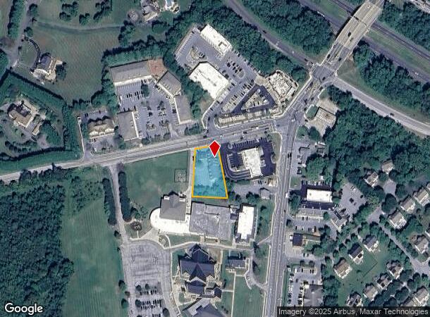
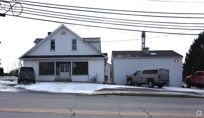
Property Record
6374 Ten Oaks Rd, Clarksville, MD 21029


NEARBY LISTINGS FOR SALE OR LEASE
Property Detail
6374 Ten Oaks Rd
05-348986
.7037 A. 6374 TEN OAKS RD CLARKSVILLE
Storebuilding
Howard
X
Maryland
24027C0130D
0.70 AC
2024
Outlying Howard County
2025
Baltimore
605103
Baltimore-Columbia-Towson, MD
2,360 SF
DEMOGRAPHICS near 6374 Ten Oaks Rd
1 Mile
3 Mile
5 Mile
2024 Total Population
4,691
27,616
84,462
2029 Population
4,778
28,367
86,752
Pop Growth 2024-2029
+ 1.85%
+ 2.72%
+ 2.71%
Average Age
40
41
41
2024 Total Households
1,470
9,326
30,973
HH Growth 2024-2029
+ 1.84%
+ 2.73%
+ 2.84%
Median Household Inc
$221,168
$179,726
$148,125
Avg Household Size
3.20
2.90
2.70
2024 Avg HH Vehicles
3.00
2.00
2.00
Median Home Value
$750,968
$761,236
$660,543
Median Year Built
1999
1991
1987
Nearby Places
Map Layers
Map Styles
 Street
 Aerial
- Restaurants
- Banks
- Shops
- Fitness
- Groceries
PUBLIC TRANSPORTATION
AIRPORT
Baltimore/Washington International Thurgood Marshall
DRIVE
WALK
Distance
Baltimore/Washington International Thurgood Marshall
28 min
20.4 mi
Ronald Reagan Washington Ntl
DRIVE
WALK
Distance
Ronald Reagan Washington Ntl
51 min
31.5 mi
Freight Ports
Port of Baltimore
DRIVE
WALK
Distance
Port of Baltimore
33 min
23.2 mi
Nearby Properties
Address
Land Use
TOTAL SIZE
Lot Size
Zoning
Address
Land Use
TOTAL SIZE
Lot Size
Zoning
34,368 SF
54.80 AC
PEC
Address
Land Use
TOTAL SIZE
Lot Size
Zoning
243,836 SF
65.29 AC
NT
Address
Land Use
TOTAL SIZE
Lot Size
Zoning
17,880 SF
11.40 AC
NT
Address
Land Use
TOTAL SIZE
Lot Size
Zoning
19,253 SF
17.97 AC
RRDEO
Address
Land Use
TOTAL SIZE
Lot Size
Zoning
23,139 SF
11 AC
NT
Address
Land Use
TOTAL SIZE
Lot Size
Zoning
24,894 SF
10.42 AC
NT
Address
Land Use
TOTAL SIZE
Lot Size
Zoning
23,760 SF
8.89 AC
NT
Address
Land Use
TOTAL SIZE
Lot Size
Zoning
6,968 SF
11.74 AC
NT
Address
Land Use
TOTAL SIZE
Lot Size
Zoning
82,960 SF
15.40 AC
NT
Address
Land Use
TOTAL SIZE
Lot Size
Zoning
27,450 SF
10.31 AC
NT
Address
Land Use
TOTAL SIZE
Lot Size
Zoning
35,355 SF
11.38 AC
NT
Address
Land Use
TOTAL SIZE
Lot Size
Zoning
34.48 AC
B 2
Address
Land Use
TOTAL SIZE
Lot Size
Zoning
172.63 AC
RRDEO
Address
Land Use
TOTAL SIZE
Lot Size
Zoning
1,056 SF
20.99 AC
RRDEO
Address
Land Use
TOTAL SIZE
Lot Size
Zoning
140,191 SF
4.52 AC
NT
Address
Land Use
TOTAL SIZE
Lot Size
Zoning
3,260 SF
8.78 AC
B2
Address
Land Use
TOTAL SIZE
Lot Size
Zoning
59,549 SF
10.69 AC
R20
Address
Land Use
TOTAL SIZE
Lot Size
Zoning
27,564 SF
7.60 AC
B1
Address
Land Use
TOTAL SIZE
Lot Size
Zoning
13,272 SF
3.33 AC
B2
Address
Land Use
TOTAL SIZE
Lot Size
Zoning
24,580 SF
18.39 AC
RED
Address
Land Use
TOTAL SIZE
Lot Size
Zoning
39,008 SF
7.01 AC
B2
Address
Land Use
TOTAL SIZE
Lot Size
Zoning
2,110 SF
5.44 AC
B1
Address
Land Use
TOTAL SIZE
Lot Size
Zoning
40,000 SF
3.08 AC
B2
Address
Land Use
TOTAL SIZE
Lot Size
Zoning
18,338 SF
5.89 AC
B2
Address
Land Use
TOTAL SIZE
Lot Size
Zoning
26,610 SF
3 AC
B2
Address
Land Use
TOTAL SIZE
Lot Size
Zoning
12,721 SF
1.29 AC
B1
Address
Land Use
TOTAL SIZE
Lot Size
Zoning
11,170 SF
109.57 AC
NT
Address
Land Use
TOTAL SIZE
Lot Size
Zoning
29,560 SF
3.79 AC
B2
Address
Land Use
TOTAL SIZE
Lot Size
Zoning
13.56 AC
B2PEC
Address
Land Use
TOTAL SIZE
Lot Size
Zoning
35,802 SF
17.50 AC
RRDEO
The World's #1 Commercial Real Estate Marketplace
Connect with us
© 2025 CoStar Group
The information above has been obtained from sources believed reliable. While we do not doubt its accuracy we have not verified it and make no guarantee, warranty or representation about it. It is your responsibility to independently confirm its accuracy and completeness. Any projections, opinions, assumptions, or estimates used are for example only and do not represent the current or future performance of the property. The value of this transaction to you depends on tax and other factors which should be evaluated by your tax, financial, and legal advisors. You and your advisors should conduct a careful, independent investigation of the property to determine to your satisfaction the suitability of the property for your needs.