Property Record
6375 N La Palma Rd, Eloy, AZ 85131
NEARBY LISTINGS FOR SALE OR LEASE
Property Detail
6375 N La Palma Rd
Phoenix-Mesa-Scottsdale, AZ
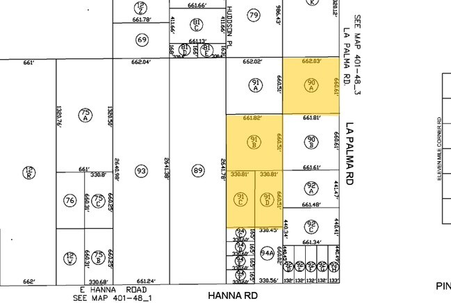
Surveys
401-48-091B
COM @ E1/4 COR OF SEC 08-07S-08E TH W-660.02 TH S-660.51 TO POB T H CONT S-660.51 TH W-661.61 TH N-660.41 TH E-661.82 TO POB AKA LO T 2 BK-8 OF SURVEYS PG-297 10.03 AC
Vacantlandnec
Pinal
X
Arizona
04021C1600E
2
2024
10.03 AC
2025
Pinal County
001900
Phoenix
DEMOGRAPHICS near 6375 N La Palma Rd
1 Mile
3 Mile
5 Mile
2024 Total Population
78
433
6,377
2029 Population
99
541
8,177
Pop Growth 2024-2029
+ 26.92%
+ 24.94%
+ 28.23%
Average Age
40
43
37
2024 Total Households
24
154
2,054
HH Growth 2024-2029
+ 25.00%
+ 22.73%
+ 27.51%
Median Household Inc
$79,167
$61,364
$61,349
Avg Household Size
3.10
2.80
3.00
2024 Avg HH Vehicles
3.00
2.00
2.00
Median Home Value
$266,666
$294,999
$161,029
Median Year Built
1996
1995
1995
Nearby Places
Map Layers
Map Styles
 Street
 Aerial
- Restaurants
- Banks
- Shops
- Fitness
- Groceries
Nearby Properties
Address
Land Use
TOTAL SIZE
Lot Size
Zoning
Address
Land Use
TOTAL SIZE
Lot Size
Zoning
2,107,940 SF
564.87 AC
Address
Land Use
TOTAL SIZE
Lot Size
Zoning
33.69 AC
Address
Land Use
TOTAL SIZE
Lot Size
Zoning
30,877 SF
40 AC
GR
Address
Land Use
TOTAL SIZE
Lot Size
Zoning
116.28 AC
Address
Land Use
TOTAL SIZE
Lot Size
Zoning
2,906 SF
38.05 AC
Address
Land Use
TOTAL SIZE
Lot Size
Zoning
73.05 AC
Address
Land Use
TOTAL SIZE
Lot Size
Zoning
50.97 AC
Address
Land Use
TOTAL SIZE
Lot Size
Zoning
54.59 AC
Address
Land Use
TOTAL SIZE
Lot Size
Zoning
28.93 AC
Address
Land Use
TOTAL SIZE
Lot Size
Zoning
9,464 SF
7.56 AC
GR
Address
Land Use
TOTAL SIZE
Lot Size
Zoning
160 AC
UNDESIGNAT
Address
Land Use
TOTAL SIZE
Lot Size
Zoning
160 AC
UNDESIGNAT
Address
Land Use
TOTAL SIZE
Lot Size
Zoning
Address
Land Use
TOTAL SIZE
Lot Size
Zoning
7,793 SF
297.50 AC
Address
Land Use
TOTAL SIZE
Lot Size
Zoning
120 AC
UNDESIGNAT
Address
Land Use
TOTAL SIZE
Lot Size
Zoning
243.45 AC
UNDESIGNAT
Address
Land Use
TOTAL SIZE
Lot Size
Zoning
4,800 SF
47 AC
UNDESIGNAT
Address
Land Use
TOTAL SIZE
Lot Size
Zoning
80 AC
Address
Land Use
TOTAL SIZE
Lot Size
Zoning
Address
Land Use
TOTAL SIZE
Lot Size
Zoning
45.78 AC
UNDESIGNAT
Address
Land Use
TOTAL SIZE
Lot Size
Zoning
77 AC
SH
Address
Land Use
TOTAL SIZE
Lot Size
Zoning
40 AC
GR
The World's #1 Commercial Real Estate Marketplace
Connect with us
© 2025 CoStar Group
The information above has been obtained from sources believed reliable. While we do not doubt its accuracy we have not verified it and make no guarantee, warranty or representation about it. It is your responsibility to independently confirm its accuracy and completeness. Any projections, opinions, assumptions, or estimates used are for example only and do not represent the current or future performance of the property. The value of this transaction to you depends on tax and other factors which should be evaluated by your tax, financial, and legal advisors. You and your advisors should conduct a careful, independent investigation of the property to determine to your satisfaction the suitability of the property for your needs.