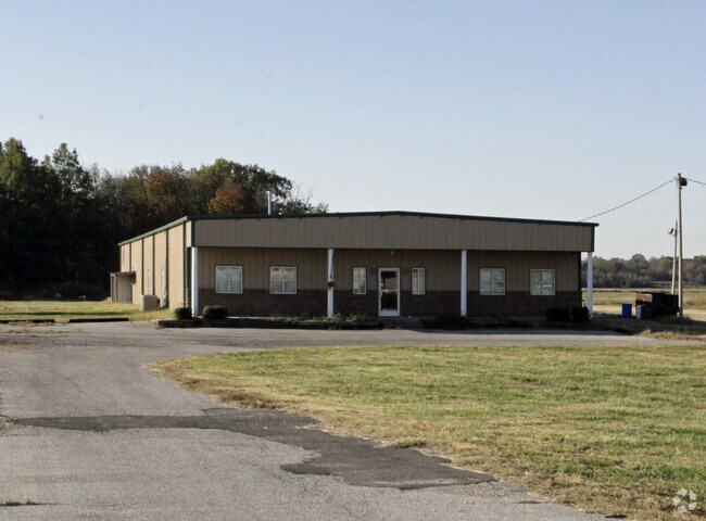
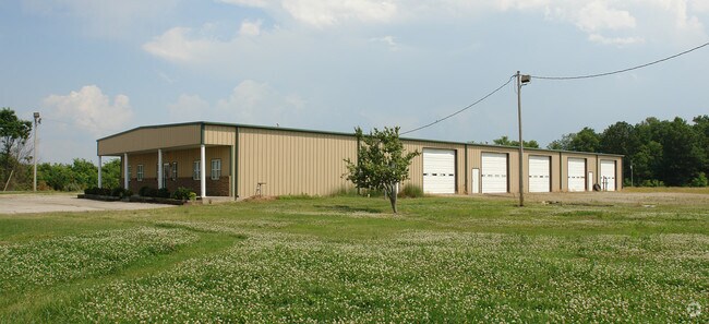
Property Record
6377 Us Highway 70, Marion, AR 72364

Property Detail
6377 Us Highway 70
103-978000-000
W 585.52' OF N 1787.26' N1/2 DRAWING ON FILE EXEMPT FOR 2011 FORWARD, HAS BEEN DONATED TO LAW ENFORCEMENT USE THE PAST SEVERA
Charitableorganization
CRITTENDEN
AE The base floodplain where base flood elevations are provided. AE Zones are now used on new format FIRMs instead of A1-A30 Zones.
Arkansas
0
14.20 AC
2025
Crittenden County
030602
Memphis
10,500 SF
Memphis, TN-MS-AR
NEARBY LISTINGS FOR SALE OR LEASE
-
-
View all Marion listings for sale on LoopNet.com
DEMOGRAPHICS near 6377 Us Highway 70
1 mile
3 mile
5 mile
2025 Total Population
258
12,827
30,903
2030 Population
248
12,318
30,064
Pop Growth 2025-2030
(3.88%)
(3.97%)
(2.71%)
Average Age
43
40
39
2025 Total Households
102
5,247
12,174
HH Growth 2025-2030
(3.92%)
(4.08%)
(2.84%)
Median Household Inc
$70,499
$52,020
$51,787
Avg Household Size
2.50
2.30
2.40
2025 Avg HH Vehicles
2.00
2.00
2.00
Median Home Value
$211,290
$157,541
$152,317
Median Year Built
1990
1977
1981
Nearby Places
Map Layers
Map Styles
 Street
 Aerial
Layers
 Traffic
 Biking
Places
Listings with unknown addresses are not visible on the map
- Restaurants
- Banks
- Shops
- Fitness
- Groceries
PUBLIC TRANSPORTATION
AIRPORT
Memphis International
Drive
Walk
Distance
Memphis International
34 min
20.4 mi
Nearby Properties
Address
Land Use
TOTAL SIZE
Lot Size
Zoning
Address
Land Use
TOTAL SIZE
Lot Size
Zoning
361,843 SF
160 AC
Address
Land Use
TOTAL SIZE
Lot Size
Zoning
847,384 SF
77.14 AC
Address
Land Use
TOTAL SIZE
Lot Size
Zoning
600,000 SF
36.16 AC
Address
Land Use
TOTAL SIZE
Lot Size
Zoning
665,000 SF
46.40 AC
Address
Land Use
TOTAL SIZE
Lot Size
Zoning
209,064 SF
26.97 AC
Address
Land Use
TOTAL SIZE
Lot Size
Zoning
79,208 SF
3.98 AC
Address
Land Use
TOTAL SIZE
Lot Size
Zoning
87,608 SF
10.02 AC
Address
Land Use
TOTAL SIZE
Lot Size
Zoning
28,600 SF
7 AC
Address
Land Use
TOTAL SIZE
Lot Size
Zoning
7,482 SF
7.17 AC
Address
Land Use
TOTAL SIZE
Lot Size
Zoning
194,110 SF
125.33 AC
Address
Land Use
TOTAL SIZE
Lot Size
Zoning
131,846 SF
27.83 AC
Address
Land Use
TOTAL SIZE
Lot Size
Zoning
328,229 SF
20 AC
Address
Land Use
TOTAL SIZE
Lot Size
Zoning
2,728 SF
10.54 AC
Address
Land Use
TOTAL SIZE
Lot Size
Zoning
85,627 SF
36.79 AC
Address
Land Use
TOTAL SIZE
Lot Size
Zoning
7,056 SF
7.63 AC
Address
Land Use
TOTAL SIZE
Lot Size
Zoning
35,796 SF
1.75 AC
Address
Land Use
TOTAL SIZE
Lot Size
Zoning
64,000 SF
54.34 AC
Address
Land Use
TOTAL SIZE
Lot Size
Zoning
28,746 SF
3.11 AC
Address
Land Use
TOTAL SIZE
Lot Size
Zoning
3,108 SF
6.94 AC
Address
Land Use
TOTAL SIZE
Lot Size
Zoning
22,680 SF
3.84 AC
Address
Land Use
TOTAL SIZE
Lot Size
Zoning
16,506 SF
4.30 AC
Address
Land Use
TOTAL SIZE
Lot Size
Zoning
16,664 SF
5.54 AC
Address
Land Use
TOTAL SIZE
Lot Size
Zoning
3,693 SF
7.38 AC
Address
Land Use
TOTAL SIZE
Lot Size
Zoning
2,592 SF
5 AC
Address
Land Use
TOTAL SIZE
Lot Size
Zoning
3,540 SF
7.80 AC
Address
Land Use
TOTAL SIZE
Lot Size
Zoning
46,510 SF
5.56 AC
Address
Land Use
TOTAL SIZE
Lot Size
Zoning
30,756 SF
1.95 AC
Address
Land Use
TOTAL SIZE
Lot Size
Zoning
19,126 SF
30 AC
Address
Land Use
TOTAL SIZE
Lot Size
Zoning
21,720 SF
2.40 AC
Address
Land Use
TOTAL SIZE
Lot Size
Zoning
11,310 SF
4.07 AC
The World's #1 Commercial Real Estate Marketplace
Connect with us
© 2026 CoStar Group
The information above has been obtained from sources believed reliable. While we do not doubt its accuracy we have not verified it and make no guarantee, warranty or representation about it. It is your responsibility to independently confirm its accuracy and completeness. Any projections, opinions, assumptions, or estimates used are for example only and do not represent the current or future performance of the property. The value of this transaction to you depends on tax and other factors which should be evaluated by your tax, financial, and legal advisors. You and your advisors should conduct a careful, independent investigation of the property to determine to your satisfaction the suitability of the property for your needs.