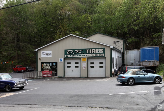
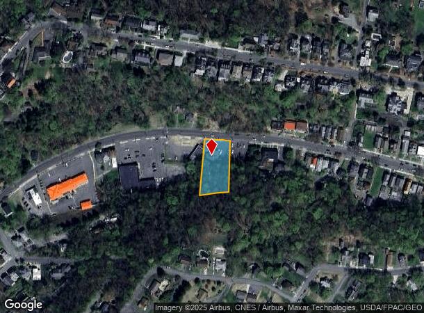
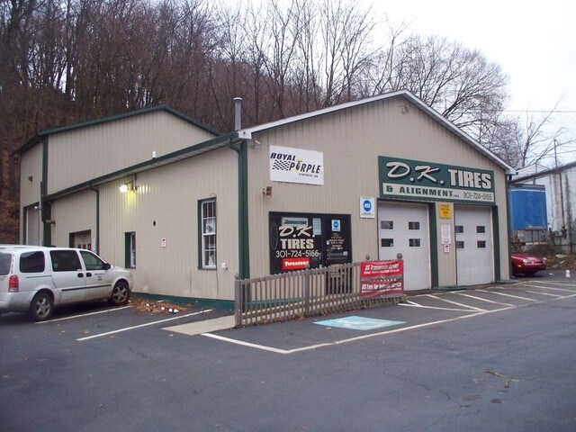
Property Record
638 Greene St, Cumberland, MD 21502
NEARBY LISTINGS FOR SALE OR LEASE
Property Detail
638 Greene St
06-031005
638 GREENE ST 111X240 99X231
Autorepair
Allegany
2025
Maryland
2025
0.57 AC
001200
Other Market Areas
3,291 SF
Cumberland, MD-WV
DEMOGRAPHICS near 638 Greene St
1 Mile
3 Mile
5 Mile
2024 Total Population
6,996
31,635
40,810
2029 Population
6,937
31,323
40,249
Pop Growth 2024-2029
(0.84%)
(0.99%)
(1.37%)
Average Age
43
43
43
2024 Total Households
3,329
13,069
16,102
HH Growth 2024-2029
(1.08%)
(1.19%)
(1.61%)
Median Household Inc
$51,217
$49,059
$49,933
Avg Household Size
2.00
2.20
2.20
2024 Avg HH Vehicles
1.00
2.00
2.00
Median Home Value
$126,082
$136,294
$140,504
Median Year Built
1947
1952
1954
Nearby Places
Map Layers
Map Styles
 Street
 Aerial
- Restaurants
- Banks
- Shops
- Fitness
- Groceries
PUBLIC TRANSPORTATION
COMMUTER RAIL
DRIVE
WALK
Distance
4 min
1.5 mi
Nearby Properties
Address
Land Use
TOTAL SIZE
Lot Size
Zoning
Address
Land Use
TOTAL SIZE
Lot Size
Zoning
11,700 SF
35.95 AC
G
Address
Land Use
TOTAL SIZE
Lot Size
Zoning
40,845 SF
26.24 AC
R-O
Address
Land Use
TOTAL SIZE
Lot Size
Zoning
45,960 SF
308.49 AC
G
Address
Land Use
TOTAL SIZE
Lot Size
Zoning
120,680 SF
0.64 AC
Address
Land Use
TOTAL SIZE
Lot Size
Zoning
708 SF
52.22 AC
Address
Land Use
TOTAL SIZE
Lot Size
Zoning
184,242 SF
18.50 AC
R-L
Address
Land Use
TOTAL SIZE
Lot Size
Zoning
64,000 SF
4.57 AC
Address
Land Use
TOTAL SIZE
Lot Size
Zoning
56,963 SF
3.17 AC
Address
Land Use
TOTAL SIZE
Lot Size
Zoning
46,785 SF
6.60 AC
Address
Land Use
TOTAL SIZE
Lot Size
Zoning
151,773 SF
4.48 AC
Address
Land Use
TOTAL SIZE
Lot Size
Zoning
67,844 SF
11.25 AC
Address
Land Use
TOTAL SIZE
Lot Size
Zoning
11,400 SF
47.37 AC
Address
Land Use
TOTAL SIZE
Lot Size
Zoning
38,489 SF
1.46 AC
B-CBD
Address
Land Use
TOTAL SIZE
Lot Size
Zoning
7,452 SF
5.46 AC
Address
Land Use
TOTAL SIZE
Lot Size
Zoning
4,972 SF
5.37 AC
B
Address
Land Use
TOTAL SIZE
Lot Size
Zoning
48,041 SF
3.62 AC
Address
Land Use
TOTAL SIZE
Lot Size
Zoning
20,000 SF
8.69 AC
Address
Land Use
TOTAL SIZE
Lot Size
Zoning
63,412 SF
5.45 AC
R-PUD
Address
Land Use
TOTAL SIZE
Lot Size
Zoning
65,676 SF
17.50 AC
B-L
Address
Land Use
TOTAL SIZE
Lot Size
Zoning
61,486 SF
5.94 AC
Address
Land Use
TOTAL SIZE
Lot Size
Zoning
55,771 SF
2.42 AC
B
Address
Land Use
TOTAL SIZE
Lot Size
Zoning
50,040 SF
1.52 AC
B-CBD
Address
Land Use
TOTAL SIZE
Lot Size
Zoning
46,845 SF
38.24 AC
R-R
Address
Land Use
TOTAL SIZE
Lot Size
Zoning
56,988 SF
0.34 AC
Address
Land Use
TOTAL SIZE
Lot Size
Zoning
13,014 SF
83.55 AC
R
Address
Land Use
TOTAL SIZE
Lot Size
Zoning
79,296 SF
2.06 AC
R-L
Address
Land Use
TOTAL SIZE
Lot Size
Zoning
59,849 SF
25 AC
R-PUD
Address
Land Use
TOTAL SIZE
Lot Size
Zoning
109,875 SF
39.52 AC
R-S
Address
Land Use
TOTAL SIZE
Lot Size
Zoning
36,794 SF
3.95 AC
I-C
Address
Land Use
TOTAL SIZE
Lot Size
Zoning
720 SF
30 AC
I-G
The World's #1 Commercial Real Estate Marketplace
Connect with us
© 2025 CoStar Group
The information above has been obtained from sources believed reliable. While we do not doubt its accuracy we have not verified it and make no guarantee, warranty or representation about it. It is your responsibility to independently confirm its accuracy and completeness. Any projections, opinions, assumptions, or estimates used are for example only and do not represent the current or future performance of the property. The value of this transaction to you depends on tax and other factors which should be evaluated by your tax, financial, and legal advisors. You and your advisors should conduct a careful, independent investigation of the property to determine to your satisfaction the suitability of the property for your needs.