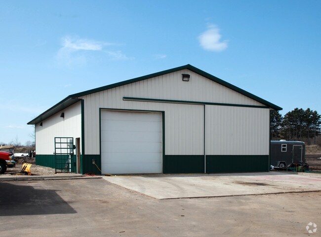
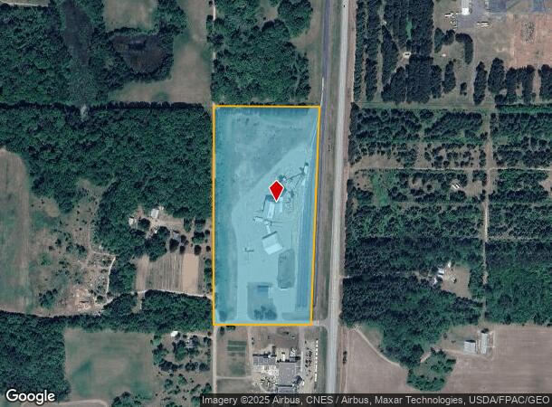
Property Record
6384 415Th St, North Branch, MN 55056

NEARBY LISTINGS FOR SALE OR LEASE
-
-
View all North Branch listings for sale on LoopNet.com
Property Detail
6384 415Th St
11-00055-10
PT OF S1/2 OF NW1/4 LYING W OF C/L OF FOREST BLVD EXCEPT RR R/W.
Commercialnec
Chisago
X
Minnesota
27025C0165D
20 AC
2024
Chisago County
2024
Minneapolis/St Paul
110301
Minneapolis-St. Paul-Bloomington, MN-WI
6,000 SF
DEMOGRAPHICS near 6384 415Th St
1 Mile
3 Mile
5 Mile
2024 Total Population
459
5,973
13,784
2029 Population
484
6,304
14,623
Pop Growth 2024-2029
+ 5.45%
+ 5.54%
+ 6.09%
Average Age
39
39
39
2024 Total Households
158
2,278
5,049
HH Growth 2024-2029
+ 5.06%
+ 5.62%
+ 6.16%
Median Household Inc
$115,624
$88,902
$93,188
Avg Household Size
2.80
2.60
2.70
2024 Avg HH Vehicles
3.00
2.00
2.00
Median Home Value
$278,260
$259,535
$260,113
Median Year Built
1991
1989
1993
Nearby Places
Map Layers
Map Styles
 Street
 Aerial
- Restaurants
- Banks
- Shops
- Fitness
- Groceries
SALE & LEASE HISTORY
LISTING DATE
SALE/LEASE

Feb 23, 2021
For Sale
Nearby Properties
Address
Land Use
TOTAL SIZE
Lot Size
Zoning
Address
Land Use
TOTAL SIZE
Lot Size
Zoning
2,700 SF
52.19 AC
I2
Address
Land Use
TOTAL SIZE
Lot Size
Zoning
150,000 SF
27.15 AC
Address
Land Use
TOTAL SIZE
Lot Size
Zoning
61,103 SF
6.94 AC
Address
Land Use
TOTAL SIZE
Lot Size
Zoning
42,052 SF
3.89 AC
Address
Land Use
TOTAL SIZE
Lot Size
Zoning
53,041 SF
5.43 AC
B2
Address
Land Use
TOTAL SIZE
Lot Size
Zoning
58,368 SF
3.38 AC
R3
Address
Land Use
TOTAL SIZE
Lot Size
Zoning
80,358 SF
8.31 AC
B2
Address
Land Use
TOTAL SIZE
Lot Size
Zoning
58,024 SF
3.30 AC
R3
Address
Land Use
TOTAL SIZE
Lot Size
Zoning
45,756 SF
0.40 AC
CBD
Address
Land Use
TOTAL SIZE
Lot Size
Zoning
42,822 SF
3.04 AC
R3
Address
Land Use
TOTAL SIZE
Lot Size
Zoning
103,679 SF
17.47 AC
I
Address
Land Use
TOTAL SIZE
Lot Size
Zoning
57,840 SF
10.18 AC
I2
Address
Land Use
TOTAL SIZE
Lot Size
Zoning
14,030 SF
16.50 AC
I2
Address
Land Use
TOTAL SIZE
Lot Size
Zoning
49,800 SF
1.12 AC
I3
Address
Land Use
TOTAL SIZE
Lot Size
Zoning
20,520 SF
3.04 AC
B2
Address
Land Use
TOTAL SIZE
Lot Size
Zoning
28,450 SF
15.27 AC
I2
Address
Land Use
TOTAL SIZE
Lot Size
Zoning
18,000 SF
2 AC
B3
Address
Land Use
TOTAL SIZE
Lot Size
Zoning
7,241 SF
2.84 AC
Address
Land Use
TOTAL SIZE
Lot Size
Zoning
21,800 SF
6 AC
I2
Address
Land Use
TOTAL SIZE
Lot Size
Zoning
39,300 SF
10.30 AC
Address
Land Use
TOTAL SIZE
Lot Size
Zoning
4,480 SF
42 AC
I2
Address
Land Use
TOTAL SIZE
Lot Size
Zoning
4,530 SF
1.40 AC
B2
Address
Land Use
TOTAL SIZE
Lot Size
Zoning
22,900 SF
13.70 AC
I
Address
Land Use
TOTAL SIZE
Lot Size
Zoning
16,066 SF
13.70 AC
B3
Address
Land Use
TOTAL SIZE
Lot Size
Zoning
16,224 SF
3.29 AC
I4
Address
Land Use
TOTAL SIZE
Lot Size
Zoning
5,187 SF
2.32 AC
B3
Address
Land Use
TOTAL SIZE
Lot Size
Zoning
34,400 SF
6.30 AC
I
Address
Land Use
TOTAL SIZE
Lot Size
Zoning
19,200 SF
9.60 AC
B3
Address
Land Use
TOTAL SIZE
Lot Size
Zoning
6,024 SF
0.71 AC
B3
The World's #1 Commercial Real Estate Marketplace
Connect with us
© 2025 CoStar Group
The information above has been obtained from sources believed reliable. While we do not doubt its accuracy we have not verified it and make no guarantee, warranty or representation about it. It is your responsibility to independently confirm its accuracy and completeness. Any projections, opinions, assumptions, or estimates used are for example only and do not represent the current or future performance of the property. The value of this transaction to you depends on tax and other factors which should be evaluated by your tax, financial, and legal advisors. You and your advisors should conduct a careful, independent investigation of the property to determine to your satisfaction the suitability of the property for your needs.