Property Record
6325 Old National Hwy, Atlanta, GA 30349
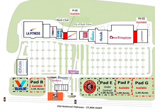
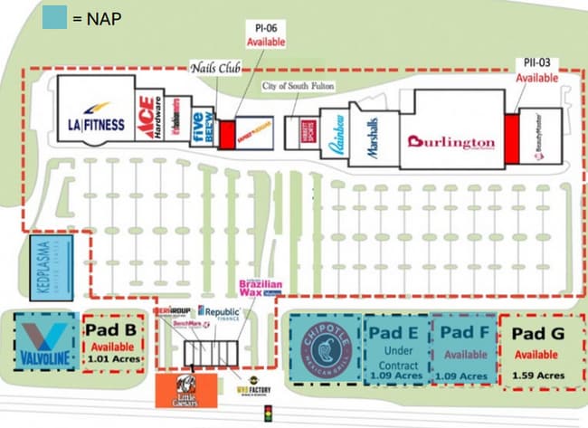
Current Lease Availabilities
NEARBY LISTINGS FOR SALE OR LEASE
Property Detail
6325 Old National Hwy
Atlanta-Sandy Springs-Roswell, GA
Old National Marketplace
13-0132-LL-341-3
Fulton
Commercialacreage
Georgia
X
f
13121C0478F
1.10 AC
2024
North Clayton/Airport
2025
Atlanta
010518
DEMOGRAPHICS near 6325 Old National Hwy
1 Mile
3 Mile
5 Mile
2024 Total Population
9,145
71,623
151,459
2029 Population
9,383
72,927
154,656
Pop Growth 2024-2029
+ 2.60%
+ 1.82%
+ 2.11%
Average Age
39
37
37
2024 Total Households
3,259
26,776
57,545
HH Growth 2024-2029
+ 2.64%
+ 1.69%
+ 2.03%
Median Household Inc
$75,869
$59,339
$57,661
Avg Household Size
2.70
2.60
2.60
2024 Avg HH Vehicles
2.00
2.00
2.00
Median Home Value
$260,121
$242,893
$251,970
Median Year Built
1994
1986
1987
Nearby Places
Map Layers
Map Styles
 Street
 Aerial
- Restaurants
- Banks
- Shops
- Fitness
- Groceries
PUBLIC TRANSPORTATION
AIRPORT
Hartsfield - Jackson Atlanta International
DRIVE
WALK
Distance
Hartsfield - Jackson Atlanta International
17 min
8.8 mi
Freight Ports
Georgia Ports - Savannah
DRIVE
WALK
Distance
Georgia Ports - Savannah
277 min
243.9 mi
Nearby Properties
Address
Land Use
TOTAL SIZE
Lot Size
Zoning
Address
Land Use
TOTAL SIZE
Lot Size
Zoning
2,329,350 SF
32.55 AC
A
Address
Land Use
TOTAL SIZE
Lot Size
Zoning
115.30 AC
I
Address
Land Use
TOTAL SIZE
Lot Size
Zoning
699 SF
44.34 AC
RM
Address
Land Use
TOTAL SIZE
Lot Size
Zoning
240 SF
26.94 AC
RM
Address
Land Use
TOTAL SIZE
Lot Size
Zoning
1,026,040 SF
72.52 AC
M1
Address
Land Use
TOTAL SIZE
Lot Size
Zoning
948,900 SF
16.24 AC
RM
Address
Land Use
TOTAL SIZE
Lot Size
Zoning
4,381,104 SF
26.70 AC
AG1
Address
Land Use
TOTAL SIZE
Lot Size
Zoning
216 SF
24.45 AC
RM
Address
Land Use
TOTAL SIZE
Lot Size
Zoning
352 SF
32.69 AC
RM
Address
Land Use
TOTAL SIZE
Lot Size
Zoning
85,347 SF
49.56 AC
AG1
Address
Land Use
TOTAL SIZE
Lot Size
Zoning
296 SF
27.93 AC
RM
Address
Land Use
TOTAL SIZE
Lot Size
Zoning
264 SF
24.92 AC
RM
Address
Land Use
TOTAL SIZE
Lot Size
Zoning
855,399 SF
41.79 AC
C2
Address
Land Use
TOTAL SIZE
Lot Size
Zoning
3,904,656 SF
30.58 AC
RM
Address
Land Use
TOTAL SIZE
Lot Size
Zoning
370 SF
36.20 AC
RM
Address
Land Use
TOTAL SIZE
Lot Size
Zoning
3,259,200 SF
17.69 AC
MF
Address
Land Use
TOTAL SIZE
Lot Size
Zoning
4,461,259 SF
18.79 AC
MF
Address
Land Use
TOTAL SIZE
Lot Size
Zoning
248 SF
24.63 AC
RM
Address
Land Use
TOTAL SIZE
Lot Size
Zoning
358,011 SF
60.44 AC
AG1
Address
Land Use
TOTAL SIZE
Lot Size
Zoning
177 SF
23.79 AC
RM
Address
Land Use
TOTAL SIZE
Lot Size
Zoning
9.05 AC
C
Address
Land Use
TOTAL SIZE
Lot Size
Zoning
234,763 SF
22.43 AC
OI
Address
Land Use
TOTAL SIZE
Lot Size
Zoning
281,032 SF
18.03 AC
M1
Address
Land Use
TOTAL SIZE
Lot Size
Zoning
147,540 SF
47.10 AC
C RP
Address
Land Use
TOTAL SIZE
Lot Size
Zoning
1,545,096 SF
10.05 AC
MF
Address
Land Use
TOTAL SIZE
Lot Size
Zoning
312,240 SF
38.93 AC
MIA
Address
Land Use
TOTAL SIZE
Lot Size
Zoning
178,002 SF
39.88 AC
OI
Address
Land Use
TOTAL SIZE
Lot Size
Zoning
230,068 SF
22.64 AC
M1
Address
Land Use
TOTAL SIZE
Lot Size
Zoning
369,000 SF
43.81 AC
AC
Address
Land Use
TOTAL SIZE
Lot Size
Zoning
212 SF
20.18 AC
RM
The World's #1 Commercial Real Estate Marketplace
Connect with us
© 2025 CoStar Group
The information above has been obtained from sources believed reliable. While we do not doubt its accuracy we have not verified it and make no guarantee, warranty or representation about it. It is your responsibility to independently confirm its accuracy and completeness. Any projections, opinions, assumptions, or estimates used are for example only and do not represent the current or future performance of the property. The value of this transaction to you depends on tax and other factors which should be evaluated by your tax, financial, and legal advisors. You and your advisors should conduct a careful, independent investigation of the property to determine to your satisfaction the suitability of the property for your needs.