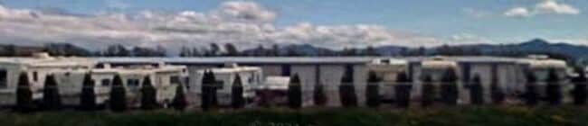
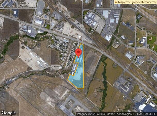
Property Record
6385 Us Highway 10 W, Missoula, MT 59808
NEARBY LISTINGS FOR SALE OR LEASE
Property Detail
6385 Us Highway 10 W
04-2325-34-1-02-01-0000
S34, T14 N, R20 W, ACRES 16.94, IN E1/2 E1/2
Commercialnec
Missoula
X
Montana
30063C1190E
16.94 AC
2024
Missoula
2025
Other Market Areas
001602
Missoula, MT
18,450 SF
DEMOGRAPHICS near 6385 Us Highway 10 W
1 Mile
3 Mile
5 Mile
2024 Total Population
428
8,833
24,298
2029 Population
467
9,588
26,436
Pop Growth 2024-2029
+ 9.11%
+ 8.55%
+ 8.80%
Average Age
38
38
40
2024 Total Households
165
3,405
10,374
HH Growth 2024-2029
+ 9.09%
+ 8.72%
+ 9.13%
Median Household Inc
$102,344
$91,971
$76,566
Avg Household Size
2.50
2.50
2.20
2024 Avg HH Vehicles
2.00
2.00
2.00
Median Home Value
$480,434
$348,991
$375,092
Median Year Built
2004
2003
2003
Nearby Places
Map Layers
Map Styles
 Street
 Aerial
- Restaurants
- Banks
- Shops
- Fitness
- Groceries
PUBLIC TRANSPORTATION
AIRPORT
Missoula Montana
DRIVE
WALK
Distance
Missoula Montana
5 min
1.9 mi
Freight Ports
Port of Everett
DRIVE
WALK
Distance
Port of Everett
542 min
491.8 mi
Nearby Properties
Address
Land Use
TOTAL SIZE
Lot Size
Zoning
Address
Land Use
TOTAL SIZE
Lot Size
Zoning
61,762 SF
8.48 AC
Address
Land Use
TOTAL SIZE
Lot Size
Zoning
61,800 SF
6.11 AC
Address
Land Use
TOTAL SIZE
Lot Size
Zoning
73,710 SF
12.42 AC
Address
Land Use
TOTAL SIZE
Lot Size
Zoning
73,710 SF
12.42 AC
Address
Land Use
TOTAL SIZE
Lot Size
Zoning
55,280 SF
3.12 AC
Address
Land Use
TOTAL SIZE
Lot Size
Zoning
98,144 SF
7.50 AC
6
Address
Land Use
TOTAL SIZE
Lot Size
Zoning
1,342.09 AC
Address
Land Use
TOTAL SIZE
Lot Size
Zoning
34,404 SF
10.25 AC
6
Address
Land Use
TOTAL SIZE
Lot Size
Zoning
14,910 SF
4.15 AC
Address
Land Use
TOTAL SIZE
Lot Size
Zoning
81,829 SF
3.53 AC
1
Address
Land Use
TOTAL SIZE
Lot Size
Zoning
46,236 SF
3.03 AC
1
Address
Land Use
TOTAL SIZE
Lot Size
Zoning
63,776 SF
10.68 AC
Address
Land Use
TOTAL SIZE
Lot Size
Zoning
68,310 SF
5.41 AC
Address
Land Use
TOTAL SIZE
Lot Size
Zoning
72,000 SF
7.67 AC
Address
Land Use
TOTAL SIZE
Lot Size
Zoning
128,173 SF
5.89 AC
Address
Land Use
TOTAL SIZE
Lot Size
Zoning
34,090 SF
2.76 AC
6
Address
Land Use
TOTAL SIZE
Lot Size
Zoning
116,188 SF
3.05 AC
Address
Land Use
TOTAL SIZE
Lot Size
Zoning
21,622 SF
14.69 AC
Address
Land Use
TOTAL SIZE
Lot Size
Zoning
55,800 SF
1.33 AC
Address
Land Use
TOTAL SIZE
Lot Size
Zoning
135,960 SF
9.31 AC
Address
Land Use
TOTAL SIZE
Lot Size
Zoning
54,732 SF
8.25 AC
1
Address
Land Use
TOTAL SIZE
Lot Size
Zoning
30,217 SF
18.51 AC
Address
Land Use
TOTAL SIZE
Lot Size
Zoning
23,076 SF
1.15 AC
Address
Land Use
TOTAL SIZE
Lot Size
Zoning
80,050 SF
8.34 AC
Address
Land Use
TOTAL SIZE
Lot Size
Zoning
57,518 SF
4.72 AC
1
Address
Land Use
TOTAL SIZE
Lot Size
Zoning
43,306 SF
Address
Land Use
TOTAL SIZE
Lot Size
Zoning
94,101 SF
7.02 AC
Address
Land Use
TOTAL SIZE
Lot Size
Zoning
70,561 SF
4.63 AC
The World's #1 Commercial Real Estate Marketplace
Connect with us
© 2025 CoStar Group
The information above has been obtained from sources believed reliable. While we do not doubt its accuracy we have not verified it and make no guarantee, warranty or representation about it. It is your responsibility to independently confirm its accuracy and completeness. Any projections, opinions, assumptions, or estimates used are for example only and do not represent the current or future performance of the property. The value of this transaction to you depends on tax and other factors which should be evaluated by your tax, financial, and legal advisors. You and your advisors should conduct a careful, independent investigation of the property to determine to your satisfaction the suitability of the property for your needs.