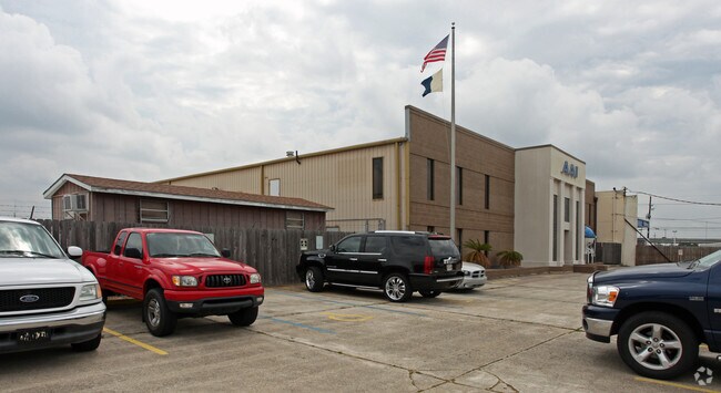
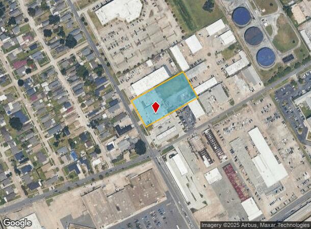
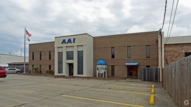
Property Record
639 Manhattan Blvd, Harvey, LA 70058
NEARBY LISTINGS FOR SALE OR LEASE
Property Detail
639 Manhattan Blvd
New Orleans-Metairie, LA
Leson Court Sub
0300006806
LOT D LESON CT
Realpropertynec
Jefferson
X
Louisiana
22051C0215F
d
2024
1.80 AC
2024
Westbank
026000
New Orleans/Metairie/Kenner
DEMOGRAPHICS near 639 Manhattan Blvd
1 Mile
3 Mile
5 Mile
2024 Total Population
13,438
128,647
344,414
2029 Population
13,028
124,462
332,453
Pop Growth 2024-2029
(3.05%)
(3.25%)
(3.47%)
Average Age
39
41
40
2024 Total Households
5,305
57,028
147,005
HH Growth 2024-2029
(3.19%)
(3.25%)
(3.42%)
Median Household Inc
$36,637
$51,611
$52,985
Avg Household Size
2.30
2.20
2.20
2024 Avg HH Vehicles
1.00
1.00
1.00
Median Home Value
$183,980
$252,472
$246,791
Median Year Built
1966
1964
1962
Nearby Places
Map Layers
Map Styles
 Street
 Aerial
- Restaurants
- Banks
- Shops
- Fitness
- Groceries
PUBLIC TRANSPORTATION
COMMUTER RAIL
DRIVE
WALK
Distance
10 min
6.1 mi
AIRPORT
Louis Armstrong New Orleans International
DRIVE
WALK
Distance
Louis Armstrong New Orleans International
29 min
20.4 mi
Freight Ports
Plaquemines Port
DRIVE
WALK
Distance
Plaquemines Port
12 min
6.5 mi
Nearby Properties
Address
Land Use
TOTAL SIZE
Lot Size
Zoning
Address
Land Use
TOTAL SIZE
Lot Size
Zoning
44.43 AC
CBD-4
Address
Land Use
TOTAL SIZE
Lot Size
Zoning
3.66 AC
MC
Address
Land Use
TOTAL SIZE
Lot Size
Zoning
18.31 AC
CBD-4
Address
Land Use
TOTAL SIZE
Lot Size
Zoning
844,362 SF
5.85 AC
CBD-4
Address
Land Use
TOTAL SIZE
Lot Size
Zoning
0.12 AC
Address
Land Use
TOTAL SIZE
Lot Size
Zoning
Address
Land Use
TOTAL SIZE
Lot Size
Zoning
444,121 SF
1.46 AC
CBD-1
Address
Land Use
TOTAL SIZE
Lot Size
Zoning
1.91 AC
CBD-1
Address
Land Use
TOTAL SIZE
Lot Size
Zoning
512,729 SF
6.60 AC
Address
Land Use
TOTAL SIZE
Lot Size
Zoning
0.67 AC
CBD-3
Address
Land Use
TOTAL SIZE
Lot Size
Zoning
0.14 AC
Address
Land Use
TOTAL SIZE
Lot Size
Zoning
202,291 SF
4.04 AC
HU-RD2
Address
Land Use
TOTAL SIZE
Lot Size
Zoning
2.94 AC
CBD-1
Address
Land Use
TOTAL SIZE
Lot Size
Zoning
4.12 AC
Address
Land Use
TOTAL SIZE
Lot Size
Zoning
462,672 SF
1.11 AC
CBD-1
Address
Land Use
TOTAL SIZE
Lot Size
Zoning
246,930 SF
9.40 AC
CBD-4
Address
Land Use
TOTAL SIZE
Lot Size
Zoning
25.26 AC
Address
Land Use
TOTAL SIZE
Lot Size
Zoning
363,470 SF
1.01 AC
CBD-2
Address
Land Use
TOTAL SIZE
Lot Size
Zoning
714,776 SF
1.28 AC
CBD-1
Address
Land Use
TOTAL SIZE
Lot Size
Zoning
1.50 AC
CBD-1
Address
Land Use
TOTAL SIZE
Lot Size
Zoning
559,437 SF
2.03 AC
CBD-4
Address
Land Use
TOTAL SIZE
Lot Size
Zoning
121,349 SF
0.85 AC
CBD-3
Address
Land Use
TOTAL SIZE
Lot Size
Zoning
151,320 SF
27.55 AC
Address
Land Use
TOTAL SIZE
Lot Size
Zoning
0.30 AC
CBD-5
Address
Land Use
TOTAL SIZE
Lot Size
Zoning
361,968 SF
0.50 AC
CBD-1
Address
Land Use
TOTAL SIZE
Lot Size
Zoning
222,425 SF
1.11 AC
CBD-6
Address
Land Use
TOTAL SIZE
Lot Size
Zoning
0.63 AC
CBD-1
Address
Land Use
TOTAL SIZE
Lot Size
Zoning
716,274 SF
0.91 AC
CBD-1
Address
Land Use
TOTAL SIZE
Lot Size
Zoning
21.99 AC
CBD-4
Address
Land Use
TOTAL SIZE
Lot Size
Zoning
1.22 AC
CBD-5
The World's #1 Commercial Real Estate Marketplace
Connect with us
© 2025 CoStar Group
The information above has been obtained from sources believed reliable. While we do not doubt its accuracy we have not verified it and make no guarantee, warranty or representation about it. It is your responsibility to independently confirm its accuracy and completeness. Any projections, opinions, assumptions, or estimates used are for example only and do not represent the current or future performance of the property. The value of this transaction to you depends on tax and other factors which should be evaluated by your tax, financial, and legal advisors. You and your advisors should conduct a careful, independent investigation of the property to determine to your satisfaction the suitability of the property for your needs.