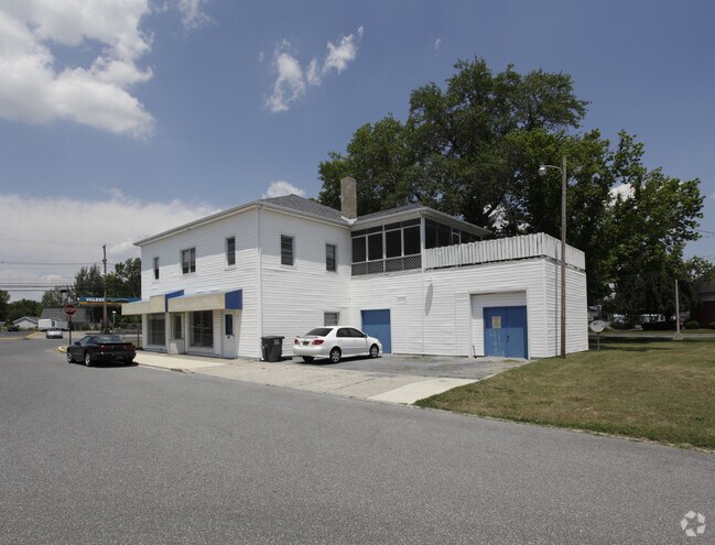
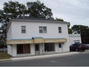
Property Record
639 N Phillips St, Seaford, DE 19973
NEARBY LISTINGS FOR SALE OR LEASE
Property Detail
639 N Phillips St
Salisbury, MD-DE
Seaford
531-13.05-179.00
PHILLIPS ST LOT W/IMP
Commercialnec
Sussex
X
Delaware
10005C0244K
0.50 AC
2025
Sussex County
2025
Philadelphia
050405
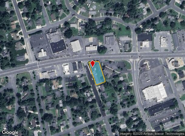
DEMOGRAPHICS near 639 N Phillips St
1 Mile
3 Mile
5 Mile
2024 Total Population
5,599
15,231
25,308
2029 Population
6,500
17,686
29,253
Pop Growth 2024-2029
+ 16.09%
+ 16.12%
+ 15.59%
Average Age
38
40
41
2024 Total Households
1,991
5,550
9,272
HH Growth 2024-2029
+ 15.72%
+ 15.77%
+ 15.22%
Median Household Inc
$58,659
$58,697
$57,678
Avg Household Size
2.70
2.60
2.60
2024 Avg HH Vehicles
2.00
2.00
2.00
Median Home Value
$199,514
$224,036
$226,589
Median Year Built
1977
1986
1989
Nearby Places
Map Layers
Map Styles
 Street
 Aerial
- Restaurants
- Banks
- Shops
- Fitness
- Groceries
PUBLIC TRANSPORTATION
AIRPORT
Salisbury-Ocean City Wicomico Regional
DRIVE
WALK
Distance
Salisbury-Ocean City Wicomico Regional
43 min
28.0 mi
Freight Ports
Port of Baltimore
DRIVE
WALK
Distance
Port of Baltimore
129 min
87.0 mi
Nearby Properties
Address
Land Use
TOTAL SIZE
Lot Size
Zoning
Address
Land Use
TOTAL SIZE
Lot Size
Zoning
523.79 AC
HI-1
Address
Land Use
TOTAL SIZE
Lot Size
Zoning
45.20 AC
TN
Address
Land Use
TOTAL SIZE
Lot Size
Zoning
36.36 AC
TN
Address
Land Use
TOTAL SIZE
Lot Size
Zoning
21.44 AC
TN
Address
Land Use
TOTAL SIZE
Lot Size
Zoning
15.33 AC
TN
Address
Land Use
TOTAL SIZE
Lot Size
Zoning
26.21 AC
TN
Address
Land Use
TOTAL SIZE
Lot Size
Zoning
1.15 AC
TN
Address
Land Use
TOTAL SIZE
Lot Size
Zoning
31.75 AC
TN
Address
Land Use
TOTAL SIZE
Lot Size
Zoning
22.36 AC
TN
Address
Land Use
TOTAL SIZE
Lot Size
Zoning
55.47 AC
TN
Address
Land Use
TOTAL SIZE
Lot Size
Zoning
79.67 AC
MR
Address
Land Use
TOTAL SIZE
Lot Size
Zoning
18.62 AC
TN
Address
Land Use
TOTAL SIZE
Lot Size
Zoning
11.53 AC
TN
Address
Land Use
TOTAL SIZE
Lot Size
Zoning
13.27 AC
TN
Address
Land Use
TOTAL SIZE
Lot Size
Zoning
3.07 AC
TN
Address
Land Use
TOTAL SIZE
Lot Size
Zoning
19.52 AC
TN
Address
Land Use
TOTAL SIZE
Lot Size
Zoning
6.45 AC
TN
Address
Land Use
TOTAL SIZE
Lot Size
Zoning
13.39 AC
TN
Address
Land Use
TOTAL SIZE
Lot Size
Zoning
1.40 AC
TN
Address
Land Use
TOTAL SIZE
Lot Size
Zoning
7.77 AC
TN
Address
Land Use
TOTAL SIZE
Lot Size
Zoning
9.92 AC
TN
Address
Land Use
TOTAL SIZE
Lot Size
Zoning
4.41 AC
TN
Address
Land Use
TOTAL SIZE
Lot Size
Zoning
4,000 SF
4.16 AC
Address
Land Use
TOTAL SIZE
Lot Size
Zoning
18.43 AC
TN
Address
Land Use
TOTAL SIZE
Lot Size
Zoning
3.70 AC
TN
Address
Land Use
TOTAL SIZE
Lot Size
Zoning
1,512 SF
108.37 AC
AR-1
Address
Land Use
TOTAL SIZE
Lot Size
Zoning
5.38 AC
TN
Address
Land Use
TOTAL SIZE
Lot Size
Zoning
4,449 SF
104.48 AC
AR1
Address
Land Use
TOTAL SIZE
Lot Size
Zoning
2.33 AC
TN
The World's #1 Commercial Real Estate Marketplace
Connect with us
© 2025 CoStar Group
The information above has been obtained from sources believed reliable. While we do not doubt its accuracy we have not verified it and make no guarantee, warranty or representation about it. It is your responsibility to independently confirm its accuracy and completeness. Any projections, opinions, assumptions, or estimates used are for example only and do not represent the current or future performance of the property. The value of this transaction to you depends on tax and other factors which should be evaluated by your tax, financial, and legal advisors. You and your advisors should conduct a careful, independent investigation of the property to determine to your satisfaction the suitability of the property for your needs.